Nearby
Mt Alford
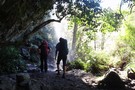
Pudding Hill Stream Route
Track
•
1 day. Medium. One way.
•
Distance: 3.9km away
Unmarked route along Pudding Hill Stream in Mount Hutt Forest. Combine this route with the Scotts Saddle Track for an ...
More ▶︎
Alder Track / Ridge Track / Scotts Saddle Track circuit
Track
•
Easy/medium. Loop track.
•
Distance: 4.1km away
A loop track in forest at the foot of Mount Hutt. Several variations are available.
More ▶︎
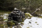
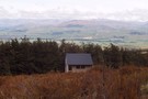
Stone fireplace
Photograph
•
Distance: 5.1km away
Tucked away at the back of some river flats on Pudding Hill Stream.
More ▶︎
Scotts Saddle Track
Track
•
Easy/medium. Return by the same track.
•
Distance: 5.5km away
A short climb from the Awa Awa Rata Reserve to Scotts Saddle on the Mt Hutt Skifield road.
More ▶︎
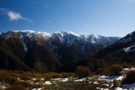
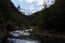
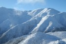
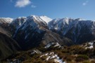
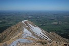
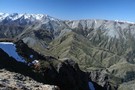
Pudding Hill Range
Photograph
•
Distance: 6.4km away
Looking up to point 1603, from Scott's Track. August 2014.
More ▶︎
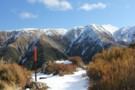
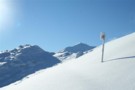
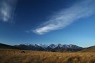
Scott's Saddle
Photograph
•
Distance: 6.5km away
Top of the Scott's Saddle Track on Mount Hutt, looking toward the Pudding Hill Range.
More ▶︎
Woolshed hut
Photograph
•
Distance: 6.6km away
One of two huts on the mount somers walkway and is more like a hotel than a hut.
More ▶︎
Mount Somers Track
Track
•
2 days. Easy/medium. One way.
•
Distance: 6.6km away
Leading around the back of Mount Somers, an ancient volcano, this track explores a fascinating landscape with handsome grasslands and ...
More ▶︎
Mount Somers Summit Track
Track
•
1 day. Easy/medium. Return by the same track.
•
Distance: 6.8km away
The quicker, steeper route to the summit, from Sharplin Falls.
More ▶︎
Staveley Hill
Track
•
Easy. Return via same track.
•
Distance: 7.0km away
Part of the Mt Somers circuit, Staveley Hill climbs from Sharplin Falls carpark and past Hookey Knob along the south ...
More ▶︎
Mt Somers Track (South Face)
Track
•
1 day. Easy/medium. Return by the same track.
•
Distance: 7.1km away
Woolshed Creek Hut - Rhyolite Ridge Track junction (4 km) Time: 2 hr. The route takes in dynamic scenery with ...
More ▶︎
Mt Somers waterfall
Photograph
•
Distance: 7.3km away
A bit over half way into Pinnacles Hut,the track goes behind this pretty little falls;shady & cool on a summers ...
More ▶︎
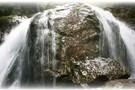
Sharplin falls
Photograph
•
Distance: 7.3km away
At the end of the walk to sharplin falls you'll find this.
More ▶︎
Sharplin falls
Track
•
Easy/medium.
•
Distance: 7.3km away
Walk along a stream to the Sharplin Falls.
Different walks are possible.
More ▶︎
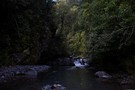
Pudding Hill Stream Route
Photograph
•
Distance: 7.6km away
Setting off from Scott's Saddle, poles lead down 400 metres to the stream below. Point 1751 is across the valley.
More ▶︎
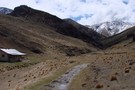
Pinnacles Hut (Hakatere)
Hut
•
Serviced Hut (DOC). Capacity: 19.
•
Distance: 7.9km away
A well-situated hut on the Mount Somers Track. The columnar basalt cliffs of Mount Somers provide a handsome backdrop. Limited ...
More ▶︎
Pinnacles hut
Photograph
•
Distance: 7.9km away
Pinnacles hut, Mt Somers. taken October 2006
More ▶︎
Mount Somers summit
Photograph
•
Distance: 8.7km away
This the main rout to the summit: the ridge leading down to Staveley Hill.
More ▶︎
Mount Somers summit (from Woolshed Creek)
Track
•
2 days. Easy/medium. Return by the same track.
•
Distance: 8.9km away
A gentle climb over untracked tussock land to this easy summit.
More ▶︎
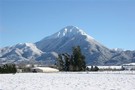
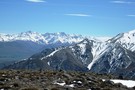
Mt Somers
Photograph
•
Distance: 8.9km away
This high foothill,1688m,gives great panoramas of the Canterbury Plains and views of Mts Cook,Winterslow,Hutt,Taylor,D`Archiac,Peel,Tripp,and more.About seven hours return.This view taken ...
More ▶︎
Hakatere Conservation Park
Place
•
Conservation Park. 600.00km2.
•
Distance: 8.9km away
This park protects high country between the Rakaia and Rangitata Rivers in the Ashburton Lakes District, Mid-Canterbury.
More ▶︎
Te Kiekie route - Mt Somers
Track
•
Medium/hard. Loop track.
•
Distance: 8.9km away
New marked route linking the summit of Mt Somers with the Mt Somers track.
More ▶︎
Arrowsmith Range
Photograph
•
Distance: 9.0km away
Arrowsmith range taken from Mt Somers. Lake Heron also visible. taken October 2006.
More ▶︎
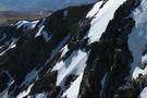
Geological contrasts
Photograph
•
Distance: 9.3km away
The ragged rhyolite cliffs of Mount Somers in the foreground, and the smoother Torlesse greywacke of the Winterslow Range beyond. ...
More ▶︎
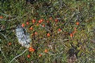
Coprosma perpusilla
Photograph
•
Distance: 9.6km away
Bog at the head of Trifalls Stream, Mount Somers summit.
More ▶︎