Nearby
Hāwea Conservation Park
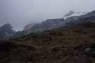
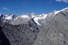
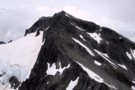
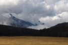
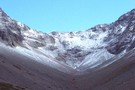
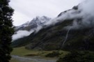
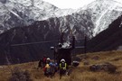
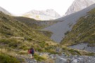
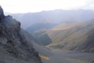
Mt Strauchon from Brodrick
Photograph
•
Distance: less than 100m away
Mt Strauchon vanishes into cloud from the Brodrick Pass
More ▶︎
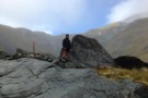
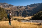
Brewster track to Mt.Armstrong
Track
•
1 – 2 days. Hard. Return via same track.
•
Distance: less than 100m away
An ascent from the state hwy(SH6),just west of Haast Pass,of over 1700m to a summit on the main divide of ...
More ▶︎
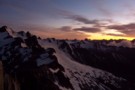
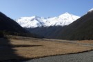
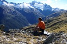
Sunrise from Mt Armstrong
Photograph
•
Distance: 1.1km away
lookin over at the backside of brewster. Well worth the alpine start
More ▶︎
Mad Pom's latest Adventure - Part 5
Article
•
Distance: 1.6km away
A trip to the head of the Landsborough - and all that ensues.
Part 5 - Heroes and Angels.
More ▶︎
Mad Pom's latest Adventure - part 4
Article
•
Distance: 1.6km away
A trip to the head of the Landsborough - and all that ensues.
Part 4: the longest walk.
More ▶︎
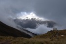
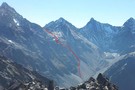
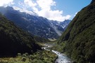
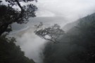
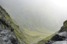
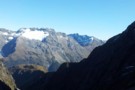
MacKenzie Creek from Brodrick Pass
Photograph
•
Distance: 1.7km away
MacKenzie creek descends towards the Landsborough from Brodrick pass. This hanging valley drops vertically from the limit of this photo ...
More ▶︎
Mad Pom's latest adventure. Part 2
Article
•
Distance: 1.7km away
A trip to the head on the landsborough, and all that ensues. Part two.
More ▶︎
Brodrick Pass
Photograph
•
Distance: 1.7km away
Brodrick Pass from Brodrick Hut, an easy low route into the mid-reaches of the Landsbrorough from the Nth Hxley
More ▶︎
Mad Pom's latest adventure
Article
•
Distance: 1.7km away
A trip to the heads of the Landsborough ... and all that ensues.
More ▶︎
Sth Huxley to Hunter (Forbes) - Pass IS possible!
Photograph
•
Distance: 1.9km away
A steep and somewhat nerve-wracking ascent from the Sth Huxley to the pass into the Hunter at Forbes Hut. I ...
More ▶︎
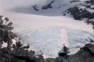
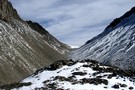
Blue ice on the snout of the Brewster Glacier
Photograph
•
Distance: 2.5km away
The ice visible at the face of the Brewster Glacier is an incredible shade of blue.
More ▶︎
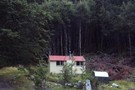
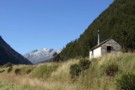
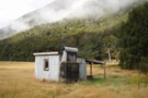
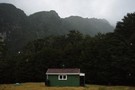
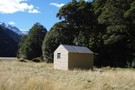
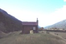
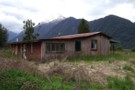
Brodrick Hut
Hut
•
Standard Hut (DOC). Capacity: 6.
•
Distance: 2.6km away
Brodrick Hut (sleeps 6, tank water, stove, firewood available) is a 1960's forestry hut at the base of the Brodrick ...
More ▶︎
Mt Armstrong from Peak 2023
Photograph
•
Distance: 2.8km away
After visiting the Brewster Glacier it is straight forward to climb the stream that flows from beneath Peak 1951 and ...
More ▶︎
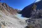
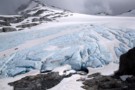
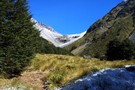
Brewster Glacier
Photograph
•
Distance: 2.9km away
Located only a 90 minute scramble away from Brewster hut, Brewster Glacier is well worth the visit especially if Mt ...
More ▶︎
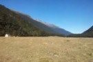
Huxley Valley
Track
•
2 days. Easy/medium. Return via same track.
•
Distance: 3.0km away
Easy walking at the head of Lake Ohau.
More ▶︎
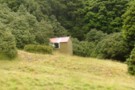
Hagens Hut
Hut
•
Standard Hut (DOC). Capacity: 4.
•
Distance: 3.0km away
Small iron hut on the Ahuriri River flats.
More ▶︎
Wills Hut
Photograph
•
Distance: 3.1km away
A pleasent forestry style hut on flats in the Wills Valley off SH6 Haast Pass. The hut can be reached ...
More ▶︎
Wills Hut
Hut
•
Standard Hut (DOC). Capacity: 4.
•
Distance: 3.1km away
Wills Hut (4 bunk, Stove, river water) is a standard four bunk forestry style hut on tussock flats in the ...
More ▶︎
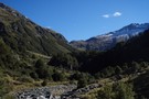
Huxley North Branch
Photograph
•
Distance: 3.1km away
The North Branch of the Huxley towards Brodrick Hut and Mt Strauchon
More ▶︎
Wills hut & valley headwaters March 2009
Photograph
•
Distance: 3.3km away
This pic is from a similar vantage point as "madpoms" but was taken on a cloudless day.
We found the hut ...
More ▶︎
Brewster Hut
Photograph
•
Distance: 3.9km away
On the side of Mt Armstrong looking down at Brewster Hut and Haast Pass further still
More ▶︎
Returning to Haast Pass
Photograph
•
Distance: 3.9km away
Leaving Brewster hut for Haast pass 900M below
More ▶︎
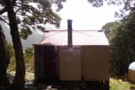
Brewster hut Jan 2009
Photograph
•
Distance: 3.9km away
An alpine hut in the Haast Pass area between Mt Armstrong and the highway. This hut is only a few ...
More ▶︎
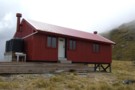
Brewster Hut
Hut
•
Serviced Alpine Hut (DOC). Capacity: 12.Bookings required.
•
Distance: 3.9km away
An alpine hut in the Haast Pass area between Mt Armstrong and the highway. This hut is only a few ...
More ▶︎
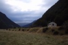
Fraser Hut (Landsborough)
Hut
•
Basic Hut/Bivvy (DOC). Capacity: 4.
•
Distance: 4.2km away
Fraser Hut in the Landsborough is a basic 4-bunk hut on river terraces at the base of the Broderick Pass. ...
More ▶︎
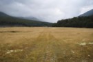
Fraser / Cheswicke Airstrip
Photograph
•
Distance: 4.2km away
Fraser / Cheswicke Airstrip, Landsborough
More ▶︎
The Landsborough at Cheswicke Flat, Fraser Hut
Photograph
•
Distance: 4.2km away
The Landsborough at Cheswicke Flat, Fraser Hut
More ▶︎
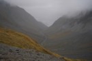
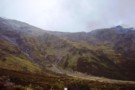
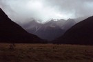
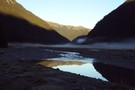
The Landsborough from Brodrick Pass
Photograph
•
Distance: 4.2km away
The Landsborough in cloud. From the ridgeline descent from Brodrick pass via MacKenzie Creek
More ▶︎
Creswicke Flat Hut
Hut
•
Basic Hut/Bivvy (DOC). Capacity: 4.
•
Distance: 4.3km away
Iron hut next to an airstrip on flats of the Landsborough River.
More ▶︎
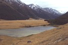
Ahuriri
Photograph
•
Distance: 5.1km away
The Ahuriri Valley and the small tarn opposite Shamrock Hut.
More ▶︎
Bull Flat Hut
Hut
•
Basic Hut/Bivvy (DOC). Capacity: 2.
•
Distance: 5.1km away
Small hut on the Hunter River.
More ▶︎
Forbes Hut (Hunter)
Photograph
•
Distance: 5.3km away
A standard forestry hut in the upper Hunter Valley. At the base of a tricky pass from the Sth Huxley, ...
More ▶︎
Forbes Hut (Hunter)
Hut
•
Standard Hut (DOC). Capacity: 4.
•
Distance: 5.3km away
Forbes Hut is a typical 4 (6?) bunk forestry hut in the Hunter. The hut sits on the last of ...
More ▶︎
Shamrock Hut (Ahuriri)
Hut
•
Basic Hut/Bivvy (DOC). Capacity: 2.
•
Distance: 5.5km away
Shamrock Hut (2 bunks, matreses, fireplace, firewood avail., stream water) is an old station hut in the mid-reaches of the ...
More ▶︎
Shamrock Hut (Ahuriri)
Photograph
•
Distance: 5.5km away
Shamrock Hut in the Ahuriri - an old but comfortable 2-bunk station hut overlooking river flats and a small lake.
More ▶︎
Picton to Aspiring
GPX file
•
Distance: 5.6km away
An aborted alpine traverse. Picton to West Cape, but aborted at Aspiring due to real world emergencies back home. Posted ...
More ▶︎
South Huxley Bivvy
Hut
•
Basic Hut/Bivvy (DOC). Capacity: 2.
•
Distance: 5.7km away
Small hut on the Huxley River South Branch.
More ▶︎
Top Hut (Ahuriri)
Hut
•
Basic Hut/Bivvy (DOC). Capacity: 3.
•
Distance: 5.9km away
This hut now (Jan 2009) boasts 2 wooden bunks with matresses in place of the sack bunks described in 2005. ...
More ▶︎
The Ahuriri from Top Hut
Photograph
•
Distance: 5.9km away
The Ahuriri from Top Hut (after a lot of rain!)
More ▶︎
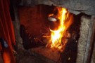
Top Hut - how to burn your boots
Photograph
•
Distance: 5.9km away
How to burn boots - a good fire in the Ahuriri Top Hut
More ▶︎
Top Hut (Ahuriri)
Photograph
•
Distance: 5.9km away
A 2 bunk hut at the top of the Ahuriri flats.
More ▶︎
Top Hut - it's cold out there boss
Photograph
•
Distance: 5.9km away
What me, go out there in the cold?
More ▶︎
Gunsight Pass
Article
•
Distance: 6.0km away
With a couple of spare days in South Canterbury the forecast gale nor'westerlies and heavy rain on the main divide ...
More ▶︎
Ferguson Hut
Hut
•
Standard Hut (DOC). Capacity: 4.
•
Distance: 6.1km away
Small hut on the Hunter Valley Track.
More ▶︎
Huxley Forks Hut
Hut
•
Standard Hut (DOC). Capacity: 6.
•
Distance: 6.4km away
Huxley Forks Hut (6-bunk, matresses, stove, firewood, tank/creek water) is an old, homely forestry-style hut at the forks of the ...
More ▶︎
Hunter Valley from Little Canyon Col
Photograph
•
Distance: 6.9km away
Hunter Valley from Little Canyon Col: a tough pass between the Ahuriri and Hunter valleys (Shamrock Hut -> Scrubby Hut)
More ▶︎
Otago rescue chopper, Huxley Valley
Photograph
•
Distance: 7.0km away
The Otago rescue chopper up the Huxley, called using an EPIRB (beacon) upon finding a party with an injured member ...
More ▶︎
Makarora River headwaters August 2015
Photograph
•
Distance: 7.1km away
This photo was taken after emerging from the gorge. It was nice to see some sun after having been in ...
More ▶︎
Halfway up to Gunsight Pass
Photograph
•
Distance: 7.1km away
Climbing up the gut from Temple Stream North Branch to Gunsight Pass. Looking back to the cirque at the head ...
More ▶︎
Makarora Valley flats
Photograph
•
Distance: 7.2km away
Morning mist over flats in the upper Makarora Valley, below Makarora Hut
More ▶︎
Makarora Hut
Hut
•
Standard Hut (DOC). Capacity: 4.
•
Distance: 7.2km away
Makarora Hut (4 bunks, matresses, stove, firewood available, river water) is a simple but comfortable forestry-style hut on flats in ...
More ▶︎
Little Canyon Col
Photograph
•
Distance: 7.4km away
Little Canyon Col - an alpine route over a tough pass from the Ahuriri to the Hunter (are there any ...
More ▶︎
Toetoe Biv
Photograph
•
Distance: 7.5km away
Toetoe Biv, Landsborough. The river's up, so wasn't able to check out this cozy looking biv.
More ▶︎
Scrubby Hut
Hut
•
Standard Hut (PVT). Capacity: 4.
•
Distance: 7.6km away
Scrubby Hut (4 bunk, matresses, tank/stream water, fireplace, limited scrubby firewood) is a private station hut on a small mound ...
More ▶︎
Scrubby Hut
Photograph
•
Distance: 7.6km away
Scrubby Hut: a private Hunter Valley Station hut in the Hunter Valley, open for public use
More ▶︎
Mt Brewster / Makarora valley head
Photograph
•
Distance: 7.7km away
Mt Brewster and the head of the Makarora valley. Taken from the col between Scrubby Flart Creek (Hunter) and the ...
More ▶︎
Temple Stream - North Branch
Track
•
1 day. Easy/medium. Return by the same track.
•
Distance: 7.8km away
North Temple Track.
Cross North Temple Stream and follow the track up North Temple valley. The track has been washed out ...
More ▶︎
Pleasant Flat Campsite
Campsite
•
Basic Campsite (DOC). 30 spaces.
•
Distance: 8.2km away
Campsite by the highway just north of Haast Pass.
More ▶︎
Temple Stream North Branch
Photograph
•
Distance: 8.5km away
View of the spectacular cirque at the end of Temple Stream North Branch.
More ▶︎
A Temple - Maitland Circuit: the perils and joys of tramping in company
Article
•
Distance: 9.0km away
or ... 'He took me tramping and I cried'
Taking others tramping is for me, always an exercise fraught with doubt. ...
More ▶︎
South Temple Hut
Track
•
1 – 2 days. Easy/medium. Return by the same track.
•
Distance: 9.1km away
Beech forest walk at the head of Lake Ohau. This Track is best done as an overnight walk with a ...
More ▶︎
Huxley Valley
Photograph
•
Distance: 9.1km away
Huxley Valley, looking towards the Forks. Forks Hut is on flats at the base of the peak in the distance.
More ▶︎
South Temple - Watson Col
Photograph
•
Distance: 9.2km away
The col between the South Temple (SW branch from Sth Temple Hut) to Watson Stream (Sth Branch). A good, unmarked ...
More ▶︎
Old homestead Landsborough River Nov 2011
Photograph
•
Distance: 9.2km away
This pic shows the old homestead near the Landsborough - Haast confluence. It's on the TL of the Landsborough River ...
More ▶︎
Wilson Pass (Hunter - Wills)
Photograph
•
Distance: 9.2km away
A view across to an easy, low (1500m) pass between the Hunter and Wills. Probably the easiest crossing of the ...
More ▶︎
South Temple (SW branch)
Photograph
•
Distance: 9.4km away
Tussock flats in the SW branch of the South Temple. A day return trip from South Temple Hut, or a ...
More ▶︎
Temple - south branch
Photograph
•
Distance: 9.5km away
The south branch of the Temple ascending to to Temple - Watson - Maitland col and tarns
More ▶︎
South Temple Hut
Hut
•
Standard Hut (DOC). Capacity: 6.
•
Distance: 9.6km away
South Temple Hut (6 bunks, stove, firewood avail., tank water) is a pleasent 6-bunk tramping hut in the South Temple. ...
More ▶︎
Scrubby Flat Creek and pass
Photograph
•
Distance: 9.7km away
Scrubby Flat Creek, and the low pass to the Makarora. This is an easy, sub-alpine route from the Hunter (Scrubby ...
More ▶︎
Maitland from Maitland -Temple - Watson saddle
Photograph
•
Distance: 9.9km away
The scree elevator down into the Maitland from the pass between Sth Temple, Maitland and Watson/Ahuriri
More ▶︎