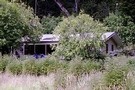
Nearby
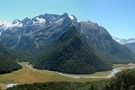
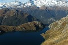
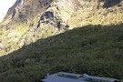
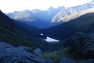
Lake Sylvan
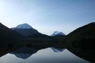
Lake Sylvan
Photograph
•
Distance: less than 100m away
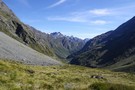
A calm forested lake in the Dart Valley near Glenorchy.
More ▶︎

Haast to The Divide
GPX file
•
Distance: less than 100m away
Andrew Barker's traverse 2009. From Pleasant Flat in the Haast to The Divide via Mt Aspiring National Park.
More ▶︎

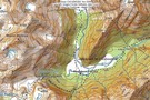
Five Passes via Lake Nerine and North Col
Article
•
Distance: less than 100m away
A classic tramp north of the Routeburn. Rather than exit via the Rockburn, we extended the trip through Lake Nerine ...
More ▶︎
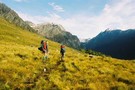
Five Passes
Track
•
6 – 7 days. Medium/hard. Loop track.
•
Distance: 106m away
A classic trip starting and finishing at the Routeburn road.
The five passes are; Sugarloaf pass, Park pass, Cow saddle, Fiery ...
More ▶︎
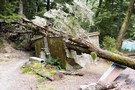
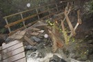
Broken bridge
Photograph
•
Distance: 2.9km away
The bridge at the start of the Routeburn Track, damaged by a slip, August 2008.
More ▶︎
Lake Wilson and the Valley of the Trolls
Track
•
2 – 3 days. Medium. Return by the same track.
•
Distance: 2.9km away
An overnight or multiday scenic diversion from the Routeburn Great Walk. The Valley of the Trolls is easily accessed from ...
More ▶︎
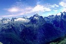
Parorama from Harris Saddle
Photograph
•
Distance: 2.9km away
several photographs put together to create a panoramic view
More ▶︎
Routeburn Track
Track
•
2 – 4 days. Easy/medium. One way.
•
Distance: 2.9km away
An internationally renowned and popular alpine crossing between Fiordland and Lake Wakatipu.
More ▶︎
The Serpentine Range and the Three Passes
Article
•
Distance: 2.9km away
A six day trip around the Three Passes, including a traverse of the Serpentine Range instead of the North Route ...
More ▶︎
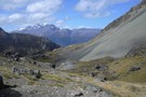
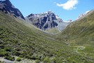
Lake Whakatipu from Sugarloaf
Photograph
•
Distance: 3.3km away
On the five passes route. Lake Whakatipu from just above Sugarloaf pass. taken Jan 2010
More ▶︎
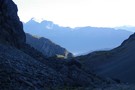
Harris Saddle Old Emergency Shelter
Photograph
•
Distance: 3.3km away
This old Emergency Shelter on Harris Saddle (1277m) is now replaced by something larger/better. This picture is from 2 November ...
More ▶︎
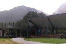
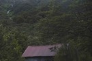
Routeburn Shelter
Photograph
•
Distance: 3.3km away
another rainy day at the start of the Routeburn (April 2009)
More ▶︎
Routeburn Shelter
Hut
•
Shelter (DOC).
•
Distance: 3.3km away
Enclosed shelter at the Wakatipu end of the Routeburn Track. Overnight use prohibited.
More ▶︎
Rockburn - Lake Nerine - North Routeburn
Track
•
3 – 5 days. Medium. Loop track.
•
Distance: 3.3km away
A slightly shorter option to the 5 passes trip but of similar if not more difficulty. Can be done in ...
More ▶︎
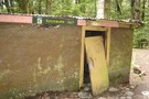
Rockburn Hut
Photograph
•
Distance: 3.8km away
DOC advises that the Rockburn Hut is closed "due to adverse weather conditions"
.... and a fairly solid tree !
More ▶︎
Rockburn Hut
Hut
•
Basic Hut/Bivvy (DOC). Capacity: 4.
•
Distance: 3.9km away
Rockburn Hut or McIntyres Hut. Near the confluence of Rock Burn and Dart River. A very rough and uninviting hut. ...
More ▶︎
Scott Saddle route (Dart to Caples)
Track
•
1 – 2 days. Medium. One way.
•
Distance: 3.9km away
This route crosses the easiest pass from the Dart to Caples Valleys, via Scott Creek, Scott Saddle and Kay Creek ...
More ▶︎
Not The Routeburn
GPX file
•
Distance: 4.0km away
A six-passes, seven catchments trip through the Humboldt Mountains from Glenorchy to The Divide.
Note that for access from Double Barrel ...
More ▶︎
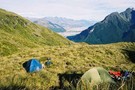
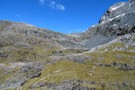
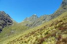
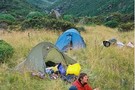
Camp on Sugarloaf Pass
Photograph
•
Distance: 4.1km away
A good way to start a trip going into the Rockburn is to leave Glenorchy late in the day and ...
More ▶︎
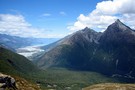
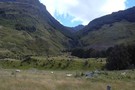
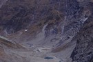
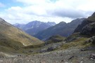
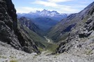
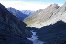
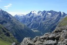
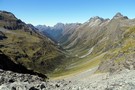
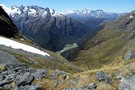
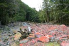
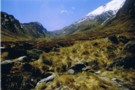
Looking up the Rockburn
Photograph
•
Distance: 4.2km away
From Sugarloaf pass, this is the view of the Rockburn that greets you after you cross
More ▶︎
Scott Creek Hut (removed)
Hut
•
Removed!
•
Distance: 4.9km away
Hut has been removed (2010?). Details below for old-time's sake ...
Scott Creek Hut (4 beds, fireplace, firewood available, creek water) ...
More ▶︎
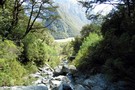
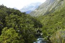
Dart River
Photograph
•
Distance: 5.4km away
looking down the Dart - about to head into the forest
Feb 2013
More ▶︎
Rees-Dart Track
Track
•
3 – 4 days. Medium/hard. Loop track.
•
Distance: 5.6km away
Alpine circuit along two river valleys at the head of Lake Wakatipu.
More ▶︎
Rees - Dart
GPX file
•
Distance: 5.6km away
Starting at Muddy Creek, this track heads up the Rees River to the head of the valley with a short ...
More ▶︎

Great Walks Information
Article
•
Distance: 5.9km away
The DOC Great Walks are a set of premium tramping tracks throughout New Zealand.
More ▶︎
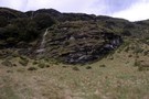
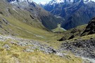
Scott Basin
Photograph
•
Distance: 6.0km away
Scott Basin at the head of Scott Creek, between the Dart and Caples valleys. Scott Creek Hut (dilapidated) is located ...
More ▶︎
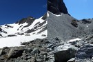
Scott Saddle
Photograph
•
Distance: 6.8km away
Scott Saddle (1450m) between Scott Creek and Kay Creek. This is the easiest pass between the Dart and Caples valleys. ...
More ▶︎
Scott Saddle
Photograph
•
Distance: 6.9km away
Scott Saddle (1450m) between Scott Creek and Kay Creek. This is the easiest pass between the Dart and Caples valleys. ...
More ▶︎
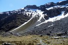
Double-Barrel - Fraser Pass
Photograph
•
Distance: 7.0km away
A steep, loose but otherwise straight forward pass out of the Double Barrel into the Fraser
More ▶︎
Death Valley Saddle
Photograph
•
Distance: 7.0km away
Death Valley is an offshoot of Kay Creek and makes an interesting and straight forward alternative to a crossing from ...
More ▶︎
beansburn track
Track
•
3 – 5 days. Medium. Return via same track.
•
Distance: 7.1km away
a route that follows the beansburn valley. lake unknown can be reached from here.
times:
beansburn mouth-rock bivvy no 1 1-1.5 ...
More ▶︎
Double Barrel from pass with the Fraser
Photograph
•
Distance: 7.1km away
Double Barrel Creek from the pass into the Fraser. Mt Earnslaw looking bare & bleak without snow cover in the ...
More ▶︎
Kay Lake and Death Valley Saddle
Photograph
•
Distance: 7.2km away
Death Valley is an offshoot of Kay Creek and makes an interesting and straight forward alternative to a crossing from ...
More ▶︎
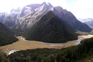
Dart Valley from Kay Saddle
Photograph
•
Distance: 7.3km away
Looking back down through Scott Basin to the Dart from Kay saddle
More ▶︎
Double Barrel Creek
Photograph
•
Distance: 7.3km away
Double Barrel Creek from the pass into Death Valley.
Catchment is blocked by twin falls at its lower end, but ...
More ▶︎
Death Valley from Saddle
Photograph
•
Distance: 7.4km away
Death Valley is an offshoot of Kay Creek and makes an interesting and straight forward alternative to a crossing from ...
More ▶︎
Matukituki to Paradise by roads less travelled
GPX file
•
Distance: 7.6km away
A rough, tough crossing from Raspberry Flat (Aspiring Road, Wanaka) to the Earnslaw Burn (Glenorchy-Paradise road) via Shotover Saddle, Lochnagar, ...
More ▶︎
Earnslaw Burn Rock Bivvy
Photograph
•
Distance: 7.8km away
Alternative rock bivvy from the biv shown on the topo map. This bivvy is on the true left of the ...
More ▶︎
Death Valley glacier (rems.)
Photograph
•
Distance: 7.8km away
Death of a glacier.
Death Valley, Humboldt Mountains
More ▶︎
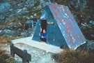
Earnslaw Burn Rock Bivvy
Rock bivouac
•
Distance: 7.8km away
This is an alternative bivvy to the one shown on topo maps. This bivvy is about 20 minutes upstream from ...
More ▶︎
Earnslaw Burn Rock Bivvy, underneath.
Photograph
•
Distance: 7.8km away
Underneath the Rock Bivvy. This one is about 20 minutes upstream from the official one on the top map and ...
More ▶︎
Routeburn Flats Hut
Hut
•
Great Walks Hut (DOC). Capacity: 20.Bookings required.
•
Distance: 7.9km away
A large hut on the Routeburn Track, often bypassed for the Routeburn Falls Hut which is 1 hour further along ...
More ▶︎
North Routeburn Rock bivvy
Photograph
•
Distance: 7.9km away
I've guessed the location from a description but don't take my word for it.
More ▶︎
North Route Burn Rock bivvy
Rock bivouac
•
Distance: 7.9km away
2 person biv rumoured to be 500m from the Routeburn Track in the North Branch of the Route Burn on ...
More ▶︎
Damaged bridge between Routeburn Falls and Routeburn Flats Huts
Photograph
•
Distance: 8.1km away
Photograph courtesy of DOC, I think. Around 30 April. Repairs not expected for about 3 months. This creek is easily ...
More ▶︎
Emily Creek
Photograph
•
Distance: 8.2km away
In Emily Creek looking down towards the bridge. Once you you get past the initial large boulders it's a typical ...
More ▶︎
Routeburn Flats
Campsite
•
Great Walks Campsite (DOC). 15 spaces.
•
Distance: 8.2km away
Grassy camping next to Routeburn Flats Hut.
More ▶︎
Routeburn
Photograph
•
Distance: 8.6km away
Taken from a slip below the Routeburn Falls hut (April 2009)
More ▶︎
Emily Basin from Fraser Col
Photograph
•
Distance: 8.6km away
Looking north from Fraser Col across Emily Basin.
January 2015.
More ▶︎
Fraser Creek
Track
•
1 – 2 days. Easy/medium. One way.
•
Distance: 8.6km away
One of several valleys that cut into the southern Humboldt Mountains. It passes through many kilometres of beech forest, river ...
More ▶︎
Fraser Valley from Fraser Col
Photograph
•
Distance: 8.6km away
The view down the Fraser from just below the Col.
January 2015.
More ▶︎
Emily Basin
Photograph
•
Distance: 8.6km away
High above the Routeburn at the top of Emily Creek, about 1.5 hours climb from Emily Creek bridge. Fraser Col ...
More ▶︎
Death Valley
Photograph
•
Distance: 8.7km away
Death Valley is an offshoot of Kay Creek and makes an interesting and straight forward alternative to a crossing from ...
More ▶︎
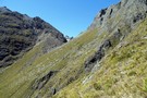
Fraser Col to Emily Pass Sidle.
Photograph
•
Distance: 8.9km away
This photo is looking east at Fraser Col from the true right top of the gut of the initial climb ...
More ▶︎
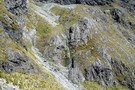
Route up to Emily Pass
Photograph
•
Distance: 8.9km away
This is looking west at the northern route up to Emily Pass, and is the opposite direction from this photo: ...
More ▶︎
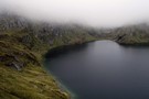
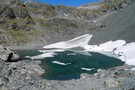
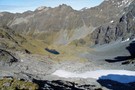
Lake Unknown
Photograph
•
Distance: 8.9km away
Lake Unknown lies high between the Beans Burn & the Rockburn. The Dart Valley is visible behind about 750 meters ...
More ▶︎
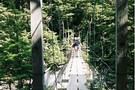
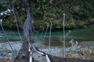
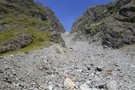
Bridge in the Rockburn
Photograph
•
Distance: 9.0km away
This fine bridge provides an easy crossing of the Rockburn just below Theatre Flat
More ▶︎
Emily Pass View
Photograph
•
Distance: 9.1km away
The view north from Emily Pass.
December 2014
More ▶︎
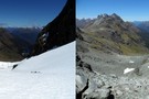
Emily Pass South View
Photograph
•
Distance: 9.1km away
What a difference a month makes.
Left photo mid December 2014. Right photo mid January 2015.
More ▶︎
Kay Creek - Upper Caples
Photograph
•
Distance: 9.1km away
April 2006 - Taken while coming back down Kay Creek to the Upper Caples DOC hut
More ▶︎
Hobbs Bivvy, Route Burn North Branch
Rock bivouac
•
Distance: 9.1km away
A dry and sheltered bivvy underneath a giant boulder in the North Branch of the Route Burn. Sleeps 4 or ...
More ▶︎
Hobbs Bivvy, Routeburn North Branch
Photograph
•
Distance: 9.1km away
Great dry bivvy located under a giant boulder in the north branch of the Routeburn. Sleeps 4 or 5 but ...
More ▶︎
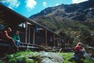
Routeburn Falls Hut
Hut
•
Great Walks Hut (DOC). Capacity: 48.Bookings required.
•
Distance: 9.1km away
A modern hut on the Routeburn track. It is at bushline on the edge of the cirque that leads up ...
More ▶︎
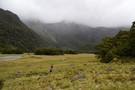
Theatre Flat
Photograph
•
Distance: 9.2km away
Approaching Theatre Flat from down valley. On a nice day it's a pleasant place to camp, not so much this ...
More ▶︎
Routeburn Falls hut
Photograph
•
Distance: 9.2km away
Routeburn Falls hut - great views (April 2009)
More ▶︎
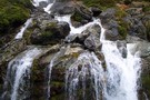
Routeburn Falls
Photograph
•
Distance: 9.2km away
Located near the Falls hut these impressive falls are passed on the way to Harris Saddle.
More ▶︎
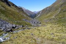
Theatre Flat
Photograph
•
Distance: 9.2km away
Half way up the Rockburn is the giant Theatre Flats. Lake Nerine is at the top of the bluffs at ...
More ▶︎
Key Summit
Photograph
•
Distance: 9.3km away
Key Summit from the Humboldts, looking towards the Earl Mountains. Kay Creek in the foreground
More ▶︎
Key Summit
Photograph
•
Distance: 9.3km away
Key Summit from the Humboldts, looking towards the Earl Mountains. Kay Creek in the foreground
More ▶︎
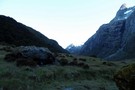
The North Branch of the Routeburn
Photograph
•
Distance: 9.3km away
Our final camp in the North Branch of the Routeburn. North Col, which we have just come through, is in ...
More ▶︎
Kay Creek Hut
Photograph
•
Distance: 9.4km away
Kay Creek Hut, between the Caples and Dart valleys.
More ▶︎
Emily Pass 1400m Basin
Photograph
•
Distance: 9.4km away
What a difference a month makes.
Left photo mid December 2014. Right photo mid January 2015.
More ▶︎
Old Routeburn Falls Hut 1989
Photograph
•
Distance: 9.4km away
The old Routeburn Falls Hut I stayed at in 2 November 1989 and 23 January 1990. Picture from November 1989. ...
More ▶︎
Rees Vally
Photograph
•
Distance: 9.5km away
This is a picture taken on the rees/dart track and is on day 2 of our tramp in between shelter ...
More ▶︎
Head of the Fraser Valley
Photograph
•
Distance: 9.6km away
This photo is taken from the site marked on the topo map where a rock bivy is supposed to exist. ...
More ▶︎
Kay Creek Hut
Hut
•
Basic Hut/Bivvy (DOC). Capacity: 3.
•
Distance: 9.8km away
Kay Creek Hut (sleeps 3-4, fireplace, firewood available, creek water) makes up for in character what it lacks in comfort. ...
More ▶︎
Kay Creek
Photograph
•
Distance: 9.8km away
Kay Creek, looking downstream from Kay Creek Hut
More ▶︎
Emily Pass 1200m Basin
Photograph
•
Distance: 9.8km away
There's great camping to be had in the large grassy basin at just over 1200m on the south side of ...
More ▶︎
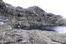
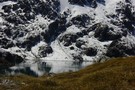
Lake Mackenzie
Photograph
•
Distance: 9.9km away
Lake MacKenzie from the basin below Emily Col. Good campspots and a so-so rock biv marked by a cairn.
More ▶︎