Nearby
Pelorus Track (via Rocks hut & Totara saddle)
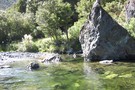
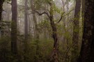
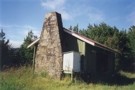
Pelorus
Track
•
3 – 4 days. Easy. One way.
•
Distance: 101m away
Links with a track onto Dun Mountain. See Rocks Hut-Pelorus Track.
More ▶︎
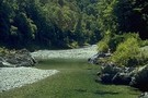
Rocks Hut - Pelorus Track
Track
•
2 days. Easy. One way.
•
Distance: 103m away
Continuing on from the Dun Mountain track, this route drops into the Pelorus Valley and sidles above its beautiful river. ...
More ▶︎
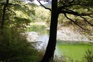
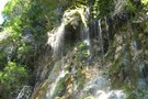
Emerald Pools
Track
•
Easy. Return via same track.
•
Distance: 163m away
A pretty picnic area and swimming hole upstream from Pelorus Bridge.
More ▶︎
Mt Richmond Alpine Route
Track
•
5 days. Medium. One way.
•
Distance: 683m away
Long route above the bushline in Mt Richmond Forest Park near Nelson.
More ▶︎
Hacket Circuit
Track
•
1 – 2 days. Easy/medium. Return via same track.
•
Distance: 1.9km away
A good day walk mainly along the Hacket Creek, including Hacket and Browning Huts. Dogs are allowed in the Mt ...
More ▶︎
The Swing bridge
Photograph
•
Distance: 1.9km away
When hiking the Hacket, after about 20-30 mins from the Aniseed Valley car park, a swing bridge must be crossed. ...
More ▶︎
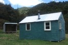
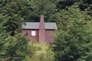
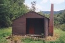
Browning Hut
Hut
•
Standard Hut (DOC). Capacity: 8.
•
Distance: 1.9km away
Water from the nearby creek. Nice and bright inside due to skylights. Some wasps and mosquitoes seen and mice suspected. ...
More ▶︎
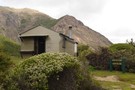
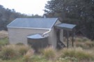
Hacket Hut
Hut
•
Standard Hut (DOC). Capacity: 6.
•
Distance: 4.0km away
This 6 bunk hut lies on the western edge of Mt Richmond Forest Park and is only 1½ hours walk ...
More ▶︎

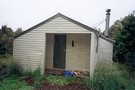
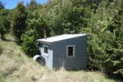
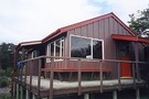
Hacket Hut
Photograph
•
Distance: 4.0km away
Another angle on this hut. Taken on New Year's Day 2005
More ▶︎
Mount Malita Hut
Hut
•
Basic Hut/Bivvy (NA).
•
Distance: 4.5km away
Hut near the summit of Mount Malita (959m) on the edge of Mount Richmond Forest Park. Not listed as a ...
More ▶︎
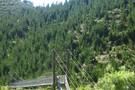
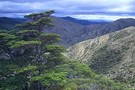
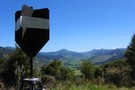
Edge of Nelson Mineral Belt May 2014
Photograph
•
Distance: 4.5km away
This photo taken from Windy Point on the Dun Mountain Walk/Cycleway looks South West. It was taken to illustrate the ...
More ▶︎
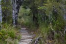
Whispering Falls walk/Hacket track
Track
•
0 – 1 day. Easy/medium. Return via same track.
•
Distance: 4.8km away
A gentle walk along the Hacket track to the beautiful Whispering Falls. Dogs permitted on leads.
More ▶︎
Whispering Falls
Photograph
•
Distance: 4.8km away
The "whisper" of the falls is created by the gentle trickling of the water
More ▶︎
Captains Creek Hut
Hut
•
Standard Hut (DOC). Capacity: 6.
•
Distance: 4.8km away
Captains Creek Hut
More ▶︎
Captain Creek Hut
Photograph
•
Distance: 4.8km away
Basic 4 bunker on the side of the Pelorus River, about 4 hours from road end, 3 from Emerald Pools, ...
More ▶︎
Roebuck Hut
Hut
•
Standard Hut (DOC). Capacity: 6.
•
Distance: 4.8km away
A remote, cosy hut in a great location (sandflies!) within the Richmond Forest Park near Nelson.
More ▶︎
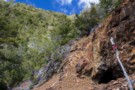
United Mine
Track
•
1 day. Easy/medium. Return by the same track.
•
Distance: 4.9km away
Walk to a smelter site and coppermine on the Roding River near Nelson.
More ▶︎
United Mine, No. 1 level.
Photograph
•
Distance: 4.9km away
These copper mines once kept 140 people employed.
More ▶︎
Roding River - Dun Mountain
Article
•
Distance: 4.9km away
My route through the Nelson Mineral Belt.
More ▶︎

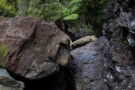
United Creek
Photograph
•
Distance: 5.1km away
Difficult creek upstream of the confluence with Jackson Creek.
More ▶︎
United Creek
Photograph
•
Distance: 5.1km away
Difficult creek upstream of the confluence with Jackson Creek.
More ▶︎
Didymo
Photograph
•
Distance: 5.5km away
Didymo coats the streambed. United Creek, Bryant Range, February 2013.
More ▶︎
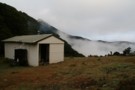
Starveall Hut (Richmond Ranges)
Photograph
•
Distance: 6.9km away
A tidy 6 bunk hut on the bushline in the Richmond Ranges.
Read my trip report on my blog http://waitakathlete.blogspot.co.nz/2017/07/solo-to-starveall.html
I couldn't ...
More ▶︎
Starveall Hut
Photograph
•
Distance: 7.1km away
Nicely situated hut overlooking Nelson and bay in the Richmond Forest Park.Nearby residents include a nosey woodhen who enjoys smelly ...
More ▶︎
Starveall Hut
Photograph
•
Distance: 7.2km away
This hut is in a top spot and has an Awesome View.
More ▶︎
Starveall Hut
Hut
•
Standard Hut (DOC). Capacity: 6.
•
Distance: 7.2km away
A standard DOC hut with six bunks and a wood burner situated on the bushline 45 minutes below the ridge ...
More ▶︎
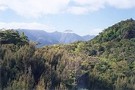
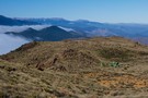
Morning trail
Photograph
•
Distance: 7.5km away
Leaving Rocks Hut on the way to Dun Mountain: an easy sidle.
More ▶︎
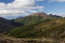
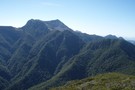
Dun Mountain
Track
•
2 days. Easy/medium. Return via same track.
•
Distance: 7.5km away
An historic climb along New Zealand's first railway onto the barren, toxic soils of the Nelson Mineral Belt.
More ▶︎
Rocks Hut Loop
Track
•
3 days. Medium. Loop track.
•
Distance: 7.5km away
A loop track starting at Rocks Hut in Mount Richmond Forest Park, taking in Dun Mountain and the Pelorus River.
More ▶︎
Route Guide: Loop from Rocks Hut
Article
•
Distance: 7.5km away
The well-appointed Rocks Hut in the Richmond Forest Park is a great start for a loop walk down through beech ...
More ▶︎
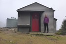
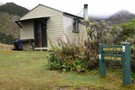
Rocks Hut
Hut
•
Serviced Hut (DOC). Capacity: 20.
•
Distance: 7.5km away
The most luxurious hut in the Richmond Forest Park. Flush toilets, great views, 4 sleeping platforms, wekas resident nearby (and ...
More ▶︎
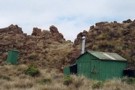
Dun Mountain Hut
Hut
•
Basic Hut/Bivvy (DOC). Capacity: 2.
•
Distance: 7.5km away
Really a shelter or bivouac but has water tank, stove and long drop (toilet).
More ▶︎
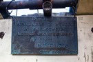
Sign inside Dun Mountain Hut
Photograph
•
Distance: 7.8km away
Dun Hut
Available to public in emergencies.
Advise undersigned of visit.
C. I. Kidson
city engineer
More ▶︎
Dun Mountain Hut
Photograph
•
Distance: 7.8km away
The little hut sits high on Dun Mountain.
More ▶︎
Slaty Hut
Hut
•
Standard Hut (DOC). Capacity: 6.
•
Distance: 7.9km away
On the Mt Richmond Alpine Route.
More ▶︎
Middy Hut
Hut
•
Standard Hut (DOC). Capacity: 6.
•
Distance: 8.2km away
Nice location but tons of sandflies on the river bank.
More ▶︎
Picton to Aspiring
GPX file
•
Distance: 8.5km away
An aborted alpine traverse. Picton to West Cape, but aborted at Aspiring due to real world emergencies back home. Posted ...
More ▶︎
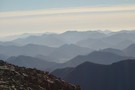
Walking the length of the Richmond Ranges
Track
•
7 – 14 days. Medium/hard. One way.
•
Distance: 9.1km away
A 7-14 day walk along the spine of the Richmond Ranges. Alpine tops, crumbling ridgelines, untracked bush & scrub, boulders ...
More ▶︎

Te Araroa Trail
Track
•
95 days. Medium. One way.
•
Distance: 9.2km away
Te Araroa is a walking trail running the entire length of the North and South Islands. The trail opened 3 ...
More ▶︎
Pelorus Bridge Trig K
Track
•
Easy. Loop track.
•
Distance: 9.3km away
A walk near the popular Pelorus Bridge. You'll walk in mature lush native bush, along the Pelorus River, and get ...
More ▶︎
Trig K at Pelorus Bridge
Photograph
•
Distance: 9.3km away
Trig K at Pelorus Bridge, DOc time 4 hours return to car park. Fit friend did the loop in 2 ...
More ▶︎
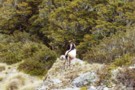
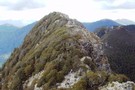
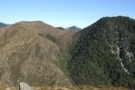
Richmond Range - country fit for mountain goats!
Photograph
•
Distance: 9.7km away
Goats rule on the main Richmond Range from Richmond Saddle to Ada Flats.
More ▶︎
Richmond Saddle Hut
Hut
•
Standard Hut (DOC). Capacity: 6.
•
Distance: 9.7km away
Hut near Mt. Richmond, on the saddle, nice view to Nelson Bay, and Abel Tasman. Beautiful sunset.
More ▶︎
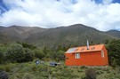
New Porters Creek Hut
Photograph
•
Distance: 9.9km away
moved to spot from right branch wairoa.
has beenlovingly restored with a new lick of 'rescue orange' paint and sports a ...
More ▶︎
Route Guide: Richmond Ranges (west) main ridge
Article
•
Distance: 9.9km away
The main ridge of the western Richmond Ranges from Mt Riley, near Okamario on SH6 to the Red Hills above ...
More ▶︎
Mt Fell from the North Bank
Track
•
2 days. Medium.
•
Distance: 9.9km away
A steady climb which rewards your efforts with fabulous views of the Wairau Plains, Nelson/Tasman Bay and beyond.
More ▶︎
Third House Hut
Hut
•
(DOC).
•
Distance: 9.9km away
Double sided open shelter. Overnight use prohibited.
More ▶︎