Nearby
Whitcombe Pass

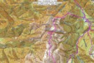
Route Guide: Otira to Mt Cook Village (pt 2)
Track
•
12 – 21 days. Hard. One way.
•
Distance: less than 100m away
One possible route down the main divide from Otira on the Arthur's Pass road to Mt Cook Village.
Otira Hotel ...
More ▶︎

Route Guide: Otira to Mt Cook Village (pt 1)
Track
•
12 – 21 days. Hard. One way.
•
Distance: less than 100m away
One possible route down the main divide from Otira on the Arthur's Pass road to Mt Cook Village.
Otira Hotel to ...
More ▶︎
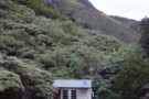
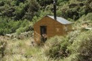
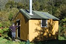
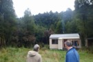
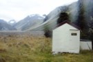
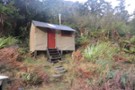
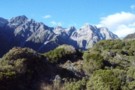
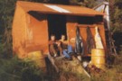
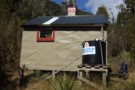
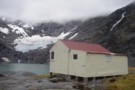
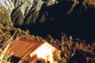
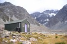
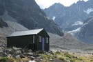
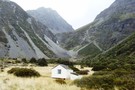
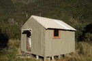
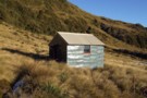
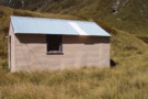
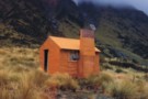
Reischek Hut
Photograph
•
Distance: less than 100m away
Reischek Hut, in the Raikaia valley below Butler Saddle.
More ▶︎
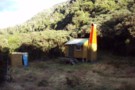
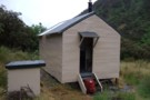
Reischek Hut
Hut
•
Basic Hut/Bivvy (NZDA). Capacity: 6.
•
Distance: less than 100m away
Reischek Hut (6-bunk, mattresses, stove, firewood, tank water, mountain radio) is a New Zealand Deer Stalkers Association (NZDA) hut on ...
More ▶︎
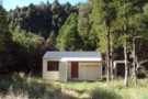
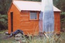
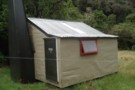
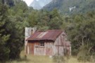
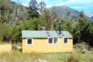
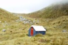
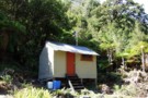
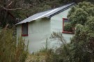
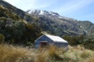
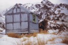
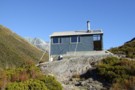
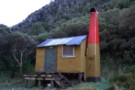
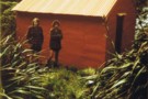
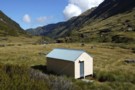
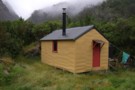
Frew Hut
Photograph
•
Distance: less than 100m away
Frew Hut, in the Whitcombe River valley, Westland
More ▶︎
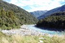
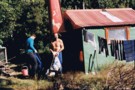
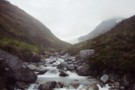
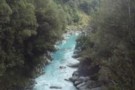
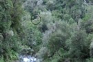
Whitcombe River from Frew Hut
Photograph
•
Distance: less than 100m away
Whitcombe River from Frew Hut, Westland
More ▶︎
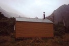
Frew Hut
Hut
•
Standard Hut (DOC). Capacity: 10.
•
Distance: less than 100m away
Frew Hut (sleeps 10 on 2 platforms, matresses, tank & creek water, stove) is a modern tramping hut on river ...
More ▶︎
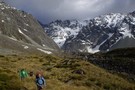
Whitcombe Pass & Butler Saddle
Article
•
Distance: less than 100m away
route guide attached by for Hokitika Gorge to Erewhon via Whitcombe Pass & Butler Saddle. The guide was written by ...
More ▶︎
Picton to Aspiring
GPX file
•
Distance: less than 100m away
An aborted alpine traverse. Picton to West Cape, but aborted at Aspiring due to real world emergencies back home. Posted ...
More ▶︎
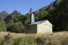
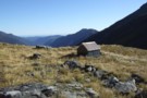
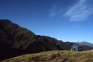
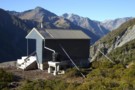
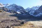
Neave Hut
Photograph
•
Distance: less than 100m away
Neave Hut, in the upper Whitcombe, Westland. The hut lies just 5km below the Whitcombe Pass intot he Raikaia.
More ▶︎
Neave Hut
Hut
•
Standard Hut (DOC). Capacity: 6.
•
Distance: less than 100m away
Neave Hut (6 bunks, matresses, stream water, stove, limited firewood) is a comfortable forestry-style hut in the upper Whitcombe Valley, ...
More ▶︎
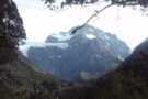
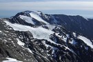
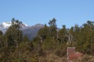
Mount Evans
Photograph
•
Distance: less than 100m away
Mt Evans, from Neave Hut in the upper Whitcombe Valley of Westland.
More ▶︎
Rapid Creek hut May 1975
Photograph
•
Distance: less than 100m away
An older pic of the hut after it had got its first replacement chimney. These days the hut has a ...
More ▶︎
Rapid Creek hut June 2008
Photograph
•
Distance: less than 100m away
This is a four bunker on the TL of the Hokitika River not far below the junction with the Whitcombe ...
More ▶︎
Rapid Creek hut
Hut
•
Basic Hut/Bivvy (DOC). Capacity: 4.
•
Distance: less than 100m away
This is a four bunker on the TL of the Hokitika River not far below the junction with the Whitcombe ...
More ▶︎
Wilkinson hut April 2012
Photograph
•
Distance: less than 100m away
This pic was taken last month when travelling from Prices Basin to Prices Flat. I needed to head up to ...
More ▶︎
Wilkinson hut reference / Nostalgia / History
Photograph
•
Distance: less than 100m away
I came across these hut book entries when searching the archived Frews hut book looking for info to support my ...
More ▶︎
Wilkinson hut 1993
Photograph
•
Distance: less than 100m away
This pic shows track cutters Kelvin and Merv outside Wilkinson hut in 1993. This photo was taken by mate JH.
More ▶︎
Wilkinson hut
Hut
•
Basic Hut/Bivvy (DOC). Capacity: 4.
•
Distance: less than 100m away
A 1950's era NZFS cullers hut on the TL of the Whitcombe River just over a km downstream from where ...
More ▶︎
Bruce Banfield Memorial Hut
Hut
•
Standard Hut (Canterbury Mountaineering Club). Capacity: 6.
•
Distance: 110m away
First built in 1946 in the Jagged Stream basin as a memorial to Bruce Banfield who died below White Col. ...
More ▶︎
Frews Hut
Photograph
•
Distance: 139m away
8/10 bunker,like the Hilton after Frews Bivvy.Overlooks the Whitcombe River & 200m west of Frews
Creek.We saw a pair of ...
More ▶︎
Mount Butler
Photograph
•
Distance: 156m away
Mount Butler from the Raikaia near Louper Biv / Reischek Hut
More ▶︎
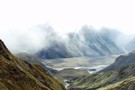
Raikaia River flats
Photograph
•
Distance: 156m away
Raikaia River flats between Louper Biv and Reischek hut
More ▶︎
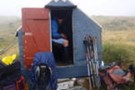
Louper Bivouac
Photograph
•
Distance: 156m away
Louper Bivvy in the Raikai below the Whitcombe Pass
More ▶︎
Louper Bivouac
Hut
•
Basic Hut/Bivvy (DOC). Capacity: 2.
•
Distance: 156m away
Louper Bivouac (2 beds, matresses, tank water) is a basic bivvy on the flats of the north bank of the ...
More ▶︎
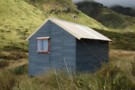
Prices Flat Hut (historic)
Photograph
•
Distance: 170m away
Prices Flat Hut (historic) - in the Whitcombe Valley, Westland. A place full of character, and full of sandflies. A ...
More ▶︎
Prices Flat Hut (historic)
Hut
•
Basic Hut/Bivvy (DOC). Capacity: 4.
•
Distance: 170m away
The historic Prices Flat Hut is better looked at than slept in. It is a beutiful slab hut, with an ...
More ▶︎
Historic Price Flat Hut
Hut
•
Basic Hut/Bivvy (DOC). Capacity: 4.
•
Distance: 184m away
Slab hut once used for deer culling and possibly dating to 1908. The hut is located next to the newer ...
More ▶︎
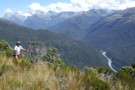
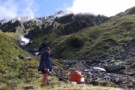
Upper Whitcombe River at Neave Hut
Photograph
•
Distance: 288m away
The upper Whitcombe River at Neave Hut, just 5km from its headwaters at the Whitcombe Pass. The track to the ...
More ▶︎
Price Flat Hut
Hut
•
Standard Hut (DOC). Capacity: 6.
•
Distance: 303m away
Prices Flat Hut (6 bunks, matresses, tank water, stove) lies on a small terrace 100m above the Whitcombe River, adjacent ...
More ▶︎
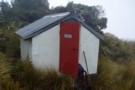
Prices Flat Hut
Photograph
•
Distance: 303m away
The new(er) Prices Flat Hut, in the Whitcombe Valley, Westland.
More ▶︎
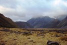
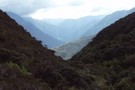
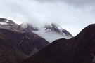
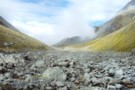
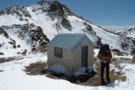
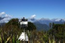
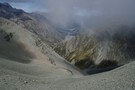
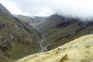
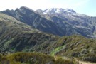
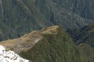
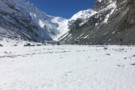
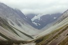
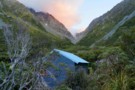
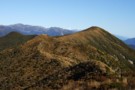
Whitcombe Pass
Photograph
•
Distance: 337m away
Whitcombe Pass - between the Whitcombe and Raikaia catchments. The Louper Stream descends 7km from this point to the flats ...
More ▶︎
Toaroaha Saddle-Frew Saddle Circuit
Track
•
4 – 6 days. Medium. One way.
•
Distance: 424m away
A great tramp in a remote location, crosses two alpine saddles, ice-axes and crampons needed in winter. More information on ...
More ▶︎
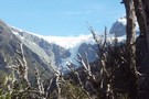
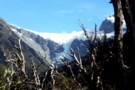
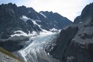
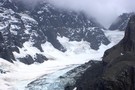
Bracken Snowfield / Wilkinson Glacier
Photograph
•
Distance: 619m away
Bracken Snowfield / Wilkinson Glacier, from the Prices Flat - Wilkinson Hut track. In the Whitcombe River valley, Westland.
More ▶︎
Cave Camp
Rock bivouac
•
Distance: 911m away
Located on the Whitcombe Track, on river flats just beneath the confluence with the Wilkinson River. The biv affords a ...
More ▶︎
Wilkinson Glaciers
Photograph
•
Distance: 1.4km away
Glaciers descend from the Bracken Snowfield accross the valley from the track from Prices Flat to Neave Hut in the ...
More ▶︎
Hokitika Gorge
Track
•
Easy. Return by the same track.
•
Distance: 1.5km away
A short walk near Hokitika, crossing the glacial-blue waters of the Hokitika River.
More ▶︎
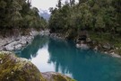
Hokitika River (Bottom Gorge)
Photograph
•
Distance: 1.5km away
This photo looks upstream from 5 minutes above the swingbridge at the Hokitika Gorge. (The furthest downstream & closest to ...
More ▶︎
View up Whitcombe from Meta Range Feb 2011
Photograph
•
Distance: 2.4km away
This pic looks out over Frews Ck and up the Whitcombe River to those famed spots of hunting folklore The ...
More ▶︎
Mt Misery & beyond February 2013
Photograph
•
Distance: 2.7km away
Last month I decided to climb a hill that can be seen from home that I'd never got around to ...
More ▶︎
Bevernage Biv
Rock bivouac
•
Distance: 2.7km away
Small overhangs that are reportedly next to useless. Located on Seddon Creek near an ice lake below Mount Evans.
A ...
More ▶︎
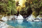
Whitcombe River gorge
Photograph
•
Distance: 2.8km away
Whitcombe River gorge, upstream from Frew Hut
More ▶︎
View SE along the Meta Range March 2011
Photograph
•
Distance: 3.2km away
This picture was taken from near the summit of Mt Inframeta & looks along the Meta Range toward the Southern ...
More ▶︎
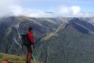
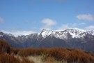
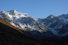
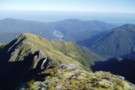
Butler Saddle
Photograph
•
Distance: 3.3km away
Butler Saddle from Reischek Stream. The saddle is the scree-covered col to the left of the ridge in the centre.
More ▶︎
Boulder Col from Washbourne Ck to Jagged Stream
Article
•
Distance: 3.6km away
Nine hour circuit with good view of Reishek Glacier.
More ▶︎
Price Basin hut
Hut
•
Basic Hut/Bivvy (DOC). Capacity: 4.
•
Distance: 3.7km away
This hut, which is usually known as Price(s) Basin, is located on the TL of the TR branch of the ...
More ▶︎
Frew Creek
Photograph
•
Distance: 4.1km away
Frew Creek, flowing into the Whitcombe, Westland
More ▶︎
Observation Col
Photograph
•
Distance: 4.3km away
Technically easy, but does require crampons and axe. Approached from South Mathias Biv, bivvied under Col, went down Cattle Stream ...
More ▶︎
packrafting trip from upper Rakia to Erewhon Station
Video
•
Distance: 4.7km away
Climbing over Butler Saddle and packrafting down Lawrrence and Clyde Rivers to Erwehon Station in December 2008
More ▶︎
Evans Hut
Hut
•
Basic Hut/Bivvy (NZDA). Capacity: 6.
•
Distance: 4.8km away
Hut located at Cattle Stream on the Rakaia River.
More ▶︎
Butler Saddle and the Lawrence Valley
Photograph
•
Distance: 4.8km away
The view down the Lawrence Valley from Butler Saddle. This is an alpine route from The Raikaia into the Lawrence, ...
More ▶︎
Raikaia from the Butler Saddle
Photograph
•
Distance: 4.8km away
Raikaia River flats, from the Butler Saddle. This is an alpine route from the Raikaia to the Lawrence / Clyde ...
More ▶︎
Mt Chamberlain
Photograph
•
Distance: 5.0km away
Mt. Chamberlain, from the ridgeline above Kokatahi Bivouac
More ▶︎
Lyell Hut
Hut
•
Club hut (Canterbury Mountaineering Club). Capacity: 8.
•
Distance: 5.0km away
This hut is located high on the Rakaia River near the foot of the Lyell Glacier.
More ▶︎
serpentine hut
Photograph
•
Distance: 5.1km away
Flew into hut to drop a group of 6 off they were going to stay the night and walk out
More ▶︎
Frew Saddle Bivouac / Frew's Biv
Hut
•
Basic Hut/Bivvy (DOC). Capacity: 2.
•
Distance: 5.1km away
The Frew Saddle Bivouac (sleeps 2, matresses, stream water 100m distant, no fire) is a well maintained alpine bivouac 200m ...
More ▶︎
Frew Saddle Bivouac
Photograph
•
Distance: 5.1km away
Frew Saddle Bivouac, between the Whitcombe and Hokitika valleys in Westland.
More ▶︎
Looking NW over Frew biv April 2011
Photograph
•
Distance: 5.1km away
This pic looks over top of the biv down Frew Creek to the Whitcombe and on out to the coast. ...
More ▶︎
Serpentine hut setting March 2011
Photograph
•
Distance: 5.1km away
This picture from approx 300 metres away across the Hoki River shows Serpentine huts location on an overgrowing clearing on ...
More ▶︎
Serpentine hut
Hut
•
Basic Hut/Bivvy (DOC). Capacity: 4.
•
Distance: 5.1km away
This hut is located on a small bush terrace on the TR of the Hokitika River and the TL of ...
More ▶︎
Serpentine Hut 1977
Photograph
•
Distance: 5.1km away
This photo of Serpentine hut was taken summer time 1977 by friend & sometimes tramping companion Neil Bradley.
The access route ...
More ▶︎
Serpentine Hut March 2015
Photograph
•
Distance: 5.1km away
Here is a recent photo of this survivor built in 1957 for deer culler accomodation. Andrew Buglass and "Permolat" helpers ...
More ▶︎
Frews Biv
Photograph
•
Distance: 5.1km away
little (officially anyway) two man job on Frews Saddle
More ▶︎
Whitcombe/Frews Saddle/Bluff Hut/Homeward Spur/Toaroha Saddle/Crystal Biv/Cedar Flats
Article
•
Distance: 5.2km away
a five day circuit
More ▶︎
Upper Hokitika River from Frew Saddle
Photograph
•
Distance: 5.3km away
Tussock hides the ubiquitous speargrass in the upper reaches of the Hokitika, giving the illusion of an easy, pleasant tramp.
More ▶︎
Mt Bowen from Fraser Peak March 2013
Photograph
•
Distance: 5.6km away
This photo of Mt Bowen 1965m was taken from near the summit of Fraser Peak 1166m. Both peaks lie between ...
More ▶︎
Looking SW from Mt Diedrichs May 2013
Photograph
•
Distance: 5.6km away
This photo taken from beside the trig beacon on the summit of Mt Diedrichs 1084m looks SW over the Hokitika ...
More ▶︎
View SE from Bald Hill Range June 2013
Photograph
•
Distance: 5.6km away
This picture was taken from the crest of the Bald Hill Range NE of Bald Hill.
The tussock and low ...
More ▶︎
Packrafting trip from Bealey to upper Rakaia River
Video
•
Distance: 5.7km away
A video of a hiking and packrafting trip up over Jordan saddle, down the Avoca, Harper, and Wilberforce Rivers, then ...
More ▶︎
Waimakariri to Rakaia
Video
•
Distance: 5.7km away
Video showing hike up the Waimakariri, over Jordan Pass, with a packraft down the Avoca and then walking up Rakaia ...
More ▶︎
Frisco hut Jan 2009
Photograph
•
Distance: 6.0km away
Frisco hut is on the TR of the Hokitika River less than 2kms below the junction with the Mungo River. ...
More ▶︎
Frisco hut
Hut
•
Basic Hut/Bivvy (DOC). Capacity: 4.
•
Distance: 6.0km away
Frisco hut is on the TR of the Hokitika River less than 2kms below the junction with the Mungo River. ...
More ▶︎
Explorer Hut
Hut
•
Basic Hut/Bivvy (DOC). Capacity: 4.
•
Distance: 6.3km away
A small hut located near Douglas Saddle.
Easiest access is from the Mikonui valley. None of the routes are recommended in ...
More ▶︎
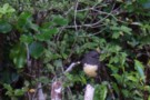
SI Bush Robin
Photograph
•
Distance: 6.3km away
This friendly bird kept me company at Explorer hut the couple of nights I was there recently. It would come ...
More ▶︎
Explorer hut Sept 2007
Photograph
•
Distance: 6.3km away
Explorer hut Douglas Saddle. Mikonui River/Doctors Creek (a tributary of the Hokitika River)
More ▶︎
Looking up Mikonui Spur Dec 2010
Photograph
•
Distance: 6.4km away
This pic is taken from the track on the spur below the biv and looks up past the biv in ...
More ▶︎
Mikonui Spur biv Dec 2010
Photograph
•
Distance: 6.4km away
A pic of the biv with Mt Bowen behind to the SE.
More ▶︎
Mikonui Spur Bivvy
Hut
•
Basic Hut/Bivvy (DOC). Capacity: 2.
•
Distance: 6.4km away
A traditional forestry bivvy that has braved many a Tasman Sea storm, on an exposed ridge top above the Mikonui ...
More ▶︎
Mikonui Spur biv Nov 2007
Photograph
•
Distance: 6.4km away
The subject J H & photographer, not me in this case, Horse G are sometimes tramping companions. They, like myself, ...
More ▶︎
Cameron Glacier
Photograph
•
Distance: 6.5km away
Cameron Glacier, Arrowsmith Range. taken March 2008.
More ▶︎
Mt Beaumont (2131m) April 2012
Photograph
•
Distance: 6.6km away
This pic looks at Mt Beaumont from the south and was taken from the crest of the Lange Range while ...
More ▶︎
"New" Gerhardt Spur biv June 1975
Photograph
•
Distance: 6.7km away
This pic shows DH at the then fairly new Gerhardt Spur biv on Queens Birthday weekend 1975. Mt Jumble Top ...
More ▶︎
Looking down at Gerhardt Spur biv from Jumble Top May 2009
Photograph
•
Distance: 6.7km away
Gerhardt Spur biv is an early/mid 1970's era NZFS biv located in the tussock high on Gerhardt Spur which is ...
More ▶︎
Gerhardt Spur biv
Hut
•
Basic Hut/Bivvy (DOC). Capacity: 2.
•
Distance: 6.7km away
An early/mid 1970's era NZFS biv located in the tussock high on Gerhardt Spur which is on the western side ...
More ▶︎
Ivory Lake Hut
Hut
•
Basic Hut/Bivvy (DOC). Capacity: 6.
•
Distance: 6.7km away
An old Meteorological Service hut located in a picturesque location at the head of the Waitaha Valley. No toilet. A ...
More ▶︎
Gerhardt Spur
Photograph
•
Distance: 6.8km away
A crystal clear morning at Gerhardt Spur Bivvy
More ▶︎
"Old" Bluff Hut (has been relocated & upgraded)
Hut
•
Removed!
•
Distance: 6.9km away
Ex NZFS 4 person hut. Shifted by DOC in 2009 further upvalley. Following notes are historical.
The water supply is currently ...
More ▶︎
"Old" Bluff hut (Removed) 1974
Photograph
•
Distance: 6.9km away
This is the "old" Bluff hut that has been shifted to the new site & upgraded. We will visit the ...
More ▶︎
"New" Bluff hut April 2011
Photograph
•
Distance: 6.9km away
This square on shot of the new hut is from the perspective of looking up the TL of the Hokitika ...
More ▶︎
"New" Bluff hut & Mungo valley April 2011
Photograph
•
Distance: 6.9km away
The old Bluff hut was dismantled and moved about 150 metres in 2010. At the same time it got a ...
More ▶︎
The bluff on the upper Hokitika River just above the Mungo confluence
Photograph
•
Distance: 6.9km away
This pic taken in 2009 before Bluff hut was shifted and upgraded shows the setting of the hut from the ...
More ▶︎
"New" Bluff Hut
Hut
•
Standard Hut (DOC). Capacity: 6.
•
Distance: 6.9km away
The old Bluff hut was dismantled and moved about 150 metres in 2010. At the same time it got a ...
More ▶︎
Western flanks of Mt Ross
Photograph
•
Distance: 7.1km away
This pic was taken when MM & I stopped to boil the billy having descended from Mt Ross(1770m) en route ...
More ▶︎

Cameron upper valley
Photograph
•
Distance: 7.3km away
The upper Cameron valley showing the Cameron glacier and Arrowsmith range. taken March 2008.
More ▶︎
Cameron Glacier
Photograph
•
Distance: 7.6km away
Can be viewed an hour or two up behind the Cameron hut.
More ▶︎
Jumbletop
Photograph
•
Distance: 7.7km away
Near the summit of Mt Jumbletop at sunrise. View to Mt Evans and Sentinal
More ▶︎
Remarkable Peak
Photograph
•
Distance: 7.9km away
This photo shows Remarkable Peak 1790m in spring conditions. It is the tooth like peak centre picture. The pic was ...
More ▶︎
Cameron Hut
Photograph
•
Distance: 7.9km away
5-6 hours walking up the Cameron Valley, not far from Lake Heron.
More ▶︎
cameron hut
Photograph
•
Distance: 7.9km away
the peaks above the flats between the moraine walls at the head of the Cameron river, including the Cameron Hut. ...
More ▶︎
Jumble Tops Traverse
Photograph
•
Distance: 8.2km away
A GPS track of Doug Forster's traverse of Jumble Tops in pink. 3 of us did a more direct version ...
More ▶︎
West Mathias Bivvy
Hut
•
Basic Hut/Bivvy (DOC). Capacity: 2.
•
Distance: 8.2km away
Small hut near the confluence of the South and West Mathias Rivers.
More ▶︎
Cameron Hut (Rangitata/Rakaia)
Hut
•
Basic Hut/Bivvy (DOC). Capacity: 9.
•
Distance: 8.2km away
Located close to Arrowsmith Range at the head of the Cameron River valley. This is a Canterbury Mountaineering Club Hut, ...
More ▶︎
Double Crossing of the Wild Man Brothers Range
Article
•
Distance: 8.2km away
A 3 day trip going from the head of the Cameron River in the Hakatere over the above range to ...
More ▶︎
Healey Spur Feb 2014
Photograph
•
Distance: 8.5km away
This photo shows the last steep bit of Healey Spur before reaching the relatively easy going of Galena Ridge at ...
More ▶︎
Upper Lawrence Valley
Photograph
•
Distance: 8.5km away
The upper Lawrence Valley and the Lawrence Glacier, from Lawrence Biv.
More ▶︎
Lawrence Bivouac
Photograph
•
Distance: 8.5km away
Lawrence Bivouac, a small 2-man biv in the upper Lawrence River, Canterbury. The falls at Hells Gates are visible behind.
More ▶︎
Lawrence Bivouac
Hut
•
Basic Hut/Bivvy (DOC). Capacity: 2.
•
Distance: 8.5km away
Lawrence Bivouac (sleeps 2 on floor, matresses, stream water) is a small but weatherproof bivouac in the upper Lawrence Valley. ...
More ▶︎
Cameron river view
Photograph
•
Distance: 8.6km away
The main peaks of the Arrowsmith range, as seen from the middle Cameron valley, 2hrs from the road.
More ▶︎
Mullins Basin April 2008
Photograph
•
Distance: 8.9km away
This pic shows the huts location in the basin and shows part of the imposing Diedrich Range behind.
More ▶︎
Mullins Basin hut April 2008
Photograph
•
Distance: 8.9km away
Mullins Basin hut is a four bunk hut situated in the head basin of Mullins Creek a TL tributary of ...
More ▶︎
Mullins Basin hut
Hut
•
Basic Hut/Bivvy (DOC). Capacity: 4.
•
Distance: 8.9km away
A four bunk hut situated in the head basin of Mullins Creek a TL tributary of the Toaroha River. The ...
More ▶︎
Southern Alps from Homeward Ridge
Photograph
•
Distance: 9.1km away
Southern Alps from Homeward Ridge - opposite Poet Hut, above the Mungo / Hokitika valley.
More ▶︎
Healey Creek hut May 2008
Photograph
•
Distance: 9.2km away
A tidy four bunker toward the head of Healey Creek a Mikonui River tributary. The hut is on a tussock ...
More ▶︎
Healey Creek hut
Hut
•
Basic Hut/Bivvy (DOC). Capacity: 4.
•
Distance: 9.2km away
A tidy four bunker toward the head of Healey Creek a Mikonui River tributary. The hut is on a tussock ...
More ▶︎
Poet hut April 2011
Photograph
•
Distance: 9.2km away
This hut is a 1950's NZFS cullers hut located on the TR of the Mungo River a tributary of the ...
More ▶︎
Poet Hut
Hut
•
Standard Hut (DOC). Capacity: 4.
•
Distance: 9.2km away
Poet Hut (4 bunks, matresses, fireplace, river water) is a timber built hut in a small clearing in the Mungo ...
More ▶︎
Poet Hut
Photograph
•
Distance: 9.2km away
Poet Hut, a riverside hut in the Mungo / Hokitika valley.
More ▶︎
Sir Robert hut 1974
Photograph
•
Distance: 9.3km away
This hut is located on the TL near the stream in the head basin of Sir Robert Creek. The hut ...
More ▶︎
Sir Robert hut
Hut
•
Basic Hut/Bivvy (DOC). Capacity: 4.
•
Distance: 9.3km away
This hut is located on the TL near the stream in the head basin of Sir Robert Creek. The hut ...
More ▶︎
Sir Robert Hut 2012
Photograph
•
Distance: 9.3km away
One of the more remote, seldom visited huts in Westland. The log book with barely half a dozen pages goes ...
More ▶︎
Black Hut Totara Valley & beyond
Photograph
•
Distance: 9.4km away
This July shot taken from beside the Totara Valley road shows Black Hut. The higher country in the back ground ...
More ▶︎
Looking SW along the Bald Hill Range June 2013
Photograph
•
Distance: 9.4km away
This photo shows the easy tussock tops of the Bald Hill Range. Bald Hill is the tussocky high point down ...
More ▶︎
Mungo River pools above Poet Hut
Photograph
•
Distance: 9.4km away
Mungo River pools 200m upstream of Poet Hut
More ▶︎
Top Waitaha hut March 2012
Photograph
•
Distance: 9.6km away
This hut is an NZFS six bunker that was built in 1968. It has no open fire or stove. There ...
More ▶︎
Top Waitaha hut
Hut
•
Basic Hut/Bivvy (DOC). Capacity: 6.
•
Distance: 9.6km away
This hut is an NZFS six bunker that was built in 1968. It has no open fire or stove. There ...
More ▶︎
Smythe River
Photograph
•
Distance: 9.7km away
Strenuous travel up Smythe River, crossing from the Wanganui River to the Waitaha River, Westland
More ▶︎
Smyth hut January 2012
Photograph
•
Distance: 9.8km away
Smyth hut is an ex NZFS six bunk hut in the upper Wanganui River area in Westland. It is on ...
More ▶︎
Smyth hut
Hut
•
Standard Hut (DOC). Capacity: 6.
•
Distance: 9.8km away
Smyth hut is an ex NZFS six bunk hut in the upper Wanganui River area in Westland. It is on ...
More ▶︎
Top Tuke hut Dec 1975
Photograph
•
Distance: 9.8km away
This four bunk hut is located on the TR in the head basin of the Tuke River a tributary of ...
More ▶︎
Top Tuke hut
Hut
•
Basic Hut/Bivvy (DOC). Capacity: 4.
•
Distance: 9.8km away
This four bunk hut is located on the TR in the head basin of the Tuke River a tributary of ...
More ▶︎
Top Tuke hut March 2012
Photograph
•
Distance: 9.8km away
Here is a photo of this hut from a different angle than the 1975 one I posted and "major's" one ...
More ▶︎
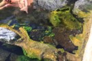
Smyth hot pools
Photograph
•
Distance: 9.9km away
Interesting algae. Water temperature about 38C.
More ▶︎
Top Toaroha hut Jan 2009
Photograph
•
Distance: 10.0km away
This hut is located on the Bannatyne Flats towards the head of the Toaroha River. It is on the main ...
More ▶︎
Top Toaroha hut
Hut
•
Standard Hut (DOC). Capacity: 6.
•
Distance: 10.0km away
This hut is located on the Bannatyne Flats towards the head of the Toaroha River. It is on the main ...
More ▶︎