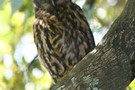
Nearby
Morepork

Goldie Bush Walkway
Track
•
Easy. One way.
•
Distance: 565m away
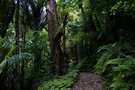
A brief trail through dry kauri forest.
More ▶︎
Goldies Bush - Mokoroa Stream Circuit
Track
•
Easy/medium. Loop track.
•
Distance: 565m away
An excellent loop route through Goldies Bush Scenic Reserve, exploring both damp and dry forest, and visiting a waterfall.
More ▶︎
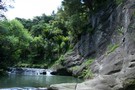
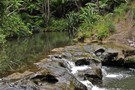
Mokoroa Stream Track
Photograph
•
Distance: 707m away
Edging around rocky ledges at the edge of the stream.
More ▶︎
Mokoroa Stream track
Photograph
•
Distance: 1.7km away
Lots of tree ferns and nikau palms. Lush and very seldom out of view of the stream. We enjoyed a ...
More ▶︎
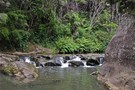
Mokoroa Stream track
Photograph
•
Distance: 1.7km away
Lovely stream walk. Rocks were very slippery.
More ▶︎
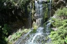
Houheria Stream Falls
Photograph
•
Distance: 1.7km away
Mokoroa and Houheria Stream Falls goth tumble into the same dusty amphitheatre.
More ▶︎
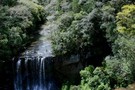
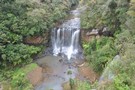
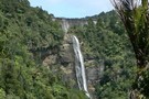
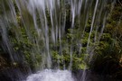
Mokoroa Falls
Photograph
•
Distance: 1.7km away
11m falls at the head of the Mokoroa Stream Track.
More ▶︎
Mokoroa Falls Track
Track
•
Easy. Return via same track.
•
Distance: 1.7km away
Good views of the 11m Mokoroa Falls.
More ▶︎
Mokoroa Stream Track
Track
•
Easy/medium. One way.
•
Distance: 1.7km away
A lush forest trail criss-crossing the Mokoroa Stream and leading to the foot of the Mokoroa Falls.
More ▶︎
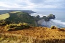
Te Henga Walkway - from Bethells Beach, Waitakere
Track
•
Easy. Return via same track.
•
Distance: 3.4km away
Ok. Are you ready to be blown away?
Maybe literally - choose your day!
Take this one as seriously as you like ...
More ▶︎

Hillary Trail
Track
•
4 – 6 days. Medium. One way.
•
Distance: 3.8km away
A spectacular coastal walk in the Waitakere Ranges west of Auckland.
ALOT OF THIS TRAIL IS CLOSED FOR KAURI DIE BACK ...
More ▶︎
Pae o te Rangi Campground
Campsite
•
Basic Campsite (Private). 30 spaces.
•
Distance: 4.7km away
Pae o te Rangi is a campsite in the Kauri Cascades area of Auckland's Waitakere Ranges.
Managed by Auckland Council. Bookings ...
More ▶︎
Montana Heritage Trail
GPX file
•
Distance: 6.3km away
Circuit track touring the Ark in the Park in the Waitakere Ranges.
More ▶︎
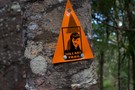
Hillary Trail marker
Photograph
•
Distance: 6.3km away
A marker nailed into a kauri tree on the Upper Kauri Track.
More ▶︎
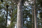
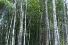
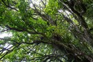
Kauri stand, Waitākere Ranges.
Photograph
•
Distance: 6.3km away
The Upper Kauri Track at Cascade Kauri Park winds through this beautiful kauri stand.
More ▶︎
Auckland City Walk
Photograph
•
Distance: 6.6km away
Short walk in the heart of the Waitakere Ranges.
More ▶︎
Waitakere Dam, tunnels and Anawhata Stream Loop
Track
•
0 – 1 day. Easy. Loop track with a road section.
•
Distance: 7.4km away
Waitakere Dam, tunnels and Anawhata Stream Loop
This 4.5 hour walk takes you through kauri forest, ferny-edged streams, up and along ...
More ▶︎
Waitakere Ranges Regional Park
Place
•
Place. 170.00km2.
•
Distance: 7.5km away
The largest regional park managed by Auckland Council, this park covers 17000 hectares of rich and diverse forests, as well ...
More ▶︎
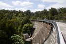
Waitakere Dam
Photograph
•
Distance: 7.8km away
One of the water supply dams of the Waitakere Ranges.
More ▶︎
Montana Heritage Trail- Waitakere Ranges
Track
•
Easy. Loop track.
•
Distance: 7.8km away
A beaut walk in kauri forest, from the Cascades carpark. A good introductory tramp in a half day. Take your ...
More ▶︎
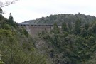
Waitakere Dam and Falls
Photograph
•
Distance: 7.9km away
The Waitakere Dam was completed 1910 over the top of the Waitakere Falls (95m). This view is from the Waitakere ...
More ▶︎
Waitakere Dam loop
GPX file
•
Distance: 7.9km away
A circuit taking in the Waitakere Dam and Tramline.
More ▶︎
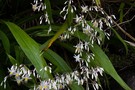
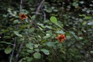
Rock lily
Photograph
•
Distance: 7.9km away
Rengarenga (Arthropodium cirratum) is common on rock faces in the North Island and Marlborough. It is also a popular garden ...
More ▶︎
Kelly's Stream
Photograph
•
Distance: 8.0km away
This stream is diverted over the top of the Waitakere Tramline.
More ▶︎
Turepo
Photograph
•
Distance: 8.1km away
Rhabdothamnus solandri, an odd shrub of the North Island. This one was on the West Tunnel Mouth Track, Waitakere Ranges.
More ▶︎
Waitakere Reservoir from Tramline Track
Photograph
•
Distance: 8.2km away
The Waitakere Reservoir from Tramline Track, this is a good option when doing the Montana Trail to skip the last ...
More ▶︎
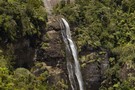
Waitakere Waterfall
Photograph
•
Distance: 8.2km away
Waitakere Waterfall used to be a big attraction in this part of the ranges, but rarely flows like this since ...
More ▶︎
Ōngāruanuku Hut
Hut
•
Club hut (Auckland University Tramping Club). Capacity: 12.Bookings required.
•
Distance: 8.4km away
Ōngāruanuku or "O'nuku" as it's known is maintained by the Auckland University Tramping Club. It was once an abandoned timber ...
More ▶︎
Craw Campground
Campsite
•
Backcountry Campsite (Private). 40 spaces.
•
Distance: 8.5km away
A new campsite built for the Hillary Trail. Located on the old Craw Homestead site on Anawhata Road.
More ▶︎
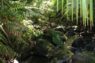
Peripatus Track, Waitakere
Photograph
•
Distance: 8.7km away
A beaut stream. Wonder if there are any peripatus around here anymore...
More ▶︎
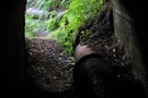
A pipe, a pipe!
Photograph
•
Distance: 8.7km away
An actual pipe on the Swanson Pipeline track, and a Filter Station on the filter track - it's all too ...
More ▶︎
Filter Track
Track
•
Easy/medium. One way.
•
Distance: 8.8km away
Short walk in the Waitakere Ranges.
More ▶︎
North Piha
GPX file
•
Distance: 8.9km away
Four tracks form a circuit at North Piha, and visit secluded Whites Beach.
More ▶︎
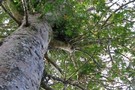
Kauri giant on the Filter Track
Photograph
•
Distance: 8.9km away
A beautiful ridge of kauri on this quiet track
More ▶︎
Fairy Falls Loop
GPX file
•
Distance: 9.9km away
Circuit in the Waitakere Ranges visiting the Fairy Falls and returning along the Old Coach Road.
More ▶︎
Marawhara Walk
Track
•
Easy. One way.
•
Distance: 10.0km away
Short walk to a North Piha picnic area.
More ▶︎