Nearby
Hakatere Conservation Park
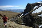
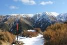
Mount Somers Summit Track
Track
•
1 day. Easy/medium. Return by the same track.
•
Distance: less than 100m away
The quicker, steeper route to the summit, from Sharplin Falls.
More ▶︎
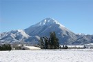
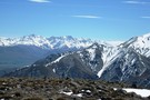
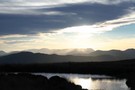
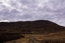
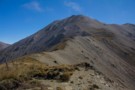
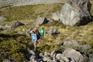
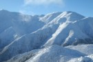
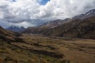
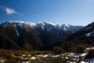
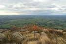
Mt Somers
Photograph
•
Distance: less than 100m away
This high foothill,1688m,gives great panoramas of the Canterbury Plains and views of Mts Cook,Winterslow,Hutt,Taylor,D`Archiac,Peel,Tripp,and more.About seven hours return.This view taken ...
More ▶︎
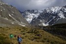
Mount Somers summit (from Woolshed Creek)
Track
•
2 days. Easy/medium. Return by the same track.
•
Distance: less than 100m away
A gentle climb over untracked tussock land to this easy summit.
More ▶︎
Te Kiekie route - Mt Somers
Track
•
Medium/hard. Loop track.
•
Distance: less than 100m away
New marked route linking the summit of Mt Somers with the Mt Somers track.
More ▶︎
An Unexpected Ascent of Mt Taylor
Article
•
Distance: less than 100m away
A day trip to climb the highest peak in the Canterbury foothills.
More ▶︎
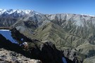
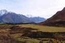
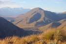
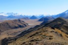
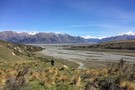
Arrowsmith Range
Photograph
•
Distance: 144m away
Arrowsmith range taken from Mt Somers. Lake Heron also visible. taken October 2006.
More ▶︎
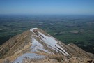
Mount Somers summit
Photograph
•
Distance: 220m away
This the main rout to the summit: the ridge leading down to Staveley Hill.
More ▶︎
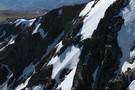
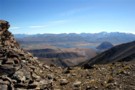
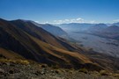
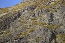
Geological contrasts
Photograph
•
Distance: 891m away
The ragged rhyolite cliffs of Mount Somers in the foreground, and the smoother Torlesse greywacke of the Winterslow Range beyond. ...
More ▶︎
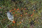
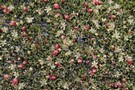
Coprosma perpusilla
Photograph
•
Distance: 1.1km away
Bog at the head of Trifalls Stream, Mount Somers summit.
More ▶︎
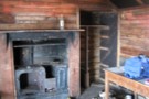
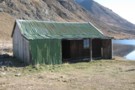
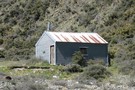
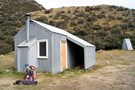
Pinnacles hut
Photograph
•
Distance: 1.2km away
Pinnacles hut, Mt Somers. taken October 2006
More ▶︎
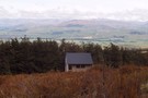
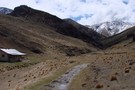
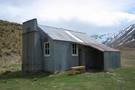
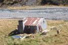
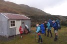
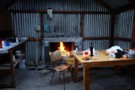
Pinnacles Hut (Hakatere)
Hut
•
Serviced Hut (DOC). Capacity: 19.
•
Distance: 1.2km away
A well-situated hut on the Mount Somers Track. The columnar basalt cliffs of Mount Somers provide a handsome backdrop. Limited ...
More ▶︎
Staveley Hill
Track
•
Easy. Return via same track.
•
Distance: 1.3km away
Part of the Mt Somers circuit, Staveley Hill climbs from Sharplin Falls carpark and past Hookey Knob along the south ...
More ▶︎
Mount Somers summit
Photograph
•
Distance: 1.4km away
Head of Trifalls Stream, looking west.
More ▶︎
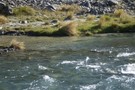
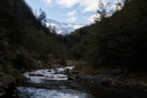
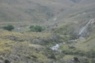
Trifalls Stream, near the summit
Photograph
•
Distance: 1.6km away
From a boggy flat near the Mount Somers summit, Trifalls Stream sets off under a rock field and drops into ...
More ▶︎
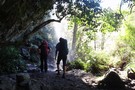
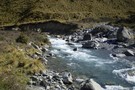
Mt Somers waterfall
Photograph
•
Distance: 1.6km away
A bit over half way into Pinnacles Hut,the track goes behind this pretty little falls;shady & cool on a summers ...
More ▶︎
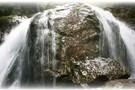
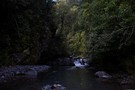
Sharplin falls
Photograph
•
Distance: 2.4km away
At the end of the walk to sharplin falls you'll find this.
More ▶︎
Sharplin falls
Track
•
Easy/medium.
•
Distance: 2.4km away
Walk along a stream to the Sharplin Falls.
Different walks are possible.
More ▶︎
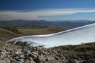
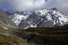
Evening, Mount Somers tarns
Photograph
•
Distance: 2.8km away
Camping on the gentle tussock slopes at around 1270m.
More ▶︎
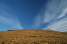
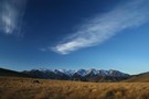
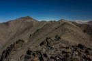
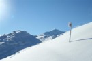
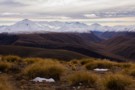
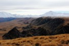
Gentle summit
Photograph
•
Distance: 2.8km away
The easy tussock slopes of the Mount Somers summit.
More ▶︎
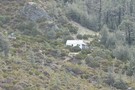
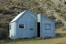
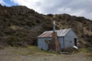
Woolshed hut
Photograph
•
Distance: 3.2km away
One of two huts on the mount somers walkway and is more like a hotel than a hut.
More ▶︎
Mount Somers Track
Track
•
2 days. Easy/medium. One way.
•
Distance: 3.2km away
Leading around the back of Mount Somers, an ancient volcano, this track explores a fascinating landscape with handsome grasslands and ...
More ▶︎
Mt Somers Track (South Face)
Track
•
1 day. Easy/medium. Return by the same track.
•
Distance: 3.2km away
Woolshed Creek Hut - Rhyolite Ridge Track junction (4 km) Time: 2 hr. The route takes in dynamic scenery with ...
More ▶︎
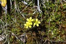
Ranunculus enysii
Photograph
•
Distance: 3.2km away
Growing in damp patches amongst tussocks on the slopes of Mount Somers.
More ▶︎
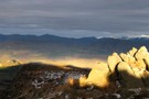
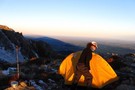
MtSomers sunrise
Photograph
•
Distance: 3.3km away
a couple of years ago,we camped at 1200m above the South Face of Mt Somers.Stunning light evening & morning,before we ...
More ▶︎
Lake Emma to Lake Camp
Track
•
Easy. Loop track with a road section.
•
Distance: 3.5km away
Easy day walk across flat country, visiting an historic hut.
More ▶︎
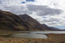
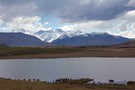
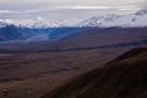
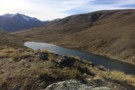
Lake Emma
Photograph
•
Distance: 4.1km away
Mount Potts (2194m) and Mount Guy beyond (1322m).
More ▶︎
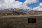
Top Hut (Te Kahui Kaupeka)
Photograph
•
Distance: 4.3km away
Top hut in the South Branch of the Ashburton River. taken 24-Oct-2011.
More ▶︎
Top Hut (Te Kahui Kaupeka)
Hut
•
Basic Hut/Bivvy (DOC). Capacity: 10.
•
Distance: 4.3km away
Top hut in the upper South Branch of the Ashburton River.
10 bunk hut built 1958 by Mt Arrowsmith Station. Taken ...
More ▶︎
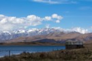
Lake Emma Hut
Photograph
•
Distance: 4.4km away
Lake Emma Hut with the Clent Hills and Mount Taylor (2330m) beyond.
More ▶︎
Miners Track to Woolshed Creek Hut
Track
•
Easy. Return via same track.
•
Distance: 4.5km away
This track follows, in part, the line the miners took to the old Blackburn Mine. The track, if accessed via ...
More ▶︎
Lake Emma hut
Hut
•
Shelter (DOC).
•
Distance: 4.5km away
An historic corrugated iron hut on the shoreline of Lake Emma. The hut is thought to date from the 1880s, ...
More ▶︎
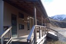
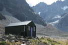
Woolshed Creek Hut
Hut
•
Serviced Hut (DOC). Capacity: 26.
•
Distance: 4.5km away
A new hut situated in a handsome tussock landscape on the Mount Somers Track. Ample camping nearby.
More ▶︎
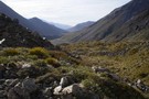
Woolshed Creek Hut surrounds
Photograph
•
Distance: 4.7km away
The steeply gorged rhyolite landscape around the new hut, with Woolshed Creek at left, Morgan Stream at right, and the ...
More ▶︎
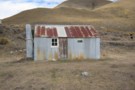
Ashburton Hut?
Photograph
•
Distance: 4.8km away
Ashburton hut(?) on the other side of the flooded South Branch of the Ashburton River. photo taken 26-Oct-2011.
More ▶︎
Ashburton Hut?
Hut
•
Basic Hut/Bivvy (PVT).
•
Distance: 4.8km away
Not sure if this really is called Ashburton hut, or what state it is in. I could see it on ...
More ▶︎
Wild Man Hut
Hut
•
Private hut (PVT). Capacity: 4.
•
Distance: 4.8km away
Musterer's hut owned by Mt Arrowsmith Station. Used by hunters but the odd tramper stays as well. Doesn't seem to ...
More ▶︎
Potts Hut
Hut
•
Basic Hut/Bivvy (DOC). Capacity: 10.
•
Distance: 4.8km away
Refurbished Musterers Hut in Hakatere Conservation Park.
More ▶︎
Double Hut
Hut
•
Basic Hut/Bivvy (DOC). Capacity: 6.
•
Distance: 4.9km away
A very basic retired mustering hut on the Swin River South Branch, near Lake Heron, and popular with hunters. The ...
More ▶︎
Lake Emma and hut
Photograph
•
Distance: 4.9km away
Tucked into the flanks of Mount Harper, Lake Emma Hut sits on the shore of the lake. The historic farm ...
More ▶︎
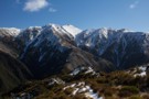
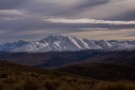
Steepface Hill Summit
Photograph
•
Distance: 5.3km away
Looking south toward Mount Hutt (2185m).
More ▶︎
Steepface Hill
Track
•
1 day. Medium. Return by the same track.
•
Distance: 5.3km away
A vigorous climb to a summit on the Mount Hutt Range. Spectacular views across the Rakaia River, Lake Coleridge, and ...
More ▶︎

Te Araroa Trail
Track
•
95 days. Medium. One way.
•
Distance: 5.5km away
Te Araroa is a walking trail running the entire length of the North and South Islands. The trail opened 3 ...
More ▶︎
Mount Guy
Track
•
1 day. Medium. Loop track.
•
Distance: 5.5km away
This loop takes in a little mountain and expansive views over Lake Clearwater and the Hakatere Basin.
More ▶︎
Lake Clearwater village to Mount Guy turn off
Section
•
Distance: 5.5km away
Follow the Lake Clearwater Circuit Track on a 4WD road by the eastern margin of the lake.
More ▶︎
Lake Clearwater Reserve
Campsite
•
Basic Campsite (Not applicable).
•
Distance: 5.5km away
Campsite and day use area on the banks of Lake Clearwater. There are a number of interesting walks in the ...
More ▶︎
Muehlenbeckia axillaris
Photograph
•
Distance: 5.6km away
This species is widespread around the Blackburn Mine site, Mount Somers.
More ▶︎
Mount Guy
Photograph
•
Distance: 5.6km away
This small hill at the foot of Lake Clearwater offers grand views of the mountains to the north and west.
More ▶︎
Double Crossing of the Wild Man Brothers Range
Article
•
Distance: 5.7km away
A 3 day trip going from the head of the Cameron River in the Hakatere over the above range to ...
More ▶︎
Tribulation Hut
Hut
•
Basic Hut/Bivvy (DOC). Capacity: 6.
•
Distance: 5.7km away
very basic 6 bunker on true left of the Swift River(Nth Ashburton River catchment).Just taken over by DOC through tenure ...
More ▶︎
DOC-revamped Tribulation Hut
Photograph
•
Distance: 5.7km away
A 6 bunker,no fire,4 hrs from Double Hill Road t/r Rakaia River,at Redcliffe Stream.
More ▶︎
Redcliffe Stream
Track
•
1 – 2 days. Easy/medium. Return by the same track.
•
Distance: 5.7km away
Short walk to an old musterers' hut near the Hutt Range.
More ▶︎
Manuka Hut
Hut
•
Basic Hut/Bivvy (DOC). Capacity: 6.
•
Distance: 6.1km away
A very basic hut near Lake Heron that is popular with Hunters. It is located 5 km away from Double ...
More ▶︎
Manuka Hut
Photograph
•
Distance: 6.1km away
Simple musterers' hut on the Stour River at the foot of the Mount Somers Range.
More ▶︎
Manuka Hut via Lake Emily
Track
•
Easy. Return by the same track.
•
Distance: 6.1km away
A short walk to a hut at the foot of the Mount Somers Range.
More ▶︎
Circuit of Branches of the Stour via Manuka Hut
Article
•
Distance: 6.1km away
Attractive alternative circuit via varied terrain.
More ▶︎
Manuka Range
Photograph
•
Distance: 6.4km away
On top looking towards Mt Sugarloaf and Mt Catherine with Ricki Spur (left ) and Longman Range ( right )
More ▶︎
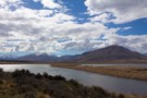
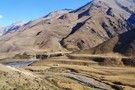
Rakaia Valley
Photograph
•
Distance: 6.5km away
Afternoon sun on Steepface Hill, beneath point 1488.
More ▶︎
Pudding Hill Stream Route
Photograph
•
Distance: 6.6km away
Setting off from Scott's Saddle, poles lead down 400 metres to the stream below. Point 1751 is across the valley.
More ▶︎
Scott's Saddle
Photograph
•
Distance: 6.6km away
Top of the Scott's Saddle Track on Mount Hutt, looking toward the Pudding Hill Range.
More ▶︎
Pudding Hill Stream Route
Track
•
1 day. Medium. One way.
•
Distance: 6.6km away
Unmarked route along Pudding Hill Stream in Mount Hutt Forest. Combine this route with the Scotts Saddle Track for an ...
More ▶︎
Scotts Saddle Track
Track
•
Easy/medium. Return by the same track.
•
Distance: 6.8km away
A short climb from the Awa Awa Rata Reserve to Scotts Saddle on the Mt Hutt Skifield road.
More ▶︎
Cookies Hut
Hut
•
Standard Hut (DOC). Capacity: 6.
•
Distance: 6.9km away
Former musterers' hut oft used by hunters. Now owned and newly renovated by DoC as of Feb 2016.
More ▶︎
Comyns Cookies travels
Photograph
•
Distance: 7.0km away
Various routes around these huts and A-Frame hut.
More ▶︎
Wild Mans Brother circuit
Photograph
•
Distance: 7.0km away
A weekend circuit in former pastoral lease country from the Cameron to the head of the South Ashburton River via ...
More ▶︎
Departing Cameron Hut
Photograph
•
Distance: 7.1km away
Time to leave the head of the valley before the weather closes in.
More ▶︎
Cameron River
Photograph
•
Distance: 7.1km away
Ahead lies a climb to avoid the river gorge.
More ▶︎
View from Cameron Hut
Photograph
•
Distance: 7.1km away
The area around Cameron Hut looks like an abandoned quarry the way the glaciers have moved and formed moraine.
More ▶︎
Big Stone
Photograph
•
Distance: 7.1km away
The scale of the surroundings can be hard to judge.
More ▶︎
Resting Place
Photograph
•
Distance: 7.1km away
Taking a break on the way up Cameron valley.
More ▶︎
Trout
Photograph
•
Distance: 7.1km away
Rumour has it that there are some good size trout in the river.
More ▶︎
Tahr
Photograph
•
Distance: 7.1km away
There is rumoured to be Tahr in these mountains!
(They can be very difficult to spot)
More ▶︎
Down Cameron Valley.
Photograph
•
Distance: 7.1km away
Looking down the Cameron Valley from the true right. This was taken not far from the Cameron Hut, which gave ...
More ▶︎
The Arrowsmith Range
Photograph
•
Distance: 7.1km away
Looking up the Cameron valley at the Arrowsmith Range, The Twins are to the peaks to the right.
More ▶︎
Beginning of Cameron valley and the Cameron River.
Photograph
•
Distance: 7.1km away
The Cameron river is located in the Wild Mans Brothers Range. At the top of the valley is the Arrowsmith ...
More ▶︎
cameron hut
Photograph
•
Distance: 7.1km away
the peaks above the flats between the moraine walls at the head of the Cameron river, including the Cameron Hut. ...
More ▶︎
Cameron river view
Photograph
•
Distance: 7.1km away
The main peaks of the Arrowsmith range, as seen from the middle Cameron valley, 2hrs from the road.
More ▶︎
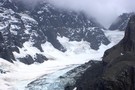
Cameron Glacier
Photograph
•
Distance: 7.1km away
Can be viewed an hour or two up behind the Cameron hut.
More ▶︎
D'Archiac and the Havelock River
Photograph
•
Distance: 7.2km away
Mount D'Archiac (2875m) is 43km away. It lies at the end of the Sibbald Range, just south of the Main ...
More ▶︎
Wild Mans Brother Range Circuit II
Article
•
Distance: 7.3km away
A longer circuit of the range with a stay in a refurbished musterers' hut in the head of the South ...
More ▶︎
Mount Somers looking north
Photograph
•
Distance: 7.4km away
The south face is steep and eroded. From the west, a gentle plain rises to the summit.
More ▶︎
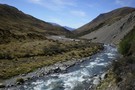
Stour River
Photograph
•
Distance: 7.6km away
Looking north, Manuka Hut is just around the hook in the river at the end of the Manuka Range.
More ▶︎
Labour Weekend Traverse of Black Hill Range
Article
•
Distance: 7.7km away
3 day weekend traverse of retired pastoral lease in the upper Rakaia on the former Black Hill and Redcliffe runs. ...
More ▶︎
Snoopys head on Manuka range
Photograph
•
Distance: 7.8km away
To get to this rock you clime up behind the Manuka hut and it's an easy walk along the top ...
More ▶︎
View from Mount Guy
Photograph
•
Distance: 7.9km away
To the left is point 2098 on the Big Hill Range, and the plateau of the Dogs Range.
To the ...
More ▶︎
Mount Potts
Photograph
•
Distance: 7.9km away
Mount Potts (2184m) with the Potts River in the foreground. Viewed from Mount Guy.
More ▶︎
Pudding Hill Range
Photograph
•
Distance: 7.9km away
Looking up to point 1603, from Scott's Track. August 2014.
More ▶︎

Cameron upper valley
Photograph
•
Distance: 8.1km away
The upper Cameron valley showing the Cameron glacier and Arrowsmith range. taken March 2008.
More ▶︎
Moraines below the Dogs Range
Photograph
•
Distance: 8.3km away
Moraines on the glacial till plain that drops from the plateau of the Dogs Range at right. Mystery Lake is ...
More ▶︎
Stone fireplace
Photograph
•
Distance: 8.7km away
Tucked away at the back of some river flats on Pudding Hill Stream.
More ▶︎
Lake Emily
Photograph
•
Distance: 8.8km away
Cameron Valley and the Arrowsmith Range beyond.
More ▶︎
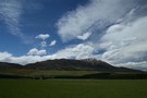
Mt Alford
Track
•
0 – 1 day. Easy/medium. Return by the same track.
•
Distance: 8.9km away
A walk through beech forest, open farmland and alpine scrub with great views of Mt Somers, Mt Winterslow and Mt ...
More ▶︎
Manuka Range/West Stour area
Photograph
•
Distance: 9.1km away
Manuka Hut is found at the far end of this low range.If you`re keen on MTB riding,old farm tracks will ...
More ▶︎
Manuka Range/Stour R. Circuit
Track
•
2 – 3 days. Easy/medium. Loop track with a road section.
•
Distance: 9.1km away
2 day circuit extended to 3 days by going into Woolshed Creek via Burma Rd then traversing Manuka Range
More ▶︎
Alder Track / Ridge Track / Scotts Saddle Track circuit
Track
•
Easy/medium. Loop track.
•
Distance: 9.3km away
A loop track in forest at the foot of Mount Hutt. Several variations are available.
More ▶︎
Lake Emily and the Mount Somers Range
Photograph
•
Distance: 9.3km away
Mount Taylor (2333m) is the summit of the range.
More ▶︎
Kowhai Flat
Campsite
•
Informal campsite (DOC).
•
Distance: 9.4km away
A basic campsite on the banks of the Rakaia River. This campsite is commonly used for fishing trips, but is ...
More ▶︎
Comyns Hut
Hut
•
Basic Hut/Bivvy (DOC). Capacity: 8.
•
Distance: 9.6km away
Corrugated iron hut on grassland next to Turtons Stream, south of Lake Coleridge. Constructed in 1957, restored in 2008, and ...
More ▶︎
Mystery Lake Track
Track
•
1 – 2 days. Easy. Loop track.
•
Distance: 9.6km away
Circuit track to a small tarn in the Ashburton Lakes.
More ▶︎
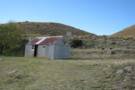
Boundary Creek Hut
Photograph
•
Distance: 9.8km away
A great little musterers hut in the Hakatere Conservation Park near the South Branch Asburton River.
More ▶︎
boundary creek hut
Photograph
•
Distance: 9.8km away
boundary creek hut in the distance walking up from the gorge
More ▶︎
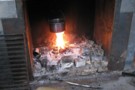
boundary creek hut
Photograph
•
Distance: 9.8km away
everyone likes a hot wash in the morning and with river water so close and a fire and billy why ...
More ▶︎
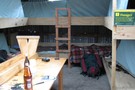
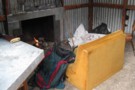
Boundary Creek Hut (Hakatere)
Hut
•
Basic Hut/Bivvy (DOC). Capacity: 8.
•
Distance: 9.8km away
boundary creek hut has 8 bunks and a concrete floor, mattresses and open fire and its very own resident mice ...
More ▶︎
Cameron Hut (Rangitata/Rakaia)
Hut
•
Basic Hut/Bivvy (DOC). Capacity: 9.
•
Distance: 9.9km away
Located close to Arrowsmith Range at the head of the Cameron River valley. This is a Canterbury Mountaineering Club Hut, ...
More ▶︎