Nearby
Richmond Ranges (east)
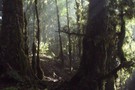
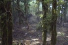
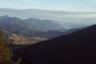
Ridgeline travel in the eastern Richmond Ranges
Photograph
•
Distance: less than 100m away
Ridgeline travel in the eastern Richmond Ranges
More ▶︎
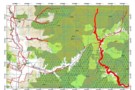
Route Guide: Richmond Ranges (east)
Article
•
Distance: less than 100m away
Tramping in the eastern Richmond Ranges between Picton and Okaramio (SH6)
More ▶︎
Picton to Aspiring
GPX file
•
Distance: 2.5km away
An aborted alpine traverse. Picton to West Cape, but aborted at Aspiring due to real world emergencies back home. Posted ...
More ▶︎
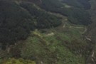
Cullen Creek Hut, Eastern Richmond Ranges
Photograph
•
Distance: 2.7km away
The Cullen Creek valley and Cullen Creek Hut on the Waikakaho - Cullen Creek Track in the Eastern Richmond Ranges. ...
More ▶︎
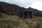
Cullen Creek Hut
Photograph
•
Distance: 2.7km away
Cullen Creek Hut on the Waikakaho - Cullen Creek Track, Eastern Richmond Ranges. Note, this is a locked, private hut.
More ▶︎
Cullen Creek Hut
Hut
•
Private hut (Private). Capacity: 4.Bookings required.
•
Distance: 2.7km away
This private 4-bunk hut is the only hut in the eastern Richmond Ranges. Sadly it is locked.
Camping spots exist ...
More ▶︎
Dukeshead, Richmond Ranges
Photograph
•
Distance: 3.2km away
Dukeshead: ridgeline travel in the eastern Richmond Ranges
More ▶︎
Havelock, from pt1045
Photograph
•
Distance: 3.7km away
Havelock, from pt1045 in the eastern Richmond Ranges
More ▶︎
Walking the length of the Richmond Ranges
Track
•
7 – 14 days. Medium/hard. One way.
•
Distance: 8.1km away
A 7-14 day walk along the spine of the Richmond Ranges. Alpine tops, crumbling ridgelines, untracked bush & scrub, boulders ...
More ▶︎
Legal access points from Kenningtons Road to the Richmond Ranges
Photograph
•
Distance: 8.6km away
Legal access points from Kenningtons Road to the Richmond Ranges - note that these access points are along paper roads ...
More ▶︎