Nearby
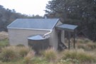
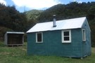
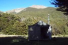
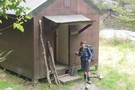
Starveall Hut
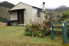
Starveall Hut
Photograph
•
Distance: less than 100m away
This hut is in a top spot and has an Awesome View.
More ▶︎
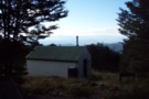
Starveall Hut
Photograph
•
Distance: 1.2km away
Nicely situated hut overlooking Nelson and bay in the Richmond Forest Park.Nearby residents include a nosey woodhen who enjoys smelly ...
More ▶︎
Mt Richmond Alpine Route
Track
•
5 days. Medium. One way.
•
Distance: 1.3km away
Long route above the bushline in Mt Richmond Forest Park near Nelson.
More ▶︎
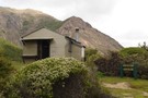
Starveall Hut (Richmond Ranges)
Photograph
•
Distance: 1.3km away
A tidy 6 bunk hut on the bushline in the Richmond Ranges.
Read my trip report on my blog http://waitakathlete.blogspot.co.nz/2017/07/solo-to-starveall.html
I couldn't ...
More ▶︎
Slaty Hut
Hut
•
Standard Hut (DOC). Capacity: 6.
•
Distance: 2.9km away
On the Mt Richmond Alpine Route.
More ▶︎
Whispering Falls walk/Hacket track
Track
•
0 – 1 day. Easy/medium. Return via same track.
•
Distance: 4.4km away
A gentle walk along the Hacket track to the beautiful Whispering Falls. Dogs permitted on leads.
More ▶︎
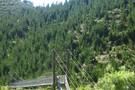
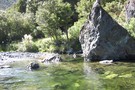
The Swing bridge
Photograph
•
Distance: 4.4km away
When hiking the Hacket, after about 20-30 mins from the Aniseed Valley car park, a swing bridge must be crossed. ...
More ▶︎
Hacket Circuit
Track
•
1 – 2 days. Easy/medium. Return via same track.
•
Distance: 4.4km away
A good day walk mainly along the Hacket Creek, including Hacket and Browning Huts. Dogs are allowed in the Mt ...
More ▶︎
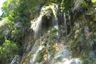
Whispering Falls
Photograph
•
Distance: 4.4km away
The "whisper" of the falls is created by the gentle trickling of the water
More ▶︎

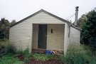
Hacket Hut
Photograph
•
Distance: 5.7km away
Another angle on this hut. Taken on New Year's Day 2005
More ▶︎
Hacket Hut
Hut
•
Standard Hut (DOC). Capacity: 6.
•
Distance: 5.7km away
This 6 bunk hut lies on the western edge of Mt Richmond Forest Park and is only 1½ hours walk ...
More ▶︎
Browning Hut
Hut
•
Standard Hut (DOC). Capacity: 8.
•
Distance: 6.2km away
Water from the nearby creek. Nice and bright inside due to skylights. Some wasps and mosquitoes seen and mice suspected. ...
More ▶︎
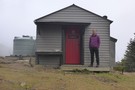
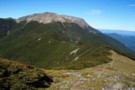
Mount Rintoul Hut
Photograph
•
Distance: 6.3km away
Mount Rintoul Hut in the Richmond Ranges with Nelson and the bay beyond.
More ▶︎
Mount Rintoul Hut
Hut
•
Standard Hut (DOC). Capacity: 6.
•
Distance: 6.3km away
Rintoul Hut / Mount Rintoul Hut (6 beds, matresses, stove, tank water) lies on the Alpine Route, 100m below the ...
More ▶︎
Picton to Aspiring
GPX file
•
Distance: 6.4km away
An aborted alpine traverse. Picton to West Cape, but aborted at Aspiring due to real world emergencies back home. Posted ...
More ▶︎
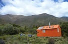
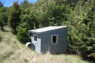
New Porters Creek Hut
Photograph
•
Distance: 6.4km away
moved to spot from right branch wairoa.
has beenlovingly restored with a new lick of 'rescue orange' paint and sports a ...
More ▶︎
Route Guide: Richmond Ranges (west) main ridge
Article
•
Distance: 6.4km away
The main ridge of the western Richmond Ranges from Mt Riley, near Okamario on SH6 to the Red Hills above ...
More ▶︎
Mount Rintoul summit
Photograph
•
Distance: 6.4km away
Mount Rintoul summit, Richmond Ranges
More ▶︎
Old Man Hut
Hut
•
Standard Hut (DOC). Capacity: 6.
•
Distance: 6.7km away
Old Man Hut (sleeps 6, wood-burning stove, firewood available, tank & stream water) sits in a large grassy clearing between ...
More ▶︎
Mt Rintoul from Old Man
Photograph
•
Distance: 6.7km away
Looking back towards Rintoul From Old Man. Old Man Hut lies 1km off ridge to the left of the saddle.
More ▶︎
Pelorus Track (via Rocks hut & Totara saddle)
Track
•
2 – 3 days. Easy/medium. One way.
•
Distance: 7.2km away
The Pelorus track is a semi-remote forest experience in Mount Richmond Forest park.It leads up the Pelorus valley and over ...
More ▶︎
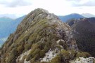
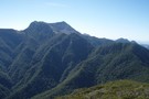
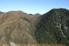
Richmond Range (pt 1424)
Photograph
•
Distance: 7.6km away
Richmond Range between Richmond Saddle and Ada Flats. A rough, but interesting route from Richmond Saddle Hut to Old Man ...
More ▶︎
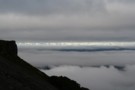
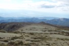
Kaikoura Ranges
Photograph
•
Distance: 7.8km away
View from Mt. Richmond, over the Marlborough region.
2 days before leaving, my last tramp in New Zealand...
More ▶︎
Walking the length of the Richmond Ranges
Track
•
7 – 14 days. Medium/hard. One way.
•
Distance: 8.8km away
A 7-14 day walk along the spine of the Richmond Ranges. Alpine tops, crumbling ridgelines, untracked bush & scrub, boulders ...
More ▶︎
Mount Malita Hut
Hut
•
Basic Hut/Bivvy (NA).
•
Distance: 9.9km away
Hut near the summit of Mount Malita (959m) on the edge of Mount Richmond Forest Park. Not listed as a ...
More ▶︎
Edge of Nelson Mineral Belt May 2014
Photograph
•
Distance: 10.0km away
This photo taken from Windy Point on the Dun Mountain Walk/Cycleway looks South West. It was taken to illustrate the ...
More ▶︎