Nearby
Youngman Stream Track
Youngman Stream Track
Track
•
1 day. Easy/medium. Return by the same track.
•
Distance: less than 100m away
Steady sidle up the Rakahuri / Ashley River from the Lees Valley to Youngman Stream Hut.
More ▶︎
Youngman (Puketeraki) Hut
Hut
•
Standard Hut (DOC). Capacity: 6.
•
Distance: less than 100m away
Classic 6 bunk NZFS hut with great working woodstove set in attractive clearing within beech forest at juction of Youngman ...
More ▶︎
Youngman Stream to Tarn Hut
GPX file
•
Distance: less than 100m away
Marked route between these huts.
More ▶︎
Youngman Stream Hut to Tarn Hut
Track
•
1 day. Medium. One way.
•
Distance: less than 100m away
Track connecting Youngman Stream and Tarn Huts in Puketeraki Conservation Area.
More ▶︎
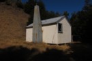
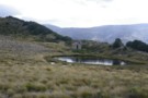
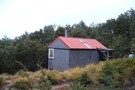
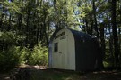
Youngman Stream Hut
Photograph
•
Distance: 143m away
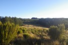
Looking south-west, showing new paint job on hut, taken July 2019.
More ▶︎
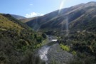
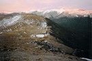
Upper Ashley River above Youngman Hut
Photograph
•
Distance: 665m away
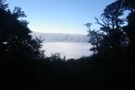
Upper Ashley River above Youngman Hut
More ▶︎
Lillburn Route
Track
•
1 day. Easy/medium. One way.
•
Distance: 930m away
Direct route up Lilburne Hill to Tarn Hut
More ▶︎
Tarn Hut, Lilburne Hill
Hut
•
Basic Hut/Bivvy (DOC). Capacity: 4.
•
Distance: 2.6km away
4 bed hut built in 1960s by Bruce Hassal of the NZFS (Simon Hassal's father) on a sheltered spot lee ...
More ▶︎
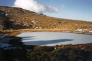
Tarn Hut
Photograph
•
Distance: 2.6km away
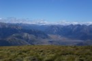
Tarn Hut & frozen tarn with Puketeraki Range in the background.
Taken from Lillburn Hill
More ▶︎
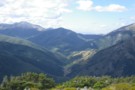
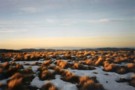
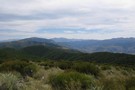
Lees Valley, Lillburn Range from Richardson
Photograph
•
Distance: 8.4km away
Lees Valley, Lillburn Range from Richardson
More ▶︎
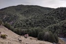
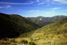
Clearings north of Mt Richardson
Photograph
•
Distance: 8.5km away
Clearings north of Mt Richardson - there's a bivvy here somewhere!
More ▶︎
Getting started
Photograph
•
Distance: 8.9km away
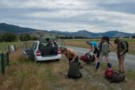
The traditional start: five trampers and packs crowd into a compact car then drive 1.5 hours. Townshend Track in the ...
More ▶︎
Black Hill
Track
•
2 days. Easy/medium. Return by the same track.
•
Distance: 9.0km away
A straightforward overnighter in the dry beech forests around Mount Oxford.
More ▶︎
Mt Richardson loop
Track
•
1 day. Easy. Loop track.
•
Distance: 9.2km away
Climb up steadily on a well-made track through tawhai forest and up to Mt Richardson (1047 metres). At the top ...
More ▶︎
Mount Richardson Track
Track
•
1 day. Easy/medium. One way.
•
Distance: 9.2km away
Forested climb from Glentui Bush car park to the summit of Mount Richardson (1047m).
More ▶︎
Mount Richardson Track
GPX file
•
Distance: 9.2km away
Climb from Glentui Bush Road up to the summit of Mount Richardson (1047m).
More ▶︎
Burnt forest, Mount Richardson
Photograph
•
Distance: 9.5km away
Looking northeast along Blowhard Stream.
More ▶︎
Okuku River - Pinchgut - Bob's Camp Bivvy - Mt Thomas
Track
•
1 – 2 days. Easy. One way.
•
Distance: 9.6km away
Nice overnighter with an easy to follow track. Possible to do in a long day if that's your thing.
More ▶︎
Blowhard Track
Track
•
Easy/medium. One way.
•
Distance: 9.7km away
Alternative route to the summit of Mount Richardson (1047m) in the Canterbury foothills.
More ▶︎
Bob's Camp Bivvy
Track
•
1 – 2 days. Easy/medium. Loop track.
•
Distance: 9.7km away
An easy day or overnight walk through beech forest and along easy ridges to a cute and comfortable biv.
More ▶︎
Bob's Camp Bivvy
Hut
•
Basic Hut/Bivvy (DOC). Capacity: 2.
•
Distance: 9.7km away
A cute and tidy biv with a curved corrugated iron roof. The biv is located in a small beech forest ...
More ▶︎
Mount Richardson Bypass Track
Track
•
1 day. Easy/medium. Return by the same track.
•
Distance: 9.9km away
This track drops from the ridge east of Mount Richardson to the Glentui Bush car park.
More ▶︎
Mount Richardson Bypass Track
GPX file
•
Distance: 9.9km away
This track pairs with the Mount Richardson Track to form a nice loop from Glentui Bush.
More ▶︎