Nearby
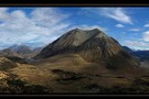
Mt Enys - Finally!
Lakes Ida and Catherine
Track
•
Easy. Return by the same track.
•
Distance: 6.1km away
A landscape of small glacial lakes near Lake Coleridge.
More ▶︎
Hog's Back Track
Track
•
Easy. Return by the same track.
•
Distance: 6.7km away
https://www.craigieburntrails.org.nz/tracks/hogs-back-track/
More ▶︎
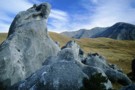
Striking limestone formations of Castle Hill
Photograph
•
Distance: 6.7km away
Known as Kura Tawhiti to Ngāi Tahu, this is an area of historic significance, with rock drawings hidden amongst the ...
More ▶︎
Hogs Back Circuit
Photograph
•
Distance: 7.1km away
A variation of the Hogsback mountain bike track. The mtb track is roughly marked as s-d-c-t. The walking circuit is ...
More ▶︎
Hogs Back Circuit
Track
•
Easy. Loop track.
•
Distance: 7.1km away
Great views of the Cass basin and surrounding mountain ranges.
More ▶︎
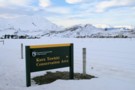
DOC sign
Photograph
•
Distance: 7.6km away
Kura Tawhiti Conservation Area is the karst landscape also known as Castle Hill, located on the road between Porter's and ...
More ▶︎
Korowai/Torlesse Tussocklands Park
Place
•
Conservation Park. 210.00km2.
•
Distance: 7.7km away
This park incorporates the Torlesse and Big Ben Ranges either side of Porter's Pass. The Torlesse Gap is a prominent ...
More ▶︎

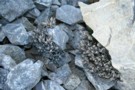
Patterned ground
Photograph
•
Distance: 7.8km away
Frost heave causes striping as the stones are sorted into smaller and larger. Ridge east of Red Hill.
More ▶︎
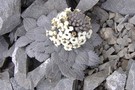
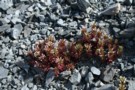
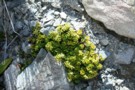
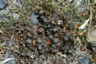
Coprosma atropurpurea
Photograph
•
Distance: 8.2km away
This Coprosma is very different from the native tree Coprosmas, but bears strikingly pretty, glassy berries. High in an alpine ...
More ▶︎
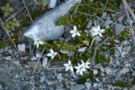
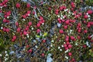
Gentiana montana
Photograph
•
Distance: 8.3km away
A particularly showy specimen, growing in a herbfield on Red Hill.
More ▶︎
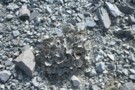
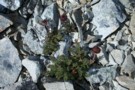
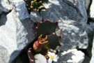
Scree buttercup (Ranunculus crithmifolius)
Photograph
•
Distance: 8.4km away
Located on scree just east of Red Hill.
More ▶︎
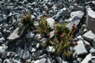
Epilobium pycnostachyum
Photograph
•
Distance: 8.4km away
Quite variable in colour from red to green, and scattered widely on scree at the saddle east of Red Hill.
More ▶︎
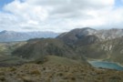
Red Hill
Photograph
•
Distance: 8.4km away
View towards Lake Coleridge from the Summit of Red Hill.
More ▶︎
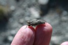
Leptinella atrata
Photograph
•
Distance: 8.4km away
A curious black flower on the summit of Red Hill.
More ▶︎
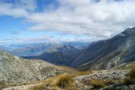
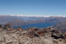
Red Hill from Trig M
Photograph
•
Distance: 8.4km away
Red Hill (1641m) is the highest peak to the right. The Lyndon Road winds past Lake Lyndon to Lake Coleridge ...
More ▶︎
Red Hill
Track
•
1 day. Medium. Loop track.
•
Distance: 8.4km away
A largely untracked route up Red Hill (1,641m), with magnificent views of Lake Coleridge, and the surrounding foothills. This loop ...
More ▶︎
Mount Ida
Photograph
•
Distance: 8.6km away
Mt. Ida is easily reached as a sidetrip to the Cass saddle/Lagoon saddle track near Arthur's pass. Just follow the ...
More ▶︎
Pratia macrodon
Photograph
•
Distance: 8.8km away
This creeper was found growing around rocks and at the edges of stony areas on Red Hill.
More ▶︎
Double Crossing of Craigieburn Range
Photograph
•
Distance: 8.9km away
Queens Birthday weekend trip, combined with scenic tour down the Harper to Mystery Tarn, on the Clay Range.
More ▶︎
Complete and Final Version of Craigieburn Double Crossing
Article
•
Distance: 8.9km away
Double crossing of the Craigieburn Range from Hogs Back MTB trail over to Hamilton Hut, then return via Mt Cheeseman ...
More ▶︎
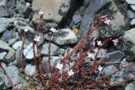
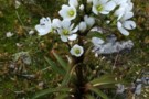
Geranium sessilifolium
Photograph
•
Distance: 9.0km away
Shingle river flats below Red Hill.
More ▶︎
Mt Plenty, Ghost Creek Circuit
Article
•
Distance: 9.0km away
A day trip involving a 700 m climb then descending a creek with 2 challenging sidles past waterfalls.
More ▶︎
Pentachondra pumila
Photograph
•
Distance: 9.2km away
These mats covered much of the ground on a low ridge near Red Hill.
More ▶︎
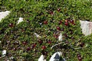
Lobelia roughii
Photograph
•
Distance: 9.6km away
This tiny plant was widespread on Red Hill scree slopes
More ▶︎
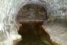
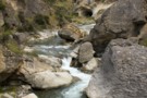
Cave Stream
Track
•
Medium. One way (about 5 mins walk from end to end).
•
Distance: 9.6km away
An exciting walk through a twisty limestone cave near Castle Hill.
More ▶︎
Mt Lyndon
Track
•
0 – 1 day. Easy/medium. Return by the same track.
•
Distance: 9.6km away
Day trip of moderate ascent of 650 m hill overlooking Lake Lyndon near Porters Pass. Route goes via low open ...
More ▶︎
Broken River Hut via Cave Stream
GPX file
•
Distance: 9.6km away
Alternative route to Broken River Hut. Land owners' permission needed.
More ▶︎