Nearby
Sleepy Hollow Pass route (Caples to Dart)

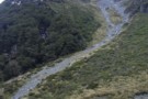
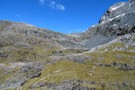
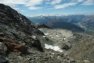
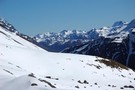
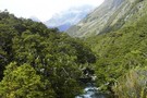
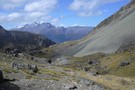
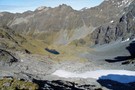
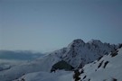
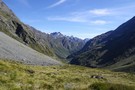
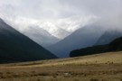
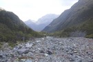
Descent to Glacier Burn
Photograph
•
Distance: less than 100m away
The final descent to Glacier Burn from pt1731, on the route from the Caples valley via Sleepy Hollow.
More ▶︎
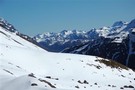
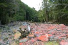
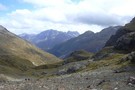
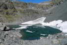
Glacier burn - ascent to sleepy hollow pass
Photograph
•
Distance: less than 100m away
From Glacier Burn to Sleepy Hollow pass: route leaves the Glacier Burn track and climbs this scree gully on the ...
More ▶︎
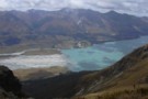
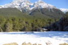
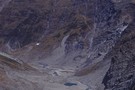
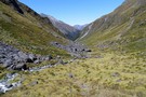
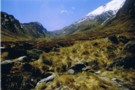
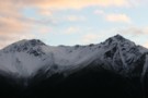
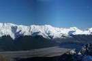
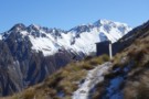
Sleepy Hollow
Photograph
•
Distance: less than 100m away
Sleepy Hollow from the top of the pass into the Dart.
More ▶︎
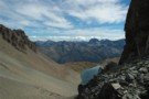
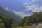
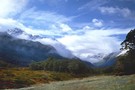
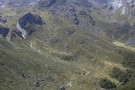
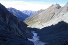
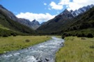
Gorge Creek / Dart Valley
Photograph
•
Distance: less than 100m away
Gorge Creek and the Dart Valley, from the Sleepy Hollow pass between the Caples and Dart valleys.
More ▶︎
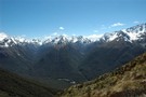
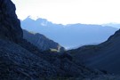
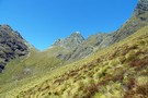
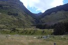
Sleepy Hollow
Photograph
•
Distance: less than 100m away
Sleepy Hollow above the mid Caples Valley. The pass to Gorge Creek / Glacier Burn and the Dart Valley is ...
More ▶︎
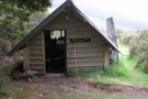
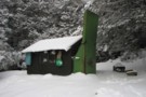
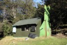
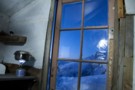
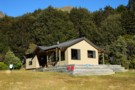
Mid Caples Hut
Hut
•
Serviced Hut (DOC). Capacity: 24.
•
Distance: less than 100m away
A new $535000 hut opened February 2014, to replace the smaller hut on the site.
The hut provides pleasant views over ...
More ▶︎
Scott Saddle route (Dart to Caples)
Track
•
1 – 2 days. Medium. One way.
•
Distance: 100m away
This route crosses the easiest pass from the Dart to Caples Valleys, via Scott Creek, Scott Saddle and Kay Creek ...
More ▶︎
Sleepy Hollow
Photograph
•
Distance: 118m away
situated on the ridge between Glenorchy and Caples Valley
More ▶︎
Sleepy Hollow
Photograph
•
Distance: 818m away
From near Bold Peak. Inspired by madpom, I went the opposite direction via Glacier Burn to Kay Creek
More ▶︎
Greenstone / Caples Tracks
Track
•
4 days. Easy/medium. Loop track.
•
Distance: 1.4km away
The Greenstone and Caples Tracks are often linked together to form a circuit from the shores of Lake Wakatipu. Long ...
More ▶︎
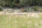
Caples Valley Fallow Deer
Photograph
•
Distance: 1.8km away
Spooked a mob of 30+ deer back in 06/07.
More ▶︎
Caples Track
Track
•
2 days. Easy/medium. One way.
•
Distance: 1.8km away
A quiet track climbing alongside the Caples River through forest and grassy flats and over a sub-alpine saddle.
More ▶︎
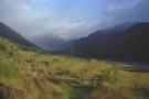
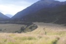
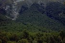
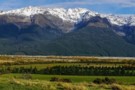
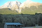
Mid Caples Valley
Photograph
•
Distance: 1.8km away
Mid Caples Valley from pt1168, just above the bushedge the way to Sleepy Hollow. Mid Caples Hut is just visible ...
More ▶︎
Home Hill Hut
Hut
•
Basic Hut/Bivvy (DOC). Capacity: 2.
•
Distance: 2.8km away
A rustic hut above the old Birchdale Homestead site in the Caples Valley.. Roof has been replaced and new bunks ...
More ▶︎
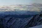
Key Summit
Photograph
•
Distance: 3.9km away
Key Summit from the Humboldts, looking towards the Earl Mountains. Kay Creek in the foreground
More ▶︎
Key Summit
Photograph
•
Distance: 3.9km away
Key Summit from the Humboldts, looking towards the Earl Mountains. Kay Creek in the foreground
More ▶︎
Paradise Road Glenorchy, New Zealand, Fiordland, April 2018
Photograph
•
Distance: 4.0km away
Paradise Road Glenorchy, New Zealand, Fiordland, April 2018
More ▶︎
Glenorchy Lagoon
Track
•
Easy. Loop track.
•
Distance: 4.5km away
Stroll along boardwalks through this lagoon occupying an old bend of the Rees River. The lagoon is dominated by willows, ...
More ▶︎
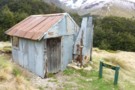
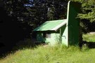
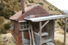
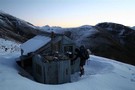
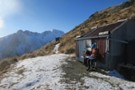
Kay Creek Hut
Photograph
•
Distance: 4.6km away
Kay Creek Hut, between the Caples and Dart valleys.
More ▶︎

Haast to The Divide
GPX file
•
Distance: 5.1km away
Andrew Barker's traverse 2009. From Pleasant Flat in the Haast to The Divide via Mt Aspiring National Park.
More ▶︎
Fraser Creek & Kay Creek
Photograph
•
Distance: 5.4km away
View from route to Steele Creek from the Upper Caples hut
More ▶︎
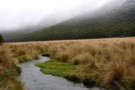
Kay Creek
Photograph
•
Distance: 5.5km away
Kay Creek, looking downstream from Kay Creek Hut
More ▶︎
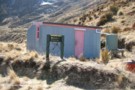
Kay Creek Hut
Hut
•
Basic Hut/Bivvy (DOC). Capacity: 3.
•
Distance: 5.5km away
Kay Creek Hut (sleeps 3-4, fireplace, firewood available, creek water) makes up for in character what it lacks in comfort. ...
More ▶︎
Kay Creek - Upper Caples
Photograph
•
Distance: 5.5km away
April 2006 - Taken while coming back down Kay Creek to the Upper Caples DOC hut
More ▶︎
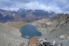
Dart Valley from Kay Saddle
Photograph
•
Distance: 5.6km away
Looking back down through Scott Basin to the Dart from Kay saddle
More ▶︎
Scott Saddle
Photograph
•
Distance: 5.8km away
Scott Saddle (1450m) between Scott Creek and Kay Creek. This is the easiest pass between the Dart and Caples valleys. ...
More ▶︎
Scott Saddle
Photograph
•
Distance: 5.8km away
Scott Saddle (1450m) between Scott Creek and Kay Creek. This is the easiest pass between the Dart and Caples valleys. ...
More ▶︎
steele creek track
Track
•
3 days. Medium. Loop track.
•
Distance: 5.9km away
Rugged route following steele creek. This track connets the Greenstone and caples valley bypassing the popular Mckellar hut but this ...
More ▶︎
Death Valley Saddle
Photograph
•
Distance: 5.9km away
Death Valley is an offshoot of Kay Creek and makes an interesting and straight forward alternative to a crossing from ...
More ▶︎
Not The Routeburn
GPX file
•
Distance: 6.1km away
A six-passes, seven catchments trip through the Humboldt Mountains from Glenorchy to The Divide.
Note that for access from Double Barrel ...
More ▶︎
Steele Creek Hut
Photograph
•
Distance: 6.1km away
Picture of the Renovated Steele Creek Hut.
More ▶︎
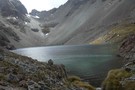
Kay Lake and Death Valley Saddle
Photograph
•
Distance: 6.2km away
Death Valley is an offshoot of Kay Creek and makes an interesting and straight forward alternative to a crossing from ...
More ▶︎
Death Valley from Saddle
Photograph
•
Distance: 6.3km away
Death Valley is an offshoot of Kay Creek and makes an interesting and straight forward alternative to a crossing from ...
More ▶︎
Fraser Creek
Track
•
1 – 2 days. Easy/medium. One way.
•
Distance: 6.3km away
One of several valleys that cut into the southern Humboldt Mountains. It passes through many kilometres of beech forest, river ...
More ▶︎
Greenstone Track
Track
•
2 – 3 days. Easy. One way.
•
Distance: 6.4km away
A famous, easy track along red tussock river flats.
More ▶︎
Heather Jock Hut
Track
•
1 – 2 days. Easy. Loop track.
•
Distance: 6.6km away
A gentle climb through a mining area to a small hut with panoramic mountain views.
More ▶︎
Death Valley
Photograph
•
Distance: 6.7km away
Death Valley is an offshoot of Kay Creek and makes an interesting and straight forward alternative to a crossing from ...
More ▶︎
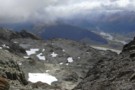
Scott Basin
Photograph
•
Distance: 7.0km away
Scott Basin at the head of Scott Creek, between the Dart and Caples valleys. Scott Creek Hut (dilapidated) is located ...
More ▶︎
steele creek hut
Hut
•
Basic Hut/Bivvy (DOC). Capacity: 3.
•
Distance: 7.1km away
old deer hunters hut. it has got a mud floor and sack bunkings and when i went there the hut ...
More ▶︎
Scott Creek Hut (removed)
Hut
•
Removed!
•
Distance: 7.2km away
Hut has been removed (2010?). Details below for old-time's sake ...
Scott Creek Hut (4 beds, fireplace, firewood available, creek water) ...
More ▶︎
Slip Flat Hut in the snow
Photograph
•
Distance: 7.2km away
Taken in August 2011 on a hunting trip
More ▶︎
Rees Vally
Photograph
•
Distance: 7.2km away
This is a picture taken on the rees/dart track and is on day 2 of our tramp in between shelter ...
More ▶︎
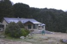
Upper Caples Hut
Hut
•
Club hut (Southern Lakes Deerstalkers Association). Capacity: 16.Bookings required.
•
Distance: 7.4km away
Comfortable hut in the Upper Caples Valley.
This hut was closed to the public in February 2014, but is now reopened ...
More ▶︎
Picnic area at Greenstone Station Road Car Park
Hut
•
Shelter (DOC).
•
Distance: 7.4km away
Picnic tables, barbecues.
More ▶︎
lake rere track
Track
•
Easy. Loop track.
•
Distance: 7.5km away
simple half day track aroundlake rere. this is a easy track but no wheel chair access. the lake is cool ...
More ▶︎
Slip Flat hut
Photograph
•
Distance: 7.8km away
Lovely old-style tramping hut, open fire, bunks, away from the madding crowds.
More ▶︎
Slip Flat hut
Hut
•
Basic Hut/Bivvy (DOC). Capacity: 3.
•
Distance: 7.8km away
Cute little hut tucked away on Slip Flat in the Greenstone Valley. It is a deer hunting hut but DOC ...
More ▶︎
Death Valley glacier (rems.)
Photograph
•
Distance: 7.8km away
Death of a glacier.
Death Valley, Humboldt Mountains
More ▶︎
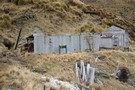
McIntyre Hut
Hut
•
Standard Hut (DOC). Capacity: 5.
•
Distance: 7.9km away
Corrugated iron miners' hut dating from the 1960s.
More ▶︎
Double Barrel Creek
Photograph
•
Distance: 8.1km away
Double Barrel Creek from the pass into Death Valley.
Catchment is blocked by twin falls at its lower end, but ...
More ▶︎
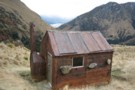
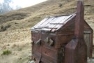
Jean Hut
Hut
•
Overnight use prohibited (DOC).
•
Distance: 8.7km away
Historic miners' hut clad in flattened iron drums. It features a series of rocks suspended from the roof to hold ...
More ▶︎
McIntosh hut
Photograph
•
Distance: 8.7km away
McIntosh hut. Mt Earnslaw in background. taken Sept 2015
More ▶︎
McIntosh Hut (Mac's Hut)
Hut
•
Basic Hut/Bivvy (DOC). Capacity: 4.
•
Distance: 8.7km away
Scheelite miners' hut high on Mount McIntosh, dated around 1915.
More ▶︎
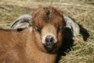
Goat kid
Photograph
•
Distance: 8.7km away
Near Jean Hut, Mount Alaska. This young goat was dozing comfortably in the sun, and quite confused about whether or ...
More ▶︎
lower Greenstone valley
Photograph
•
Distance: 8.7km away
looking south, near the confluence of Greenstone River and Steele Ck (April 2009)
More ▶︎
Fraser Creek flats
Photograph
•
Distance: 9.1km away
Fraser Creek passes through several grass flats which get more and more pleasant the closer to the head of the ...
More ▶︎
Boozer Hut
Hut
•
Basic Hut/Bivvy (DOC).
•
Distance: 9.1km away
An historic hut named for a notorious 1930s scheelite miner. The hut is clad in flattened steel drums, and contains ...
More ▶︎
mid-Greenstone valley
Photograph
•
Distance: 9.1km away
Looking south, a few km from McKellar hut (April 2009)
More ▶︎
Boyd Creek to The Divide via Kiwi Burn and the Mavora Walkway
Article
•
Distance: 9.1km away
A New Year's trip through the Snowdon Forest and on to The Divide. Heavily affected by weather, I had to ...
More ▶︎
Mid Greenstone Hut
Hut
•
Standard Hut (NZDA). Capacity: 16.Bookings required.
•
Distance: 9.2km away
This hut in the Greenstone Valley was managed by DOC, but has since been sold to the New Zealand Deerstalkers ...
More ▶︎
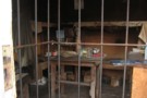
Bonnie Jean hut interior
Photograph
•
Distance: 9.2km away
Bonnie Jean hut interior. taken Sept 2015
More ▶︎
Bonnie Jean Hut
Hut
•
Overnight use prohibited (DOC).
•
Distance: 9.2km away
Built in 1943, this hut near Bonnie Jean Mine is preserved as an on-site museum. It features an old tractor ...
More ▶︎
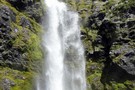
Fraser Creek Waterfall
Photograph
•
Distance: 9.2km away
Unnamed waterfall crashing out of a hanging valley about half way up the Fraser. Its well worth the 15-20 minute ...
More ▶︎
Whakaari Conservation Area
Place
•
Place. 94.00km2.
•
Distance: 9.3km away
Mountains east of Glenorchy, dotted with scheelite miners' huts and relics.
More ▶︎
Heather Jock Hut
Hut
•
Basic Hut/Bivvy (DOC). Capacity: 3.
•
Distance: 9.4km away
A small miner's hut high on Mount Alaska, near Glenorchy. This little-used hut combines easy access with spectacular panoramic views ...
More ▶︎
Morning view from Heather Jock Hut.
Photograph
•
Distance: 9.4km away
From left: Tooth Peak 2061m near the Greenstone River mounth, Mount Judah 1416m (foreground), Bold Peak 2118m and Mount Bonpland ...
More ▶︎
Dusk, near Heather Jock Hut
Photograph
•
Distance: 9.4km away
Looking northwest, toward the Cosmos Peaks and Mount Earnslaw.
More ▶︎
Heather Jock Hut
Photograph
•
Distance: 9.4km away
Wrestling with the sticky door, August 2008.
More ▶︎
Heather Jock Hut
Photograph
•
Distance: 9.4km away
August evening with Mount McIntosh in the background.
More ▶︎
Toilet at Heather Jock Hut
Photograph
•
Distance: 9.4km away
This long drop toilet forms part of a scenic view from Heather Jock Hut.
The axle and remains of a solid ...
More ▶︎
Heather Jock Hut
Photograph
•
Distance: 9.4km away
A spectacular location above Glenorchy where the old time Sheelite miners used to toil away. Reached via a track from ...
More ▶︎
Slyburn Hut (Defunct)
Hut
•
Standard Hut (DOC). Capacity: 8.
•
Distance: 9.8km away
This hut on the Greenstone Track has been superceded by the new Greenstone Hut on the same site. The Slyburn ...
More ▶︎
Snow on the Tops
Photograph
•
Distance: 9.8km away
A light snowfall on the tops near the Greenstone hut - April 2009
More ▶︎
Greenstone Hut
Hut
•
Serviced Hut (DOC). Capacity: 20.
•
Distance: 9.8km away
This hut is built on the site of the old Sly Burn Hut, and replaces the Mid Greenstone Hut. Sly ...
More ▶︎
Buckler Burn Forks Hut (Delapidated)
Hut
•
Derelict hut (DOC).
•
Distance: 9.9km away
This old miners' hut is located at the confluence of Wallers Creek with the Buckler Burn.
More ▶︎