Nearby
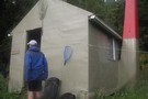
Nthn Brunner Range from Mt Curtis

Mt Curtis Hut June 2014
Photograph
•
Distance: 1.4km away
This photo shows a rear view of the new Mt Curtis Hut and gives a glimpse of the the tussock ...
More ▶︎
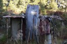
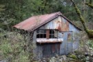
Old Mt Curtis Hut Brunner Range
Photograph
•
Distance: 1.5km away
This hut has been superceeded by a new Mt Curtis Hut built in 2012. The hut sites are about 90m ...
More ▶︎
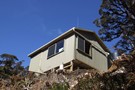
Mt Curtis Hut
Hut
•
Standard Hut (n/a). Capacity: 4.
•
Distance: 1.9km away
This newish hut completed 2012 is a replacement hut for the old Mt Curtis Hut. The new hut is the ...
More ▶︎
Lyell Campsite
Campsite
•
Standard Campsite (DOC). 18 spaces.
•
Distance: 5.9km away
This grassy camping space occupies a terrace above Lyell Creek, next to Kawatiri / the Buller River. The site was ...
More ▶︎
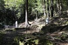
Pioneer Cemetery Walk
Track
•
Easy. Return via same track.
•
Distance: 6.0km away
A brief, easy walk to Lyell Cemetery, hidden under beech forest above the creek.
More ▶︎
Old Ghost Road
GPX file
•
Distance: 6.0km away
A GPS track of the Old Ghost Road November 2017
More ▶︎
Old Ghost Road
Track
•
4 – 5 days. Easy/medium. One way.
•
Distance: 6.2km away
This new trail links the ghost town of Lyell with the Mokihinui River. The first section is open from 2 ...
More ▶︎
Lyell Walkway
Track
•
Easy. Loop track.
•
Distance: 6.7km away
This loop track under pretty beech forest explores the history of the gold mining town of Lyell, including cemetery, stamper ...
More ▶︎
Derelict miners hut Lyell Creek May 2014
Photograph
•
Distance: 7.3km away
This photo shows a surviving historic miners hut near the confluence of Lyell Creek and Irishmans Creek. (It is on ...
More ▶︎
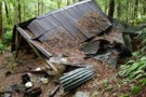
Remains of Eight Mile Hut Lyell Jan 2015
Photograph
•
Distance: 8.8km away
I popped in to this hut when returning from a visit to check out the new Stern Valley and Ghost ...
More ▶︎