Nearby
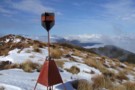
Mt Ruberslaw trig beacon etc Feb 2019
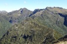
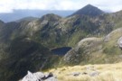
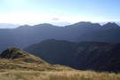
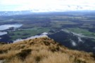
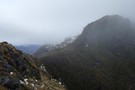
Heart of Hohonu Range from Mt Ruberslaw
Photograph
•
Distance: less than 100m away
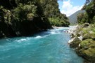
Taken Feb 2019 this photo looks WNW to the main Hohonu Range from beside the Ruberslaw trig.
Many of the peaks ...
More ▶︎
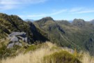
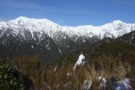
Taff Tor etc. Hohonu Range Feb 2019
Photograph
•
Distance: 1.6km away
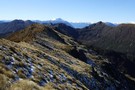
I took this photo when traversing southward down the Hohonu Range.
Taff Tor which is the second high point just left ...
More ▶︎
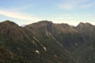
Three Hohonu Peaks
Photograph
•
Distance: 1.6km away
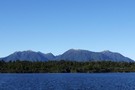
This picture was taken in March 2013 from the Hohonu Ridge tops east of Castle Hill. i.e. This photo is ...
More ▶︎
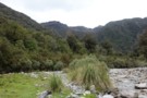
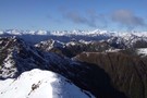
Eastern Hohonu River headwaters
Photograph
•
Distance: 1.6km away
This photo view is SE in to the heart of the Hohonu Range from about 4km up river of the ...
More ▶︎
Lake Ruby Hohonu Range
Photograph
•
Distance: 2.9km away
This photo taken while doing a tops traverse of part of the Hohonu Range shows seldom seen Lake Ruby. The ...
More ▶︎
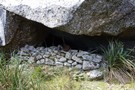
Historic Rock Bivvy, Hohonu Range
Photograph
•
Distance: 4.8km away
This snap shows a man made rock wall at the bivvy. I've displayed a few of the many relics found ...
More ▶︎
Smart Creek Rock Bivvy, Hohonu Range
Rock bivouac
•
Distance: 4.8km away
A large rock in the head basin of Smart Creek. An historic bivvy that has been used since the 1890's. ...
More ▶︎
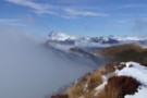
View SE from Mt French July 2011
Photograph
•
Distance: 4.8km away
This pic was taken from the summit of Mt French and looks across the Hohonu Ranges and the Taramakau valley ...
More ▶︎
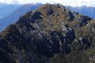
Mt Treacey Sept 2013
Photograph
•
Distance: 5.1km away
This picture of Mt Treacey in the Hohonu Range was taken from Mt Bruce Murray. You are looking at the ...
More ▶︎
Mt Alexander in Background
Photograph
•
Distance: 5.7km away
Taken from beside radio tower below summit of Mt French at point 1233
More ▶︎
Mt French
Track
•
1 day. Easy/medium. Return via same track.
•
Distance: 5.7km away
The track starts approximately 12 km east of Kumara on the Inchbonnie-Kumara Road, or 26 km from Moana following the ...
More ▶︎
Glimpse of Lake Brunner from Mt French July 2011
Photograph
•
Distance: 5.7km away
This photo was taken while climbing Mt French and looks down past point 1233m, where there is a radio repeater ...
More ▶︎
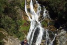
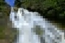
Carew Falls June 2011
Photograph
•
Distance: 6.1km away
We popped into have a look at the falls yesterday. For me it was the first visit for many years. ...
More ▶︎
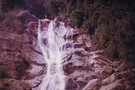
On top of Carew Falls mid 1970's
Photograph
•
Distance: 6.1km away
This pic is about 35 years old. Carew Falls have been a tourist attraction since the early 1900's. Presumably promotion ...
More ▶︎
Taipo River, near Jacksons
Photograph
•
Distance: 6.8km away
Rocky Creek meets the Taipo River at this point, and you will too if you miss the track markers. Safer ...
More ▶︎
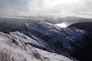
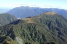
Hohonu Range tops August 2013
Photograph
•
Distance: 6.9km away
This photo was taken from the knob just SE of Mt Smart and looks eastward through part of the Hohonu ...
More ▶︎
Hohonu Range from Kapitea Reservoir
Photograph
•
Distance: 6.9km away
This photo was taken from the Westland Wilderness Trail (Cycle Trail) at the Kapitea Reservoir near Kumara and looks eastward ...
More ▶︎
Carew Falls
Track
•
Easy. Return via same track.
•
Distance: 7.0km away
A brief climb to the Carew Falls behind the Lake Brunner Lodge
More ▶︎
Griffin Creek
GPX file
•
Distance: 7.6km away
The route in to Griffin Creek Hut from the highway.
More ▶︎
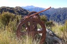
Relic from Griffin Range Serpentine Mine May 2010
Photograph
•
Distance: 7.7km away
This pic was taken at the old mine area where there are lots of relics. The perspective is looking NE ...
More ▶︎
Griffin Range
Track
•
1 – 3 days. Medium. Return via same track.
•
Distance: 7.7km away
A traverse of undulating tops to the summit of Mount Griffin. Good camping next to pretty tarns, striking cliffs, and ...
More ▶︎
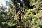
Negotiating treefall - Griffin Tops track
Photograph
•
Distance: 8.4km away
It's familiar, but climbing over on the return.
Took a way around on the ascent.
More ▶︎
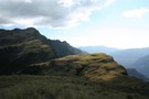
Te Kinga tops
Photograph
•
Distance: 8.5km away
This pic shows the trig near the track terminus and the view to the SE. This is not the highest ...
More ▶︎
Mt Te Kinga
Photograph
•
Distance: 8.5km away
This pic looking across Lake Brunner to Mt Te Kinga was taken from the spit at the mouth of the ...
More ▶︎
McInerney tops
Photograph
•
Distance: 8.6km away
This photo shows from Rocky Saddle through to the northern end of the McInerney tops with the Hohonu Range beyond ...
More ▶︎
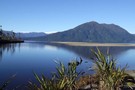
Mts Te Kinga & Alexander August 2011
Photograph
•
Distance: 8.8km away
This photo looks along the Te Kinga tops from the low peak near the trig to the top of Te ...
More ▶︎
Mount Te Kinga Lake Brunner
Track
•
Medium. Return via same track.
•
Distance: 8.8km away
To lookout;
Time: 3 hrs
Distance: 5.4 km return
To summit:
Time: 8 hrs
Distance: 12.4 km return
The track begins at the end ...
More ▶︎
Mount Te kinga
Photograph
•
Distance: 8.8km away
Looking down on Cashmere and Iveagh Bays from summit of Mt Te kinga
More ▶︎
Bain Bay
Track
•
Easy. Return via same track.
•
Distance: 9.1km away
Lakeside walk through swampy kahikatea groves and rich podocarp forest, Lake Brunner.
More ▶︎
Head of Griffin Creek July 2011
Photograph
•
Distance: 9.3km away
This pic was taken a few minutes along the Griffin Range route from the turnoff from the Harrington Creek - ...
More ▶︎
Griffin Creek - Rocky Creek
Track
•
2 – 3 days. Medium. Return by the same track.
•
Distance: 9.6km away
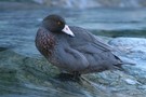
An isolated circuit west of Arthur's Pass along lightly used tracks and rocky riverbeds that are home to blue ducks.
More ▶︎
Rocky Creek Bivvy
Hut
•
Basic Hut/Bivvy (DOC). Capacity: 2.
•
Distance: 9.6km away
Located on a small forested flat on Rocky Creek, north of the Tara Tama Range. This hut is very easily ...
More ▶︎
Rocky Creek / Griffin Creek
Track
•
2 – 3 days. Medium. Loop track with a road section.
•
Distance: 9.6km away
2 day circuit in luxurious west coast bush with short above the bushline tussock section. 2 huts, Griffin Hut is ...
More ▶︎
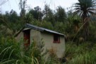
Rocky Creek Biv
Photograph
•
Distance: 9.6km away
A little hut situated on a discreet terrace.
More ▶︎
Mt Turiwhate track
Track
•
1 day. Medium. Return by the same track.
•
Distance: 9.9km away
A route from SH73 at Grahams Creek, Turiwhate up to the tussock tops from where you can continue to the ...
More ▶︎
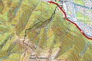
Mt Turiwhate track map
Photograph
•
Distance: 9.9km away
This map shows the gps'd route from SH73 up on to the tussock & rock main ridge leading to Mt ...
More ▶︎