Nearby
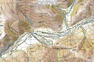
Peters Valley Track
Edwards River Track
GPX file
•
Distance: 867m away
Tophouse Road to Scotties Camp Hut, in the St James Conservation Area.
More ▶︎

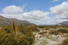
St James Conservation Area
Place
•
Place. 781.96km2.
•
Distance: 3.6km away
A large new recreational area featuring tussock grasslands, and including the headwaters of the Waiau and Clarence Rivers.
More ▶︎
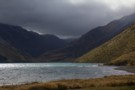
Edwards River, Lake Guyon, Fowler Pass circuit
Track
•
3 days. Easy/medium. Loop track with a road section.
•
Distance: 3.9km away
This circuit explores the southern portion of the St James Cycle Trail, explores the historic farm country around Lake Guyon ...
More ▶︎
Section: Edwards River - McArthur Track
Track
•
2 days. Easy/medium. One way.
•
Distance: 3.9km away
The southernmost section of the St James Cycle Trail, between Tophouse Road and the Lake Guyon junction on the Waiau ...
More ▶︎
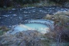
Cow Stream Hot Pool
Article
•
Distance: 6.4km away
A spacious, pleasant hot pool that can even be accessed by 4WD in the new St James Conservation Area.
More ▶︎
Location of Cow Stream Hot Pool
Photograph
•
Distance: 6.4km away
Just down the terrace from the isolated escarpment which can be accessed by 4WD.
More ▶︎
Molesworth Recreation Reserve
Place
•
Reserve. 1807.87km2.
•
Distance: 8.8km away
An iconic high country station located behind the Kaikoura Ranges.
More ▶︎
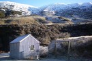
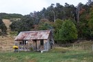
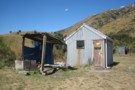
Scotties Hut - Edwards River Valley
Photograph
•
Distance: 9.2km away
Scotties Hut located in the Edwards River Valley on the 4WD track/St James Cycle Trail
More ▶︎
Scotties Camp Hut
Hut
•
Basic Hut/Bivvy (DOC). Capacity: 4.
•
Distance: 9.2km away
Former musterers' hut on St James Station down by the Edwards River. Now part of the DOC estate in the ...
More ▶︎
McArthur Track
GPX file
•
Distance: 9.2km away
Scotties Camp Hut to Pool Hut, St James Conservation Area.
More ▶︎
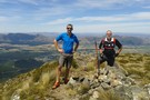
Mt Dumblane
Track
•
1 day. Easy/medium. Return by the same track.
•
Distance: 9.2km away
An alternative to the more popular Mt Isobel at Hanmer Springs, this track is an easy climb with a reward ...
More ▶︎