Nearby
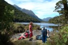
Cascade Creek Campsite
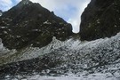
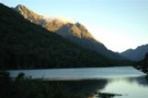
Lake Gunn to Falls Creek.
Track
•
1 – 2 days. Hard. One way.
•
Distance: 2.4km away
A challenging day trip or overnight trip in Fiordland.
More ▶︎
U Pass
Track
•
1 – 2 days. Medium. Loop track.
•
Distance: 3.1km away
A short loop track in the Earl Mountains.
More ▶︎
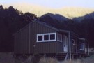
McKellar Hut
Hut
•
Serviced Hut (DOC). Capacity: 26.
•
Distance: 5.5km away
New hut is being built/opened November 2011. Capacity for 26, two separate bunkrooms and main room.
More ▶︎
Boyd Creek to The Divide via Kiwi Burn and the Mavora Walkway
Article
•
Distance: 6.0km away
A New Year's trip through the Snowdon Forest and on to The Divide. Heavily affected by weather, I had to ...
More ▶︎
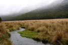
Greenstone Track
Track
•
2 – 3 days. Easy. One way.
•
Distance: 6.6km away
A famous, easy track along red tussock river flats.
More ▶︎
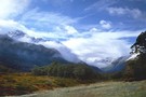
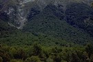
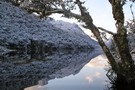
mid-Greenstone valley
Photograph
•
Distance: 6.6km away
Looking south, a few km from McKellar hut (April 2009)
More ▶︎
Mavora-Greenstone Walkway
Track
•
4 days. Easy. One way.
•
Distance: 6.9km away
Links with Greenstone Track.
More ▶︎
Greenstone / Caples Tracks
Track
•
4 days. Easy/medium. Loop track.
•
Distance: 6.9km away
The Greenstone and Caples Tracks are often linked together to form a circuit from the shores of Lake Wakatipu. Long ...
More ▶︎
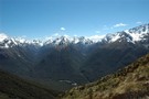
McKellar Saddle (945 m), Upper Caples Valley
Photograph
•
Distance: 7.8km away
After a steep climb up from Lake McKellar in the Upper Greenstone, you are treated to spectacular views of the ...
More ▶︎
Falls Creek
Track
•
1 – 2 days. Medium. Return by the same track.
•
Distance: 8.2km away
Day or overnight trip to a choice of two rock bivvies off the Milford Road.
More ▶︎
Routeburn Track
Track
•
2 – 4 days. Easy/medium. One way.
•
Distance: 8.3km away
An internationally renowned and popular alpine crossing between Fiordland and Lake Wakatipu.
More ▶︎
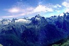
Parorama from Harris Saddle
Photograph
•
Distance: 8.3km away
several photographs put together to create a panoramic view
More ▶︎

Haast to The Divide
GPX file
•
Distance: 8.3km away
Andrew Barker's traverse 2009. From Pleasant Flat in the Haast to The Divide via Mt Aspiring National Park.
More ▶︎
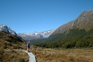
Key Summit
Track
•
Easy. Return via same track.
•
Distance: 8.4km away
Short, easy walk at the start of the Routeburn Track to a low summit. Panoramic views of the Greenstone, Hollyford, ...
More ▶︎
Not The Routeburn
GPX file
•
Distance: 8.4km away
A six-passes, seven catchments trip through the Humboldt Mountains from Glenorchy to The Divide.
Note that for access from Double Barrel ...
More ▶︎
Caples Track
Track
•
2 days. Easy/medium. One way.
•
Distance: 8.4km away
A quiet track climbing alongside the Caples River through forest and grassy flats and over a sub-alpine saddle.
More ▶︎
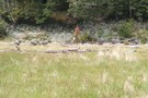
Caples Valley Fallow Deer
Photograph
•
Distance: 8.4km away
Spooked a mob of 30+ deer back in 06/07.
More ▶︎
Greenstone Saddle Camping Area
Campsite
•
Informal campsite (DOC).
•
Distance: 8.9km away
Large informal campsite at Greenstone Saddle, near the top of the Greenstone Track.
More ▶︎
Morning at the Greenstone Saddle Camping Area.
Photograph
•
Distance: 9.0km away
Morning at the Greenstone Saddle Camping Area. McKellar Saddle, cloaked in cloud and dusted with snow, is left of centre.
More ▶︎
The Divide Shelter
Hut
•
Shelter (DOC).
•
Distance: 9.3km away
Open shelter at the Milford end of the Routeburn Track. Overnight use prohibited.
More ▶︎
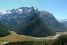
Lake Howden
Photograph
•
Distance: 9.6km away
Summer at Lake Howden is a magic time. The wind is warm, days are hot and sunny, and the fellow ...
More ▶︎
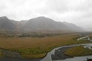
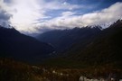
Hollyford Valley
Photograph
•
Distance: 9.7km away
The Hollyford Valley floor sits just above sea level, while the Routeburn Track creeps along the Serpentine Range at around ...
More ▶︎
Howden Hut
Hut
•
Great Walks Hut (DOC). Capacity: 28.
•
Distance: 9.7km away
Hut on the Routeburn Track, destroyed by a landslide in February 2020.
More ▶︎
Lake Marian
Track
•
Easy/medium. Return via same track.
•
Distance: 9.8km away
Short walk from the Hollyford Road up to a hanging valley and lake in the Darran Mountains.
More ▶︎