Nearby
Paparoa Track
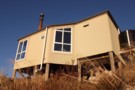
Moonlight Tops Hut
Hut
•
Great Walks Hut (DOC). Capacity: 20.Bookings required.
•
Distance: less than 100m away
Hut servicing the Paparoa Track, located above the treeline on the Paparoa Range.
More ▶︎
Pororari Hut
Hut
•
Great Walks Hut (DOC). Capacity: 20.Bookings required.
•
Distance: less than 100m away
Hut servicing the Paparoa Track, located on a low ridge between the catchments of the Pororari and Punakaiki Rivers.
More ▶︎
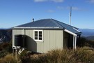
Ces Clark Hut
Hut
•
Great Walks Hut (DOC). Capacity: 16.Bookings required.
•
Distance: less than 100m away
This hut on the Paparoa Track was constructed in 1986. It is named after NZ Forest Service Ranger Ces Clark ...
More ▶︎
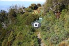
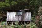
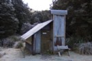
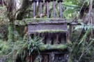
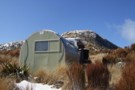
Ces Clark hut 2010
Photograph
•
Distance: less than 100m away
Partial view of hut. Looking NE toward Moonlight Creek headwaters.
More ▶︎
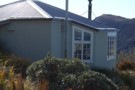
Ces Clark hut Aug 2010
Photograph
•
Distance: less than 100m away
A nice hut with good views. Built in 1986 & situated just above the bushline. It is just above the ...
More ▶︎
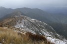
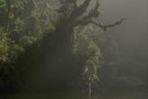
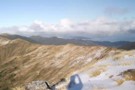
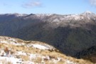
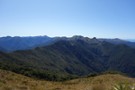
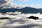
Paparoa Range tops above Moonlight Creek July 2011
Photograph
•
Distance: less than 100m away
This pic was taken off point 1104m on the crest of the Paparoa Range and looks ENE. The foreground ridge ...
More ▶︎
Croesus Top Hut
Hut
•
Basic Hut/Bivvy (DOC). Capacity: 3.
•
Distance: less than 100m away
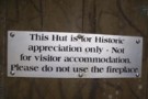
The hut that was superceeded by the Ces Clark Memorial hut.
Top Hut is still there & sits just below the ...
More ▶︎

Ces Clarke Hut
Photograph
•
Distance: less than 100m away
12-bunk, architecturally designed cosy cabin overlooking the Grey River valley. Positioned at the southern end of the rugged Paparoa National ...
More ▶︎
Pororari River Track
Track
•
Easy. Return via same track.
•
Distance: 298m away
An easy stroll along the banks of the beautiful Pororari River.
More ▶︎
Paparoa National Park
Place
•
National Park. 305.60km2.
•
Distance: 905m away
A land of cliffs, gorges, caves, and disappearing rivers, draped in rich coastal forest.
More ▶︎
Ces Clark Hut
Photograph
•
Distance: 980m away
a serviced 16 bunk hut with coal burner on Croesus track
More ▶︎

Croesus Track
Track
•
2 days. Easy. One way.
•
Distance: 980m away
An easy route onto the alpine landscape of the Paparoa Ranges along an historic mining road.
More ▶︎
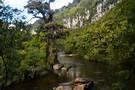
Pororari River
Photograph
•
Distance: 1.0km away
This river at Punakaiki is popular with canoes, and has an easy walking track.
More ▶︎
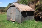
Meikles Hut
Hut
•
Basic Hut/Bivvy (DOC). Capacity: 2.
•
Distance: 1.1km away
Meikles hut is derelict, and a DOC sign warns, "Building unsafe. No Entry."
The first Meikles Hut was an historic ...
More ▶︎
Meikles hut July 2011
Photograph
•
Distance: 1.1km away
This pic is taken from the short branch track off the Moonlight track as you approach the hut from below. ...
More ▶︎
Croesus Knob
Photograph
•
Distance: 1.2km away
from top of Cresus knob, about 45 min walk from Ces Clark hut
More ▶︎
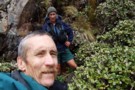
alpine & glennj in head of Ten Mile Creek, Paparoa Range
Photograph
•
Distance: 1.3km away
This Dec 2012 pic shows a couple of Croesus area vets outside a mine adit (tunnel entrance) on the NW ...
More ▶︎
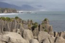
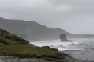
Pancake Rocks
Photograph
•
Distance: 1.3km away
The famous Pancake Rocks at Punakaiki. The alternating layers of limestone and mudstone are formed in a process called stylobedding.
More ▶︎
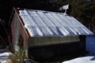
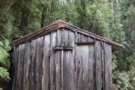
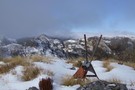
Garden Gully hut July 2011
Photograph
•
Distance: 1.3km away
Garden Gully hut a couple of days after a snowfall.
More ▶︎
Garden Gully Hut
Hut
•
Basic Hut/Bivvy (DOC). Capacity: 4.
•
Distance: 1.3km away
Sack bunks,calico windows, pretty basic.
This is a reconstructed/replica "Depression Era" miners hut.
Back in the 70's this hut was totally ...
More ▶︎
Garden Gully hut Aug 2010
Photograph
•
Distance: 1.3km away
A replica miners hut built on the site of an old miners camp. It is a few minutes along the ...
More ▶︎
Truman Track
Track
•
Easy. Return via same track.
•
Distance: 1.4km away
Visit coastal platforms and caves near Punakaiki.
More ▶︎
Wild coastline at the end of the Truman Track
Photograph
•
Distance: 1.4km away
The short track passes through coastal podocarp forest, harakeke scrub, coastal herbfields, and down to a sculpted gravel beach.
More ▶︎
Meikles hut Moonlight track July 2011
Photograph
•
Distance: 1.4km away
This historic hut is derelict. Some people still use it as a place to stop for a boil up using ...
More ▶︎
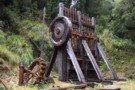
Garden Gully Stamper Battery Sept 2012
Photograph
•
Distance: 1.6km away
This battery which crushed quartz to enable the extraction of gold is a few minutes beyond Garden Gully hut. A ...
More ▶︎
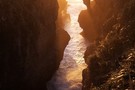
Inland Pack Track
Track
•
2 – 3 days. Easy. One way.
•
Distance: 2.0km away
A beautiful historic route through a coastal karst environment. Gorges, caves, waterfalls, subterranean rivers, sink-holes, swimming, and camping beneath a ...
More ▶︎
Dolomite Point Walk
Track
•
Easy. Return via same track.
•
Distance: 2.2km away
The famous Punakaiki Pancake Rocks. Blowholes, sea cliffs.
More ▶︎
Formerly the Knobby Ridge biv Oct 2011
Photograph
•
Distance: 2.3km away
We saw this biv when emerging from the Inland Pack Track on to the farm track that runs beside the ...
More ▶︎
Former Knobby Ridge Biv
Hut
•
Basic Hut/Bivvy (DOC).
•
Distance: 2.3km away
Originally located on Knobby Ridge, overlooking the Hokitika Gorge, this biv was removed by DOC for a radio base station ...
More ▶︎
Sunset, Pancake Rocks
Photograph
•
Distance: 2.4km away
The Pancake Rocks are layers of limestone where impurities have separated out into horizontal seams -- a process known as ...
More ▶︎
Taffy Battery Ten Mile Creek Dec 2017
Photograph
•
Distance: 2.7km away
I located the battery remains last month after tramping in from the Croesus Track Smoke Ho carpark near Blackball. The ...
More ▶︎
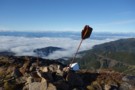
Croesus Track, Knob etc Sept 2012
Photograph
•
Distance: 2.9km away
This photo looks westward from Point 1074m on the tops dividing the Moonlight & Croesus tracks. You can see the ...
More ▶︎
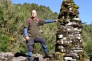
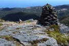
Large cairn beside the Moonlight track Sept 2012
Photograph
•
Distance: 3.1km away
This pic shows JH posing beside a large cairn next to the Moonlight track. The cairn sits on and is ...
More ▶︎
From Mt Watson
Photograph
•
Distance: 3.1km away
This autumn morning photo shows the remains of one of the old trig beacons on Mt Watson and looks out ...
More ▶︎
Mt Leitch Bivvy Sept 2015
Photograph
•
Distance: 3.7km away
This bivvy is situated in the tussock near the bush edge high on the western flank of Mt Leitch in ...
More ▶︎
NE from Mt Hawera - Paparoa Range
Photograph
•
Distance: 4.3km away
This photo was taken from a little NE of the the summit of Hawera (1190m) and looks NE toward Mts ...
More ▶︎
Cave Creek / Kotihotiho Track
Track
•
Easy. Return by the same track.
•
Distance: 5.5km away
Scenic walk to the resurgence of Cave Creek.
More ▶︎
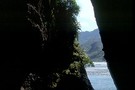
Cave Creek
Photograph
•
Distance: 5.5km away
Cave Creek emerges out of the ground and connects up with the Pororari River.
More ▶︎
Impressive Beehive Cairn Paparoa Range
Photograph
•
Distance: 6.0km away
My photo doesn't do the cairn justice. This beehive shaped cairn is about 2 metres high. From the north it ...
More ▶︎
Cloud across Paparoa from camp on Bovis
Photograph
•
Distance: 7.8km away
Oh Tangaroa, what my eyes tell me is that today is another show off day...(Tuwhare)
More ▶︎
Mt Bovis
Photograph
•
Distance: 7.8km away
Tarn at 1020m elevation, south of peak
Topomap BS20 coord. 751 359
More ▶︎
Mount Bovis
Track
•
1 day. Medium/hard. Return by the same track.
•
Distance: 8.1km away
Day trip to a 1252m summit off the Paparoa Range behind Bullock Creek farm.
More ▶︎
View SE from Mt Bovis August 2011
Photograph
•
Distance: 8.1km away
This pic shows the fallen down trig on the summit of Bovis and looks in a south easterly direction toward ...
More ▶︎
Fox River Caves
Track
•
Easy. Return via same track.
•
Distance: 8.9km away
Deep caves in the wall of a limestone gorge.
More ▶︎

Te Ana o Matuku Cave
Photograph
•
Distance: 9.1km away
Teorumata Cave at the mouth of the Fox River is carved out of Hawk's Crag breccia.
More ▶︎
Te Ana o Matuku Cave
Track
•
Easy. Return by the same track.
•
Distance: 9.2km away
An historic cave on the Paparoa National Park coastline.
More ▶︎
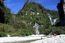
Ballroom, Fox River
Track
•
1 – 2 days. Easy. Return via same track.
•
Distance: 9.2km away
Walk through a spectacular limestone gorge, visit caves, and camp under a massive rock overhang.
More ▶︎
Fox River Cave
Photograph
•
Distance: 10.0km away
Bring a strong torch to explore this cave.
More ▶︎
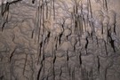
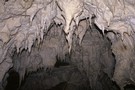
Soda straws, Fox River Cave
Photograph
•
Distance: 10.0km away
A soda straw is left behind by drops of water. Just before the water falls, it forms a hollow shape ...
More ▶︎