Nearby
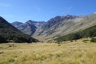
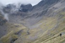
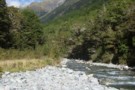
Rainbow valley
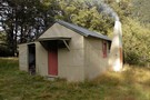
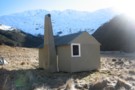
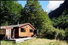
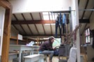
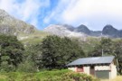
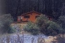
Begley Hut
Hut
•
Standard Hut (DOC). Capacity: 8.
•
Distance: 4.5km away
An old NZ Forest Service hut up the Begley Valley. Fire doesn't draw well and door has to be left ...
More ▶︎
Begley Hut
Photograph
•
Distance: 4.5km away
An old NZ Forest Service hut up the Begley Valley. Fire doesn't draw well and door has to be left ...
More ▶︎
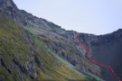
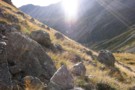
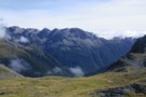
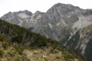
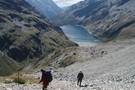
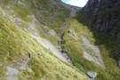
Rainbow Pass from the south
Photograph
•
Distance: 4.7km away
Rainbow Pass: a steep, tricky pass with serious exposure. I took the green route shown ... the red may, or ...
More ▶︎
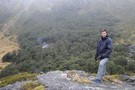
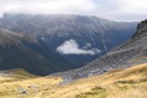
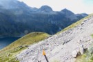
Travers Pass
Photograph
•
Distance: 4.7km away
Looking down onto Travers Pass from Rainbow Pass. The main track is on the far side.
More ▶︎
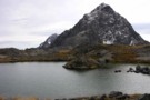
Paske Hut
Photograph
•
Distance: 4.8km away
Paske Hut and the towering walls of the head basin beyond. The two valley cutting left lead to the Paske-Clarence ...
More ▶︎
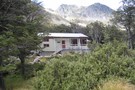
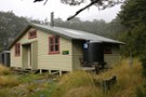
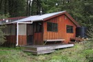
Paske Hut
Hut
•
Standard Hut (DOC). Capacity: 6.
•
Distance: 5.0km away
Hut in the headwaters of Paske Creek, beneath the St Arnaud Range. Passes beyond the hut lead into the head ...
More ▶︎
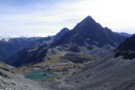
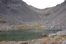
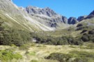
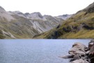
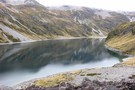
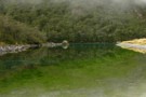
Rainbow Tarn
Photograph
•
Distance: 5.2km away
the tarn below Rainbow Pass, looking to Mt Travers - Apr 2011
More ▶︎
Rainbow Pass
Photograph
•
Distance: 5.3km away
looking across the tarn, the climb to the top of the pass is steeper than it looks in this photo ...
More ▶︎
Clarence Pass
Photograph
•
Distance: 5.5km away
Climbing towards Clarence Pass from the East Branch of the Sabine River.
More ▶︎

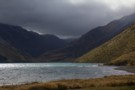
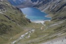
Lake Thompson
Photograph
•
Distance: 5.6km away
A view of the beautiful Lake Thompson, a short distance from Thompson Pass
More ▶︎

Route Guide: St Arnaud to Lewis Pass
Article
•
Distance: 5.6km away
A 5-7 day north-south route from St Arnaud to the Lewis Pass, via Travers Pass, Waiau Pass, Thompson Pass and ...
More ▶︎
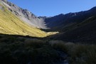
Upper Travers Basin
Photograph
•
Distance: 5.6km away
The pot belly stove in the new hut at Upper Travers got a strong workout in the winter of 2004. ...
More ▶︎
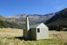
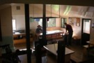
Upper Travers Hut
Hut
•
Serviced Hut (DOC). Capacity: 24.
•
Distance: 5.6km away
The original hut has been replaced by a larger hut. The new hut is in the shelter of the trees ...
More ▶︎
Mt Travers
Photograph
•
Distance: 5.6km away
Mt Travers from Upper Travers Hut - 2338m - Apr 2011
More ▶︎
Picton to Aspiring
GPX file
•
Distance: 5.6km away
An aborted alpine traverse. Picton to West Cape, but aborted at Aspiring due to real world emergencies back home. Posted ...
More ▶︎
Travers Pass
Photograph
•
Distance: 5.6km away
beginning of the climb to Travers Pass, looking down the Travers Valley - Apr 2011
More ▶︎
Travers Pass
Photograph
•
Distance: 5.8km away
final ascent to Travers Pass - Mt Travers in the background - Apr 2011
More ▶︎
Phil and Lori at Travers Saddle
Photograph
•
Distance: 5.9km away
A couple of American trampers I met back in 06. Soon after this crossing we got hit by a bit ...
More ▶︎
Phil and Lori at Travers Saddle
Photograph
•
Distance: 5.9km away
A couple of American trampers I met back in 06. Soon after this crossing we got hit by a bit ...
More ▶︎
Waiau - Clarence Pass Lake Tennyson Circuit
Track
•
4 – 5 days. Medium/hard. Loop track.
•
Distance: 5.9km away
A challenging 4-5 day circuit in the St. James Conservation Area / Nelson Lakes National Park featuring two alpine pass ...
More ▶︎
Travers-Sabine Saddle
Photograph
•
Distance: 6.1km away
Going over the saddle looking west towards the Sabine Valley - April 2010.
More ▶︎
Travers-Sabine
Track
•
4 – 7 days. Medium. Loop track with a road section.
•
Distance: 6.1km away
Two river valleys linked by a straightforward alpine saddle at 1800m
More ▶︎
Upper Travers Hut
Photograph
•
Distance: 6.1km away
Upper Travers Hut with Travers Pass beyond, Nelson Lakes
More ▶︎
Mt Franklin
Photograph
•
Distance: 6.9km away
taken on the descent from Travers Pass into the E Sabine River - Apr 2011
More ▶︎
Molesworth Recreation Reserve
Place
•
Reserve. 1807.87km2.
•
Distance: 8.3km away
An iconic high country station located behind the Kaikoura Ranges.
More ▶︎
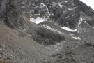
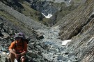
Wairau-Paske saddle
Photograph
•
Distance: 8.9km away
The saddle at the head of the Wairau, crossing into the Paske. Tiring climbing on loose scree, but a non-technical ...
More ▶︎
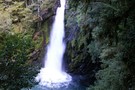
Travers Waterfall
Photograph
•
Distance: 9.0km away
a 15m fall - just a few minutes off the main Travers track (sign-posted) - Apr 2011
More ▶︎
Travers Falls
Place
•
Place.
•
Distance: 9.0km away
The whole of the Travers River funnels through this narrow slit - must be awesome after heavy rain.
About 1km upstream ...
More ▶︎
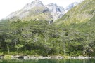
Lake Constance
Photograph
•
Distance: 9.1km away
View down to Lake Constance from Waiau Pass
More ▶︎
Lake Constance
Photograph
•
Distance: 9.1km away
Looking south across the lake to Waiau Pass. The southern end of the lake is dammed by an ancient, massive ...
More ▶︎
Lake Constance
Photograph
•
Distance: 9.1km away
From the ascent to Waiau Pass.
Looking down the West Sabine valley.
More ▶︎
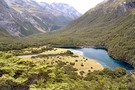
Blue Lake Jan 2007
Photograph
•
Distance: 9.3km away
This was a 'rite-of-passage' tramp for my 13 year old son. We helicoptered in to the Waiau Pass and then ...
More ▶︎
Sabine Valley - Blue Lake - D'Urville Valley
Track
•
4 – 5 days. Medium. Circuit.
•
Distance: 9.3km away
A circuit along neighbouring valleys at the hear of Lake Rotoroa, passing the picturesque Blue Lake, and crossing Moss Pass. ...
More ▶︎
Blue Lake
Track
•
2 – 4 days. Easy/medium. Return via same track.
•
Distance: 9.3km away
Blue Lake is a small, pretty lake dammed by boulders at the head of the Sabine Valley. Beyond is Lake ...
More ▶︎
Lake Constance
Photograph
•
Distance: 9.4km away
from the bolder field above the lake, near the track to Waiau Pass - Apr 2011
More ▶︎
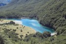
Blue Lake
Photograph
•
Distance: 9.4km away
Tiny Blue Lake viewed from the track to Lake Constance.
More ▶︎
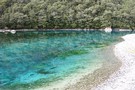
Blue Lake
Photograph
•
Distance: 9.5km away
considering the grey skies at the time, Blue Lake lives up to the name - and throws in some irridescent ...
More ▶︎
Blue Lake, Nelson Lakes
Photograph
•
Distance: 9.5km away
Blue Lake in the Nelson lakes. Viewed from the moraine wall below Lake Constance.
More ▶︎

Blue Lake Hut - Bobs Hut
GPX file
•
Distance: 9.5km away
Blue Lake campsite to Bob’s Hut, via Lake Thompson and D’Urville Pass
An actual, recorded, gpx – the high route section ...
More ▶︎
descent to the head of Lake Constance
Photograph
•
Distance: 9.5km away
after sidling across tussock grass, the descent from the bluff above the lake is pretty much tracked - and poled ...
More ▶︎
St Arnaud - Lewis Pass
Article
•
Distance: 9.5km away
A 9-day 100km tramp via the Thompson, D'Urville and 3 Tarns Passes
Feb 2013
More ▶︎
Blue Lake campsite
Photograph
•
Distance: 9.5km away
nestled in and around a clump of trees, in front of the lake - Feb 2013
More ▶︎

Profile : St Arnaud - Lewis Pass
Photograph
•
Distance: 9.5km away
A useful profile of the 100km tramp - with a couple of bad weather alternatives :
1. low route past Speargrass ...
More ▶︎
Sidling above Lake Constance
Photograph
•
Distance: 9.6km away
recent discussion about the track above Lake Constance (Campfire forum, Lake Constance - Waiau Pass Safety topic) has prompted me ...
More ▶︎
St Arnaud to Lewis Pass
Track
•
5 – 9 days. Medium/hard. One way.
•
Distance: 9.6km away
A 5-9 day north-south route from St Arnaud to the Lewis Pass, via Travers Pass, Waiau Pass, Thompson Pass and ...
More ▶︎
Blue Lake
Photograph
•
Distance: 9.6km away
at the outlet end, the greens of Blue Lake dominate - considering the mists hovering above, the colour is indeed ...
More ▶︎

Island Gully Hut
Hut
•
Standard Hut (DOC). Capacity: 4.
•
Distance: 9.7km away
DOC Hut sited approx 200m off the Hanmer Springs-St. Arnaud Rd, which is a toll/gravel road. Features four bunks and ...
More ▶︎
Nelson Lakes double figure eight with a reverse twist
Article
•
Distance: 9.7km away
January 2008.
A seven day epic up and over Lake Angelus from Speargrass Hut, then up the Sabine River, over Waiau ...
More ▶︎
Drying Out
Photograph
•
Distance: 9.7km away
Got drenched on the way up to Blue Lake Hut.
Tried to dry out once we'd gotten the stove alight.
More ▶︎
Blue Lake Hut Panorama
Photograph
•
Distance: 9.7km away
Taken outside Blue Lake Hut, Nelson Lakes NP.
Moss Pass is up there somewhere, but our route was past Lake Constance ...
More ▶︎
Blue Lake Hut
Photograph
•
Distance: 9.7km away
popular in season, this is a busy spot - although there is always floor-space at least, a tent is highly ...
More ▶︎
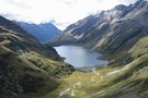
Lake Constance
Photograph
•
Distance: 9.8km away
Lake Constance, Nelson Lakes National Park. taken part way up to Waiau pass March 2003.
More ▶︎
West Sabine River
Photograph
•
Distance: 9.8km away
West Sabine River, below West Sabine Hut, Nelson lakes
More ▶︎
West Sabine Hut
Hut
•
Serviced Hut (DOC). Capacity: 34.
•
Distance: 9.9km away
Located in the West Branch of the Sabine River, south of Lake Rotoroa.
More ▶︎
West Sabine Hut
Photograph
•
Distance: 9.9km away
April 2010 - small wood burner inside....but sufficient
More ▶︎
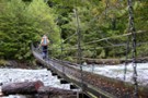
previous West Sabine bridge
Photograph
•
Distance: 10.0km away
washed away in 2012 and replaced with one just upstream of West Sabine hut
More ▶︎