Nearby
Number 1 dam on the Mangahao River
Tararua main ridge
Track
•
4 – 8 days. Medium. One way.
•
Distance: 3.2km away
The length of the tracked Tararuas along the main ridge from Mangahao (behind Shannon) to Kaitoke.
For a 'Total Tararua Traverse ...
More ▶︎
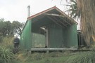
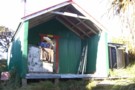
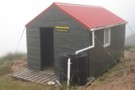
Burn Hut
Photograph
•
Distance: 3.6km away
Burn Hut in the Mangahao catchment, Northern Tararua Range. A good loop is from the number 2 dam downriver to ...
More ▶︎
A Total Tararua Traverse
Track
•
8 – 16 days. Medium. One way.
•
Distance: 3.6km away
The length of the Tararuas via the pointy bits, from the Manawatu Gorge at Woodville to the Rimutaka Hill Road ...
More ▶︎
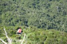
Burn Hut
Photograph
•
Distance: 3.6km away
Burn Hut. 2 hours from Mangahoa Dam 2, near Shannon
More ▶︎
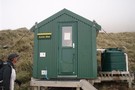
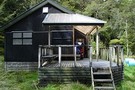
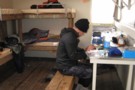
Burn Hut
Hut
•
Basic Hut/Bivvy (DOC). Capacity: 6.
•
Distance: 3.6km away
Cool wee hut sitting on the tops a few hours from Mangahoa Dam 2, near Shannon. Great view. Walk in ...
More ▶︎
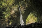
Ruapae Falls Tararua's
Photograph
•
Distance: 5.4km away
Ruapae Falls are in the headwaters of the Magatainoka River near Eketahuna. The falls can be reached by following the ...
More ▶︎
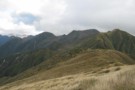
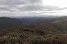
Dundas Ridge from West Peak
Photograph
•
Distance: 6.4km away
The view along the backbone of the Dundas ridge from West Peak, showing Walker, Dome and Pukemoremore
More ▶︎
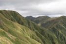
Saddle between East Peak and West Peak Northern Tararua
Photograph
•
Distance: 6.5km away
The Saddle between East Peak and West Peak, Dundas Ridge, Northern Tararua . With Walker and Pukemoremore beyond .
More ▶︎
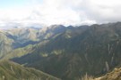
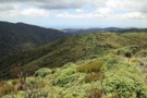
Interior of the Northern Tararua Range
Photograph
•
Distance: 6.5km away
The view from East Peak looking into the heart of the Northern Tararua range . Showing The Dundas ridge to ...
More ▶︎
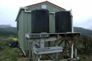
Herepai Hut
Hut
•
Standard Hut (DOC). Capacity: 10.
•
Distance: 6.7km away
An older huts lower than the bush line. It has a cast-iron fire, two platforms for sleeping quarter. It holds ...
More ▶︎
Herepai Hut
Photograph
•
Distance: 6.8km away
Herepai Hut from the ridge up to Herepai - February 2007
More ▶︎
North Tararua (Hardings Park) Tracks
GPX file
•
Distance: 7.2km away
Tracks,routes and cut stoat lines in the area between South Range Road and the Mangahao.
A mixture of GPS created files, ...
More ▶︎
Mangahao Flats Hut
Hut
•
Standard Hut (DOC). Capacity: 16.
•
Distance: 7.8km away
A huge modern hut put in between (now removed) Harris Creek Hut and (now removed) Avalanche Flats Hut. Approximately five ...
More ▶︎
Herepai Hut
Photograph
•
Distance: 7.9km away
Nice 10 bunk hut, Steady climb up but well worth it with the tops only an hour walk away
More ▶︎

Mangahao Vally Bush
Photograph
•
Distance: 8.2km away
About an hour South of Mangahao Hut, the bush is wet and damp, with mud up to your knees. Fantastic.
More ▶︎
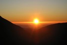
Sunrise from Dundas Hut
Photograph
•
Distance: 9.2km away
Sunrise from Dundas Hut - February 2007
More ▶︎
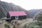
Dundas Hut
Hut
•
Standard Hut (DOC). Capacity: 6.
•
Distance: 9.2km away
Dundas Hut (4 bunk) sits in one of the best spots of any hut in the North Island. It perches ...
More ▶︎
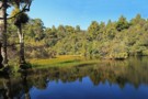
Hidden Lake Tararua Ranges -1
Photograph
•
Distance: 9.3km away
Hidden Lake is about 35 to 45 minutes upstream from Roaring Stag Lodge in the Tararua's. It is situated on ...
More ▶︎
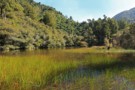
Hidden Lake Tararua Ranges
Photograph
•
Distance: 9.3km away
Hidden Lake is about 35 to 45 minutes upstream from Roaring Stag Lodge in the Tararua's. It is situated on ...
More ▶︎