Nearby
Otukaikino Reserve
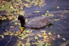
Waimairi Walkway
Track
•
Easy. Loop track.
•
Distance: 1.6km away
Farm walking, birdlife, picnicking, swimming, and hydrological ponderings.
More ▶︎
Christchurch 360 Trail: Brooklands Mouth
GPX file
•
Distance: 1.9km away
Section of the Christchurch 360 Trail, starting at Spencer Park, Heyders Road, Bottle Lake.
More ▶︎
Christchurch 360 Trail: Waimakariri Braids
GPX file
•
Distance: 1.9km away
Section of the Christchurch 360 Trail, starting at The Groynes, Groynes Drive, Northwood.
More ▶︎
Kaiapoi Island Trail
Track
•
1 day. Easy. Loop track.
•
Distance: 2.1km away
A long flat loop next to the Waimakariri River.
More ▶︎
Christchurch 360 Trail: Dunes Wetlands
GPX file
•
Distance: 4.9km away
Section of the Christchurch 360 Trail, starting at the Avon River Bridge, Pages Road, Bexley.
More ▶︎
Waimakariri Walk
Track
•
Easy. Loop track.
•
Distance: 5.1km away
A rather plain walk along the Brooklands Spit between lagoon and ocean.
More ▶︎
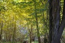
Kaiapoi - Pegasus Bay Walkway
Track
•
Easy/medium. One way.
•
Distance: 5.7km away
A pleasant river-side stroll coupled with a less than pleasant coastal plantation ramble.
More ▶︎
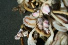
Barnacles
Photograph
•
Distance: 6.2km away
Living pink barnacles on sea tulips, Pegasus Bay.
More ▶︎
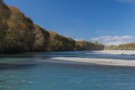
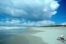
Pegasus Bay near Brooklands Lagoon
Photograph
•
Distance: 6.2km away
The long straight beach south of the Waimakariri River.
More ▶︎
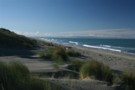
Halfway mark
Photograph
•
Distance: 6.2km away
Halfway along the Brooklands Spit: a perfect spot to climb over the dune and see what the ocean is doing.
More ▶︎
Waimakariri River Regional Park
Place
•
Local Park or Reserve. 150.00km2.
•
Distance: 6.3km away
A multipurpose recreational park located on the lower Waimakariri River north of Christchurch.
More ▶︎
Tūhaitara Coastal Park
Place
•
Reserve. 5.75km2.
•
Distance: 7.3km away
A block of coastal land between the Ashley / Rakahuri and Waimakariri Rivers north of Christchurch.
More ▶︎