Nearby
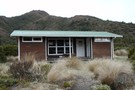
Waipakihi Hut
Waipakihi Hut
Hut
•
Standard Hut (DOC). Capacity: 12.
•
Distance: less than 100m away
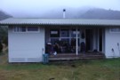
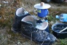
Very tidy hut situated on a bench above the Waipakihi River on a Sunny day this would be a great ...
More ▶︎
Waipakihi Hut
Photograph
•
Distance: less than 100m away
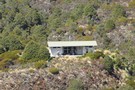
A telephoto shot of Waipakihi Hut as you approach it from Umukarikari
More ▶︎

Urchin - Waipakihi Hut - Umukarikari - GPX
GPX file
•
Distance: less than 100m away
A GPX file of this classic trip
More ▶︎
Waipakihi Thunderbolt Loop
GPX file
•
Distance: less than 100m away
A 3 day loop in the Kaimanawas with a lot of enjoyable tops travel
More ▶︎
Waipakihi Thunderbolt Loop
Track
•
3 days. Medium. Loop track with a road section.
•
Distance: less than 100m away
A 3 day trip in the Kaimanawas following the Middle Range and enjoyable tops tramping. Also a probable night camping ...
More ▶︎
Waipakihi Hut
Photograph
•
Distance: less than 100m away
A great hut in the heart of the Kaimanawa Ranges.
More ▶︎
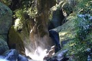
Aproaching Waipakihi Hut
Photograph
•
Distance: less than 100m away
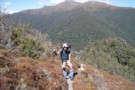
It is a long haul up the Waipakihi River and you are wondering how long it will be, when suddenly ...
More ▶︎
Waipakihi Hut to Middle Range
Track
•
Medium. One way.
•
Distance: less than 100m away
DOC have re cut an old track that gives access to the Middle Range from Waipakihi Hut. The usual route ...
More ▶︎
Urchin - Waipakihi Hut - Umukarikari Trip
Track
•
2 – 3 days. Easy/medium. Loop track with a road section.
•
Distance: less than 100m away
A classic 2 - 3 day trip in the Kaimanawas. Includes open tops, river travel and a comfy hut for ...
More ▶︎
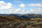
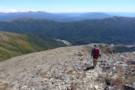
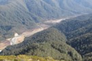
Above Waipakihi Hut
Photograph
•
Distance: 864m away
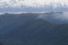
Looking down towards Waipakihi Hut from near the end of the Umukarikari Track.
More ▶︎
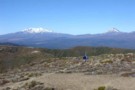
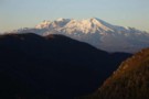
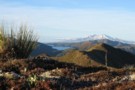
Mt Ruapehu with the Waipakihi River in the foreground
Photograph
•
Distance: 2.0km away
Ruapehu dominates the view from the western Kaimanawas
More ▶︎
Kaimanawa Forest Park - East Taupo Lands Trust Boundary
GPX file
•
Distance: 2.5km away
I like to have this track loaded into my GPS whenever I am in the Kaimanawas because the boundary is ...
More ▶︎
3kgs of ice...
Photograph
•
Distance: 3.2km away
It was a tad cold... Hard to get the feet into solid boots
More ▶︎

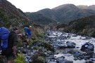
Reflections of Sue in the Waipakihi River
Photograph
•
Distance: 4.2km away
One of many river crossing in the Waipakihi
More ▶︎
Let the eye and mind wander
Photograph
•
Distance: 4.2km away
A view that got me, the eye drifts all across the tops to future adventures
More ▶︎
Urchin-Umukarikari
GPX file
•
Distance: 5.3km away
This is a new track, it has only just been cut through the bush between Urchin and Umukarikari. It is ...
More ▶︎
on the ridge
Photograph
•
Distance: 5.3km away
Photograph was taken in the late afternoon while slowly approaching Waipakihi hut in the valley.
More ▶︎
Urchin-Umukarikari Loop Track
Track
•
1 – 2 days. Medium. Loop track with a road section.
•
Distance: 5.3km away
This is a new track linking the existing Umukarikari Track that goes to Waipakihi Hut with the Urchin Track that ...
More ▶︎
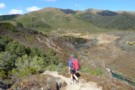
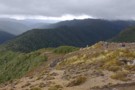
Perfect weather in the Kaimanawas
Photograph
•
Distance: 6.2km away
One of the greatthings about the walk up Umukarikari is the view. That is if you are lucky enough to ...
More ▶︎

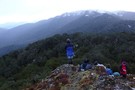
Sue on the summit of Thunderbolt
Photograph
•
Distance: 6.8km away
Thunderbolt is just another bump on the ridge but because it has a name is a cause for celebration
More ▶︎
Looking west from Thunderbolt towards the Waipakihi
Photograph
•
Distance: 6.8km away
Ridge top travelling in the Kaimanawas is bliss on a perfect day
More ▶︎
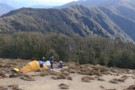
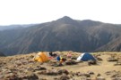
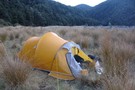
Camping on the Tops
Photograph
•
Distance: 6.9km away
A great place to be if the weather is good and you can find some water
More ▶︎
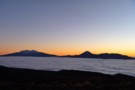
Ruapehu at Sunrise from the Kaimanawa Tops
Photograph
•
Distance: 6.9km away
We were camping out in the Kaimanawas in perfect weather and got this view of Ruapehu as the sun was ...
More ▶︎
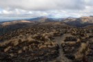
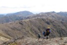
Kaimanawa Tops
Photograph
•
Distance: 7.0km away
Looking from the Umukarikari end along the bush ridge towards Urchin. A new track has just been cut along this ...
More ▶︎
Tops camping in the Kaimanawas
Photograph
•
Distance: 7.2km away
Not a bit of shelter from the wind, but who needs it today.
More ▶︎
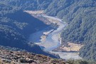
Waipakihi and Ruapehu
Photograph
•
Distance: 8.1km away
Looking down a mist-filled Waipakihi valley with Ruapehu in the background. Taken from near Ngapuketurua January 2008.
More ▶︎
Thunderbolt track now easy to find
Photograph
•
Distance: 8.3km away
For many years the track to Thunderbolt has not been easy to find. The position is also wrongly depicted on ...
More ▶︎
Email from doc Turangi re the East Taupo Lands Block
Article
•
Distance: 8.4km away
An email received from Terry Slee at DOC Turangi regarding their negotiations with the East Taupo Lands Trust regarding access
More ▶︎
Kaimanawa Forest Park
Place
•
Conservation Park. 763.48km2.
•
Distance: 8.4km away
Mountain wilderness east of Tongariro National Park. Highest point: 1727m (Makorako).
More ▶︎
Descending Middle Range
Photograph
•
Distance: 8.4km away
At the western end of Middle Range in the Kaimanawas, taken from Motutere. Mt Ngauruhoe and Urchin to the left.
More ▶︎

Camp on the saddle just past Thunderbolt
Photograph
•
Distance: 8.6km away
Beautiful spot to bask in the afternoon sun!
More ▶︎
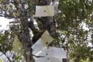
Marker Tree
Photograph
•
Distance: 8.6km away
Generations of markers mark the spot where the Tunderbolt Track enters the bush at bushline
More ▶︎
Looking down into the Waipakihi from the slopes of Motutere
Photograph
•
Distance: 8.7km away
The route into the valley heads down this bush ridge then veers off the left. That is Umukarikari beyond
More ▶︎
Lower Waipakihi Valley
GPX file
•
Distance: 9.5km away
The route down the lower Waipakihi just follows the river. You can cut off about 5 minutes at the point ...
More ▶︎
Lower Waipakahi Valley
Track
•
1 – 2 days. Easy/medium. One way.
•
Distance: 9.5km away
A nice easy valley with very pleasant camping all the way along its length
More ▶︎
Waipakihi Valley from the Urchin Ridge
Photograph
•
Distance: 9.9km away
The is the first view you get of the Waipakihi Valley from the Urchin Ridge
More ▶︎