Nearby
Craigieburn Forest Park
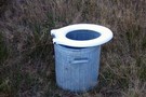
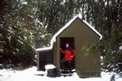
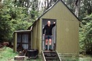
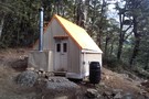
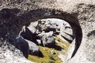
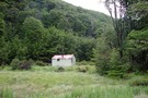
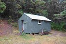
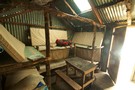
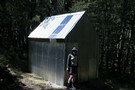
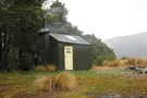
Bush toilet
Photograph
•
Distance: less than 100m away
I found this toilet when I was camping at the start of the Cass saddle track and thought it would ...
More ▶︎
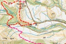
Cass-Lagoon Saddle
Track
•
2 days. Medium. One way.
•
Distance: less than 100m away
This classic route from Cass to Cora Lynn Road circles the Black Range to form an open loop, and a ...
More ▶︎
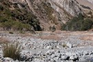
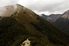
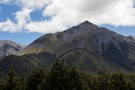
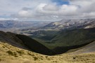
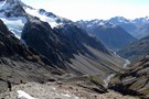
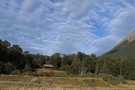
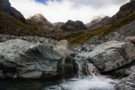
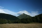
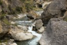
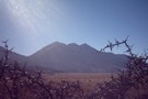
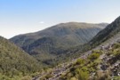
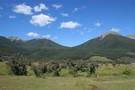
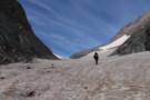
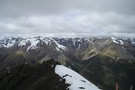
Cass Saddle
Photograph
•
Distance: less than 100m away
Looking across the Cass Saddle from ridge on North Side.
More ▶︎
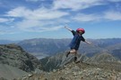
Thesis Pk – indiretissima
Article
•
Distance: less than 100m away
A wander up the attractive Centre Creek off the Avoca valley to climb Thesis Pk the longer way.
More ▶︎
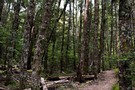
Helicopter Hill Circuit
Track
•
Easy/medium. Loop track.
•
Distance: less than 100m away
This circuit in Craigieburn Forest Park knits together several different tracks, and visits the summit of Helicopter Hill (1256m).
More ▶︎
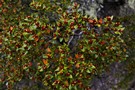
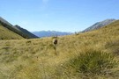
Beech flowers
Photograph
•
Distance: 147m away
Bright red mountain beech flowers on Helicopter Hill, Craigieburn Forest.
More ▶︎
Cass Saddle
Track
•
1 day. Easy/medium. One way.
•
Distance: 223m away
From the car park at the east end of the Cass road bridge, follow the vehicle track next to the ...
More ▶︎
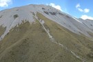
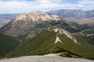
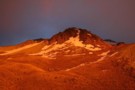
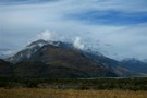
Helicopter Hill
Photograph
•
Distance: 442m away
From Lyndon Saddle, the climb to the small summit is quick and easy (1256m).
More ▶︎
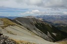
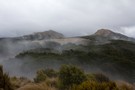
Camp Saddle / Lyndon Saddle spur
Photograph
•
Distance: 1.1km away
Scree slope leading down to Lyndon Saddle and Helicopter Hill. Over the highway is the yellow Broken Hill, with the ...
More ▶︎
Craigieburn Shelter campsite
Campsite
•
Basic Campsite (DOC). 20 spaces.
•
Distance: 1.2km away
Popular campsite on the banks of Cave Stream in Craigieburn Forest Park, with a number of easy walking tracks nearby. ...
More ▶︎
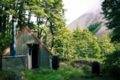
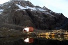
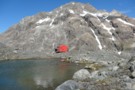
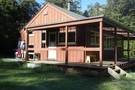
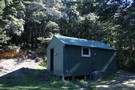
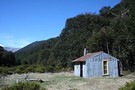
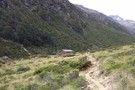
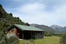
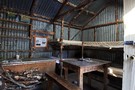
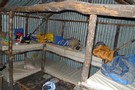
Cass Saddle Hut
Hut
•
Basic Hut/Bivvy (DOC). Capacity: 4.
•
Distance: 1.3km away
An old Forest Service hut on the Cass-Lagoon Saddle Track, built in 1953. The hut is located just below the ...
More ▶︎
Cass Saddle Hut
Photograph
•
Distance: 1.3km away
Cass Saddle Hut, when I arrived, then, the morning after...
More ▶︎
Camp Saddle / Lyndon Saddle circuit
GPX file
•
Distance: 1.7km away
A loop in Craigieburn Forest Park, leading up onto a spur of the Craigieburn Range.
This route leads up the Broken ...
More ▶︎
Mount Wall
GPX file
•
Distance: 2.3km away
A circuit from the Broken River locked gate up onto the Craigieburn Range, along to Mount Wall, and down. Points ...
More ▶︎
Camp Saddle / Lyndon Saddle spur
Photograph
•
Distance: 2.4km away
Once up on Camp Saddle, it's a straightforward ridge cruise following the arc to the left.
More ▶︎
Waimakariri to Rakaia
Video
•
Distance: 2.5km away
Video showing hike up the Waimakariri, over Jordan Pass, with a packraft down the Avoca and then walking up Rakaia ...
More ▶︎
Camp Saddle
Photograph
•
Distance: 2.6km away
The view south, down Camp Stream, Craigieburn Range.
More ▶︎
Old Basins Hut
Hut
•
Basic Hut/Bivvy (DOC). Capacity: 5.
•
Distance: 2.7km away
Old hut in the Avoca Valley at Basin Creek. Old Basins Hut is not the north bank, while Basins Hut ...
More ▶︎
Basins Hut
Hut
•
Standard Hut (DOC). Capacity: 6.
•
Distance: 2.8km away
Small hut on the Avoca River next to Basin Creek.
More ▶︎
Way out, Cass Lagoon Saddle
Photograph
•
Distance: 3.0km away
Hamilton Hut is so nice. Great view.Will be back!!
More ▶︎
Avoca Hut
Hut
•
Basic Hut/Bivvy (Canterbury University tramping Club). Capacity: 6.
•
Distance: 3.0km away
Small hut in the Avoca Valley.
Open to public, maintained by Canterbury University tramping Club (CUTC). Report any damage to CUTC ...
More ▶︎
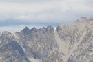
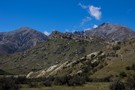
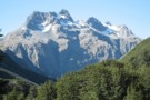
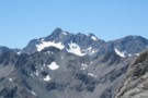
Mount Wall
Photograph
•
Distance: 3.5km away
1874m peak on the Craigieburn Range. The Broken River Ski Club occupies the valley to the right.
More ▶︎
Mount Wall, Craigieburn Range
Track
•
1 day. Medium/hard. Return by the same track.
•
Distance: 3.5km away
Day walk to a summit overlooking the Broken River Ski Area.
More ▶︎

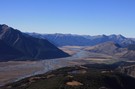
Arthur's Pass National Park
Place
•
National Park. 1145.00km2.
•
Distance: 3.7km away
This alpine park straddles the Main Divide of the Southern Alps, with dry beech forests in the east and damp ...
More ▶︎
Packrafting trip from Bealey to upper Rakaia River
Video
•
Distance: 4.1km away
A video of a hiking and packrafting trip up over Jordan saddle, down the Avoca, Harper, and Wilberforce Rivers, then ...
More ▶︎
Bealey Spur - Jordan Saddle - Waimakariri River
Track
•
1 – 2 days. Medium/hard. Loop track with a road section.
•
Distance: 4.1km away
A long day trip with great views from open tops travel, a descent down a stream and beginning and ending ...
More ▶︎
Barker Hut
Track
•
2 – 3 days. Medium. Return by the same track.
•
Distance: 4.4km away
Surrounded by glaciers at the head of the White River, this is the highest hut in Arthur's Pass National Park.
More ▶︎
View of Torlesse Gap from the west
Photograph
•
Distance: 4.4km away
The well recognised landmark on the Torlesse Range can easily be seen from the top of Broken Hill in the ...
More ▶︎
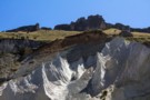
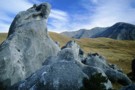
Castle Hill
Photograph
•
Distance: 4.5km away
not much of a tramp, but worth a look. Flock hill.
More ▶︎
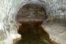
Cave Stream
Track
•
Medium. One way (about 5 mins walk from end to end).
•
Distance: 4.7km away
An exciting walk through a twisty limestone cave near Castle Hill.
More ▶︎
Barker Hut
Photograph
•
Distance: 5.0km away
The Barker Hut on an absolutely stunning April morning in 2011. Not a breath of wind, not a cloud in ...
More ▶︎
Looking down on Barker Hut
Photograph
•
Distance: 5.0km away
On a perfect autumn morning we picked our way up some of the ridges of shattered rock behind Barker Hut. ...
More ▶︎
Barker Hut
Hut
•
Serviced Alpine Hut (Canterbury Mountaineering Club). Capacity: 10.
•
Distance: 5.0km away
At 1560m, Neville Barker Memorial Hut is the highest in Arthur's Pass National Park, surrounded by the glaciers of the ...
More ▶︎
Barker Hut at sunrise.
Photograph
•
Distance: 5.1km away
Overcast March morning after a night of wind and sleet.
More ▶︎
Barker Hut
Photograph
•
Distance: 5.1km away
The Canterbury Mountaineering Club hut high at the head of the White River.
More ▶︎
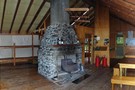
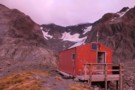
Hamilton Hut
Hut
•
Serviced Hut (DOC). Capacity: 20.
•
Distance: 5.1km away
A large hut on the Cass-Lagoon Saddle Track. The hut is well situated on a terrace above the wide Hamilton ...
More ▶︎
Hamilton Hut - Dec 2009
Photograph
•
Distance: 5.1km away
Exterior shot of Hamilton Hut in December 2009.
More ▶︎
Hamilton hut
Photograph
•
Distance: 5.1km away
Hamilton hut, 20 bunks and very cosy. Loads of sandflies but well equipped with nets on the doors to keep ...
More ▶︎
Anti Crow Hut
Hut
•
Standard Hut (DOC). Capacity: 6.
•
Distance: 5.4km away
In the Waimakariri valley near Anti Crow River.
The previous Anti Crow Hut used to be the CMC hut about half ...
More ▶︎
White River
Photograph
•
Distance: 5.6km away
Barker Hut sits on the rocky outcrop at centre.
More ▶︎
Hogs Back Circuit
Track
•
Easy. Loop track.
•
Distance: 5.8km away
Great views of the Cass basin and surrounding mountain ranges.
More ▶︎
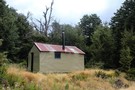
Weka Burnet biv
Hut
•
Basic Hut/Bivvy (DOC). Capacity: 2.
•
Distance: 5.8km away
2 person upright biv as opposed to the dogbox style at junction of Weka and Burnet Streams, not far from ...
More ▶︎
Hogs Back Circuit
Photograph
•
Distance: 5.8km away
A variation of the Hogsback mountain bike track. The mtb track is roughly marked as s-d-c-t. The walking circuit is ...
More ▶︎
Complete and Final Version of Craigieburn Double Crossing
Article
•
Distance: 5.8km away
Double crossing of the Craigieburn Range from Hogs Back MTB trail over to Hamilton Hut, then return via Mt Cheeseman ...
More ▶︎
Double Crossing of Craigieburn Range
Photograph
•
Distance: 5.8km away
Queens Birthday weekend trip, combined with scenic tour down the Harper to Mystery Tarn, on the Clay Range.
More ▶︎
Bealey Hut
Hut
•
Basic Hut/Bivvy (DOC). Capacity: 6.
•
Distance: 6.1km away
A tidy hut near the end of the Cass-Lagoon Saddle Track. The hut has six bunks (most, but not all, ...
More ▶︎
Bealey Hut
Photograph
•
Distance: 6.1km away
A tidy little hut at the Cora Lynn end of the Cass-Lagoon Saddle Track.
More ▶︎
East Hawdon Stream
Track
•
1 – 2 days. Easy/medium. Return via same track.
•
Distance: 6.1km away
A short walk to a new biv located on a branch of the Hawdon River.
More ▶︎
Hawdon Shelter
Hut
•
Shelter (DOC).
•
Distance: 6.1km away
An open shelter at the edge of extensive frost flats. Ample camping opportunities.
More ▶︎
Bealy hut
Photograph
•
Distance: 6.2km away
Arthurs Pass end of the Lagoon Saddle track 5 minutes from the Cora Lynn carpark.
More ▶︎

Edwards River-Hawdon River
Track
•
3 days. Medium. One way.
•
Distance: 6.2km away
See Hawdon River.
More ▶︎
Hawdon Shelter campsite
Campsite
•
Informal campsite (DOC). 20 spaces.
•
Distance: 6.2km away
Broad golden grass flats on the banks of the Hawdon River. Kea overhead and ample space to avoid the crowds. ...
More ▶︎
Hawdon River flats
Photograph
•
Distance: 6.3km away
Ample camping space around the Hawdon Shelter across the Mount White Bridge. The Pyramid (1608m) is in the background.
More ▶︎
Broken River Hut via Cave Stream
GPX file
•
Distance: 6.3km away
Alternative route to Broken River Hut. Land owners' permission needed.
More ▶︎
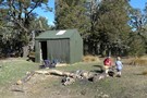
Back Basins Hide
Hut
•
Basic Hut/Bivvy (DOC). Capacity: 2.
•
Distance: 6.3km away
Small biv on the bushline on the Tobacco Range above Basin Creek.
More ▶︎
Horrible and Misery
Photograph
•
Distance: 6.4km away
Mounts Horrible (1234m) and Mount Misery (1765m) from the Hawdon River flats.
More ▶︎
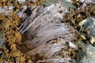
Kammeis, Ice needles
Photograph
•
Distance: 6.4km away
These are ice needles that form under little stones and pieces of dirt and lift them up perpendicular to the ...
More ▶︎
Prebble Hill (902m)
Photograph
•
Distance: 6.7km away
Red Peak (1853m), The Gap, and Castle Hill Peak (1998m) behind.
More ▶︎
West Harper Hut
Photograph
•
Distance: 6.8km away
Historic hut on the Cass-Lagoon Saddle Track.
More ▶︎
West Harper Hut
Hut
•
Basic Hut/Bivvy (DOC). Capacity: 5.
•
Distance: 6.8km away
An historic hut on the Harper River with axe-cut beams, canvas bunks and a dirt floor. Although basic, this hut ...
More ▶︎
Edwards River-Otehake River
Track
•
4 days. Medium. One way.
•
Distance: 6.9km away
Another north-south crossing of the park.
More ▶︎
Towards Andrews and Binser
Photograph
•
Distance: 6.9km away
Taken end of Summer '06 on a brief jaunt between Hawdon and Andrews stream, nearby is a grove of gooseberries ...
More ▶︎
Otehake Hut
Hut
•
Standard Hut (DOC).
•
Distance: 6.9km away
Otehake Hut. NZFS six bunker with porch. Built 1962/63.
More ▶︎
Urquhart's Hut
Hut
•
Basic Hut/Bivvy (DOC). Capacity: 6.
•
Distance: 7.1km away
Historic hut build in 1933 during the Great Depression. Situated on a terrace in the Wilberforce Valley. Dirt floor and ...
More ▶︎
Bealey Spur
Track
•
1 – 2 days. Easy/medium. One way.
•
Distance: 7.1km away
Gentle climb with generous views over Arthurs Pass and the Waimakariri River. The track visits an historic musterers' hut framed ...
More ▶︎
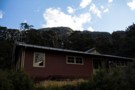
Bealey Spur Hut
Photograph
•
Distance: 7.1km away
Hut is located bottom centre of picture, in the clearing.
More ▶︎
4 day circuit in Arthurs Pass - White Col, Weka Burnet, Bristed Stream, Jordan Saddle
Article
•
Distance: 7.2km away
1st day: Barker Hut, 2nd day: Weka Burnet Biv via White Col and Burnet Stream, 3rd day: Bristed Stream to ...
More ▶︎
Bealey Spur shortcut
GPX file
•
Distance: 7.2km away
A side track that bypasses Cloudesley Road.
More ▶︎
Hog's Back Track
Track
•
Easy. Return by the same track.
•
Distance: 7.3km away
https://www.craigieburntrails.org.nz/tracks/hogs-back-track/
More ▶︎
Circuit of Broad Stream, Harper Saddle, Lagoon Saddle, Mangos Creek, Broad Stream
Article
•
Distance: 7.5km away
A 2 day circuit in Craigieburn Forest Park, crossing 2 low saddles above the bushline and travelling in easy, pleasant ...
More ▶︎
Harman Pass - Taipo River - Kelly Saddle
Track
•
3 – 5 days. Medium/hard. One way.
•
Distance: 7.8km away
A long journey through the west of Arthur's Pass National Park.
More ▶︎
Carrington Hut
Hut
•
Serviced Hut (DOC). Capacity: 36.
•
Distance: 7.8km away
A large hut in the upper Waimakariri River, and often the first or last hut on a longer trip.
The extensive ...
More ▶︎
Other Part of trail to Carrington Hut
Photograph
•
Distance: 7.8km away
the trail after a nice rain
More ▶︎
Carrington Hut
Photograph
•
Distance: 7.9km away
A large wooden hut at the confluence of the Waimakariri and the White Rivers.
More ▶︎
Andrews Shelter campsite
Campsite
•
Informal campsite (DOC). 20 spaces.
•
Distance: 7.9km away
Free camping on flats next to Andrews Stream. A sturdy shelter is located here. From here, the Andrews Valley Track ...
More ▶︎
Carrington Peak
Photograph
•
Distance: 7.9km away
Carrington Peak, Arthur's Pass, from near Carrington hut. taken February 2007
More ▶︎
Casey Saddle - Poulter River - Binser Saddle
Track
•
2 – 3 days. Easy/medium. Loop track with a short road section.
•
Distance: 8.0km away
A brief circuit crossing one open saddle and one bush saddle in the southeastern corner of Arthur's Pass National Park. ...
More ▶︎
Andrews Shelter
Photograph
•
Distance: 8.0km away
An enclosed shelter at the beginning of the Andrews Track leading to Casey Saddle.
More ▶︎
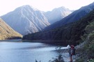
Lake Minchin
Photograph
•
Distance: 8.0km away
Not far from the new Poulter Hut, though the old Trust Poulter Hut has more 'character' and is quite liveable. ...
More ▶︎
Andrews Stream-Lake Minchin-Townsend Creek
Track
•
4 days. Medium. One way.
•
Distance: 8.0km away
A north-south crossing of the park.
More ▶︎
Andrews Shelter
Hut
•
Shelter (DOC).
•
Distance: 8.0km away
Shelter and campsite on Andrews Stream near the Mount White Bridge. Water is available from the nearby stream. Here, or ...
More ▶︎
Penny Pass
Track
•
3 – 4 days. Medium. Loop track.
•
Distance: 8.0km away
3 day trip from upper Poulter River over Penny Pass between Minchin and Thompson Streams.
More ▶︎
Lagoon Saddle Hut
Photograph
•
Distance: 8.2km away
When you stop off at the Lagoon Saddle Shelter, this shiny hut glints through the trees from across the creek.
More ▶︎
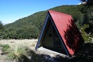
Lagoon Saddle Hut
Hut
•
Basic Hut/Bivvy (DOC). Capacity: 2.
•
Distance: 8.2km away
A shiny corrugated iron hut across the creek from the shelter near Lagoon Saddle. The hut is tidy, features shelving ...
More ▶︎
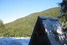
Lagoon Saddle Shelter
Photograph
•
Distance: 8.2km away
A small A frame day shelter near Lagoon Saddle.
More ▶︎
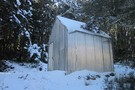
Lagoon Saddle hut in the Snow
Photograph
•
Distance: 8.2km away
Lagoon Saddle hut on a snowy winters day
More ▶︎
Park Morpeth Hut
Hut
•
Standard Hut (DOC). Capacity: 6.
•
Distance: 8.6km away
This is a Canterbury Mountaineering Club Hut, and it appears in DOC's hut list. On the classic Three Passes route.
More ▶︎
Lagoon Saddle Shelter
Hut
•
Basic Hut/Bivvy (DOC).
•
Distance: 8.7km away
An A-frame day shelter located in a sunny clearing near Lagoon Saddle on the Cass-Lagoon Saddle Track. The Lagoon Saddle ...
More ▶︎
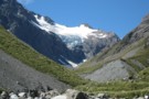
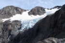
Cronin Glacier
Photograph
•
Distance: 8.9km away
Cronin valley and glacier on the 3 passes route. taken in perfect weather, February 2007.
More ▶︎
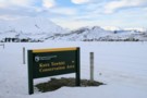
DOC sign
Photograph
•
Distance: 8.9km away
Kura Tawhiti Conservation Area is the karst landscape also known as Castle Hill, located on the road between Porter's and ...
More ▶︎
Bealey Spur Hut
Hut
•
Basic Hut/Bivvy (DOC). Capacity: 6.
•
Distance: 9.0km away
Historic 1925 musterers' hut on an easy grassy spur over the Waimakariri River.
Old basic hut built around 1925 by musterers ...
More ▶︎
Bealey Spur Hut - Oct 2011
Photograph
•
Distance: 9.0km away
Exterior shot of the Bealey Spur Hut in October 2011.
More ▶︎
bealey spur hut interior
Photograph
•
Distance: 9.0km away
a beech pole frame with 1930's corrugated iron, viewed from the door
More ▶︎
Mt Bealey
Photograph
•
Distance: 9.0km away
Its my first walk. up Mt Bealey. Absolutly love being in the nature, So happy, So excited. My friend described ...
More ▶︎
Bealey Spur Hut - Interior
Photograph
•
Distance: 9.0km away
Inside the bealey spur hut, facing the bunk beds
More ▶︎
Bealey Spur Hut - Oct 2011
Photograph
•
Distance: 9.0km away
Shot of the interior of the Bealey Spur Hut in October 2011.
More ▶︎
Cronin Icefall
Photograph
•
Distance: 9.3km away
Seen from Whitehorn Pass, the spectacular icefall coming off the Cronin Glacier. Whitehorn Pass is the highest point on the ...
More ▶︎
Three Passes
Track
•
4 – 5 days. Medium/hard. One way.
•
Distance: 9.3km away
A classic trip from Arthur's Pass across Browning, Whitehorn and Harman Passes, emerging near Lake Kaniere on the West Coast.
More ▶︎
snow ghost
Photograph
•
Distance: 9.3km away
snow ghost, taken from Whitehorn pass Feb 2007.
More ▶︎
Striking limestone formations of Castle Hill
Photograph
•
Distance: 9.4km away
Known as Kura Tawhiti to Ngāi Tahu, this is an area of historic significance, with rock drawings hidden amongst the ...
More ▶︎
Woolshed Hill
Track
•
Medium. Hawdon Valley.
•
Distance: 9.4km away
The track begins steeply climbing through beech forest from near the Hawdon carpark. It emerges into brilliant dracophyllum draped tops ...
More ▶︎
Sudden valley track
Article
•
Distance: 9.5km away
Comments to add to other articles about Sudden Valley
More ▶︎
Sudden Valley
Article
•
Distance: 9.5km away
Sudden Valley off Hawdon Valley - Arthurs Pass
Great short trip in times of low rainfall
More ▶︎
Red beech forest
Photograph
•
Distance: 9.7km away
Red beech occupies some of the flat terrace above Andrews Stream, Andrews Track, Arthur's Pass National Park.
More ▶︎
Ascending Whitehorn Snowfield
Photograph
•
Distance: 9.7km away
Only old icy snow on the field in summer. Ice axe recommended for this part, but if confident on ice ...
More ▶︎
Misty morning on Bealey Spur
Photograph
•
Distance: 9.8km away
Early morning drizzle releases its grip.
More ▶︎
Sudden Valley Biv
Hut
•
Basic Hut/Bivvy (DOC). Capacity: 2.
•
Distance: 9.9km away
The small dark biv was replaced Summer 2008. Camping is possible around the biv.
More ▶︎
Sudden Valley
Track
•
2 days. Medium. Return via same track.
•
Distance: 9.9km away
A secluded hanging valley in the southeast corner of Arthur's Pass National Park
More ▶︎
"New" Sudden Valley biv Feb 2010
Photograph
•
Distance: 9.9km away
Replacement for old biv. This biv is only a short distance from the Hawdon Shelter. You can get in and ...
More ▶︎
Mt Bealey - Lyell Peak - Avalanche Peak Traverse
Track
•
1 day. Medium. Loop track.
•
Distance: 9.9km away
A classic traverse from Mt Bealey to Avalanche Peak
More ▶︎
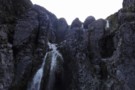
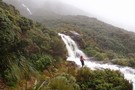
Taipoiti Gorge
Photograph
•
Distance: 10.0km away
Described in DoC literature as "impassable", small waterfalls at the top of the Taipoiti Stream, on the way from Carrington ...
More ▶︎