Nearby
Fiordland National Park
Glaisnock Wilderness Area
Place
•
Wilderness Area. 1250.00km2.
•
Distance: less than 100m away
A remote block of Fiordland forest stretching from the Tasman Sea to Lake Te Anau. The area borders George, Sutherland, ...
More ▶︎
Te Wāhipounamu - South West New Zealand World Heritage Area
Place
•
World Heritage Area. 26000.00km2.
•
Distance: 2.8km away
This UNESCO World Heritage Area occupies the southwestern corner of New Zealand. It includes four national parks, and covers 10% ...
More ▶︎
Worsley Rock Biv
Rock bivouac
•
Distance: 3.4km away
Large flat dry rock biv in the northern head of the Wild Natives, 10-15 minutes from the Wosley Pass. A ...
More ▶︎
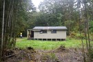
Lake Hankinson Hut
Hut
•
Standard Hut (DOC). Capacity: 12.
•
Distance: 3.6km away
Hut at the head of Lake Hankinson on the George Sound Track.
More ▶︎
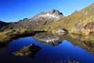
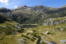
Alpine Tarn
Photograph
•
Distance: 4.3km away
Alpine Tarn, ridge nth of Tutu Burn, Fiordland NP
More ▶︎
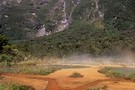
The Grebe Valley
Photograph
•
Distance: 4.3km away
Looking south, up the the Grebe valley from the Borland Road, opposite the entrance to the Florence Stream.
More ▶︎
Freeman Burn Hut
Hut
•
Standard Hut (DOC). Capacity: 10.
•
Distance: 4.5km away
A hut at the head of North Arm, Lake Manapouri, accessible by boat.
During the 1920s, Les Murrell ran the Doubtful ...
More ▶︎
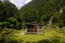
Thomson Hut
Hut
•
Standard Hut (DOC).
•
Distance: 4.9km away
(Lake) Thomson Hut - on the George Sound track at the forks with the Wapiti Creek.
Wood burner, tank water, creek ...
More ▶︎
Worsley Hut
Hut
•
Standard Hut (DOC). Capacity: 12.
•
Distance: 6.0km away
12 bunk (DOC say 20 but there's only 12 mattresses and 12 places for them) hut at the mouth of ...
More ▶︎
Robin Saddle Hut
Hut
•
Basic Hut/Bivvy (DOC). Capacity: 4.
•
Distance: 6.1km away
4 bunk hut in the Murchinson Mountains (but outside the Takehe special protected area)
More ▶︎
Glaisnock Hut
Hut
•
Standard Hut (DOC). Capacity: 12.
•
Distance: 6.4km away
Hut at the head of North Fiord, Lake Te Anau.
More ▶︎
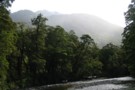
Iris Burn
Photograph
•
Distance: 6.7km away
This is just down from the waterfall, and basically the first time you see the river, as it descends into ...
More ▶︎
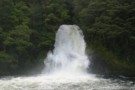
Iris Burn Waterfall
Photograph
•
Distance: 6.7km away
About 15 minutes walk from Iris Burn Hut... and WELL worth it! Spectacular, especially when it has just been snowing ...
More ▶︎
Iris Burn Hut
Hut
•
Great Walks Hut (DOC). Capacity: 60.Bookings required.
•
Distance: 6.8km away
Tucked between lakes Manapouri and Te Anau, this Great Walks hut is part of the Kepler Track. Bookings required during ...
More ▶︎
Junction Burn Hut
Hut
•
Standard Hut (DOC). Capacity: 12.
•
Distance: 7.7km away
Hut on the shore of South West Arm, Lake Te Anau.
More ▶︎
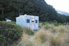
Borland Shelter / Borland Bivvy / Island Lake Track Shelter
Hut
•
Basic Hut/Bivvy (DOC). Capacity: 3.
•
Distance: 7.8km away
The Borland Shelter (sleeps 3, river water) is a basic road-end A-frame shelter. The hut has no facilities apart from ...
More ▶︎

The track is booked out? Try TrekWatch.net
Article
•
Distance: 8.8km away
SMS texts directly to your cellphone when a place becomes available. Free of charge!
More ▶︎
North Borland Hut
Hut
•
Basic Hut/Bivvy (DOC). Capacity: 2.
•
Distance: 9.4km away
Small corrugated iron hut on the north branch of the Borland Burn.
More ▶︎
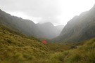
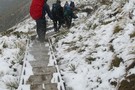
Hanging Valley Shelter September 18, 2011
Photograph
•
Distance: 9.5km away
Kinda difficult to use the shelter. Good access to the loo though
More ▶︎