Nearby
Lake Emma to Lake Camp
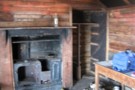
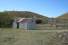
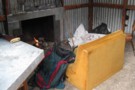
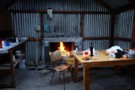
Lake Emma hut
Hut
•
Shelter (DOC).
•
Distance: less than 100m away
An historic corrugated iron hut on the shoreline of Lake Emma. The hut is thought to date from the 1880s, ...
More ▶︎
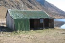
Lake Emma Hut
Photograph
•
Distance: 112m away
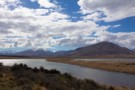
Lake Emma Hut with the Clent Hills and Mount Taylor (2330m) beyond.
More ▶︎
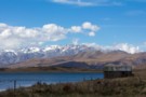
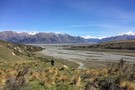
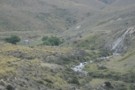
Lake Emma and hut
Photograph
•
Distance: 401m away
Tucked into the flanks of Mount Harper, Lake Emma Hut sits on the shore of the lake. The historic farm ...
More ▶︎
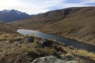
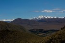
Lake Emma
Photograph
•
Distance: 559m away
Mount Potts (2194m) and Mount Guy beyond (1322m).
More ▶︎
Mount Guy
Photograph
•
Distance: 1.4km away
This small hill at the foot of Lake Clearwater offers grand views of the mountains to the north and west.
More ▶︎
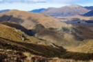
Mount Guy
Track
•
1 day. Medium. Loop track.
•
Distance: 1.5km away
This loop takes in a little mountain and expansive views over Lake Clearwater and the Hakatere Basin.
More ▶︎

Te Araroa Trail
Track
•
95 days. Medium. One way.
•
Distance: 1.5km away
Te Araroa is a walking trail running the entire length of the North and South Islands. The trail opened 3 ...
More ▶︎
Lake Clearwater village to Mount Guy turn off
Section
•
Distance: 1.5km away
Follow the Lake Clearwater Circuit Track on a 4WD road by the eastern margin of the lake.
More ▶︎
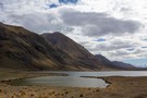
Lake Clearwater Reserve
Campsite
•
Basic Campsite (Not applicable).
•
Distance: 1.7km away
Campsite and day use area on the banks of Lake Clearwater. There are a number of interesting walks in the ...
More ▶︎
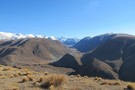
D'Archiac and the Havelock River
Photograph
•
Distance: 2.7km away
Mount D'Archiac (2875m) is 43km away. It lies at the end of the Sibbald Range, just south of the Main ...
More ▶︎
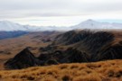
View from Mount Guy
Photograph
•
Distance: 3.3km away
To the left is point 2098 on the Big Hill Range, and the plateau of the Dogs Range.
To the ...
More ▶︎
Mount Potts
Photograph
•
Distance: 3.4km away
Mount Potts (2184m) with the Potts River in the foreground. Viewed from Mount Guy.
More ▶︎
Hakatere Conservation Park
Place
•
Conservation Park. 600.00km2.
•
Distance: 3.5km away
This park protects high country between the Rakaia and Rangitata Rivers in the Ashburton Lakes District, Mid-Canterbury.
More ▶︎
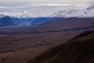
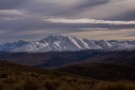
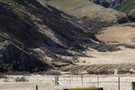
Moraines below the Dogs Range
Photograph
•
Distance: 3.7km away
Moraines on the glacial till plain that drops from the plateau of the Dogs Range at right. Mystery Lake is ...
More ▶︎
Mt Guy from the Dogs Range
Photograph
•
Distance: 6.6km away
Here's a photo from the dogs range , In the fore front are rock drumlins ( I think ) and ...
More ▶︎
Dog Hill to Boundary Creek Hut
Photograph
•
Distance: 8.3km away
From Buicks bridge car park their is a 4WD track (4.24km ) running to the bace of dog hill , ...
More ▶︎
Barrosa
GPX file
•
Distance: 8.6km away
Poled route to the summit of Mount Barrosa, in the Clent Hills.
More ▶︎
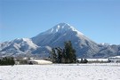
Mt Barrosa
Track
•
1 day. Medium. Return by the same track.
•
Distance: 8.6km away
A volcanic summit (1364m) in the Clent Hills with sweeping views across the Ashburton Lakes basin.
More ▶︎
Mystery Lake Track
Track
•
1 – 2 days. Easy. Loop track.
•
Distance: 9.1km away
Circuit track to a small tarn in the Ashburton Lakes.
More ▶︎
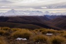
Ashburton Lakes
Photograph
•
Distance: 9.8km away
The view west from Mount Barrosa. Mount Guy (1319m) is in the foreground, with the sharp summit of distant Mt ...
More ▶︎
boundary creek hut
Photograph
•
Distance: 9.8km away
boundary creek hut in the distance walking up from the gorge
More ▶︎
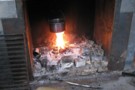
boundary creek hut
Photograph
•
Distance: 9.8km away
everyone likes a hot wash in the morning and with river water so close and a fire and billy why ...
More ▶︎
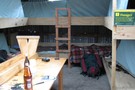
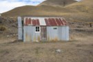
Boundary Creek Hut (Hakatere)
Hut
•
Basic Hut/Bivvy (DOC). Capacity: 8.
•
Distance: 9.8km away
boundary creek hut has 8 bunks and a concrete floor, mattresses and open fire and its very own resident mice ...
More ▶︎
Boundary Creek Hut
Photograph
•
Distance: 9.8km away
A great little musterers hut in the Hakatere Conservation Park near the South Branch Asburton River.
More ▶︎