Nearby
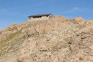
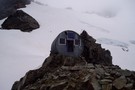
Empress Hut
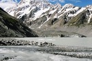
Aoraki / Mount Cook National Park
Place
•
National Park. 706.96km2.
•
Distance: 1.7km away
A climbers' park surrounding New Zealand's highest peak, Aoraki / Mount Cook, at 3724m. Mount Cook National Park is part ...
More ▶︎
Plateau Hut
Hut
•
Serviced Alpine Hut (DOC). Capacity: 33.
•
Distance: 5.2km away
Alpine hut on the Grand Plateau beneath Aoraki / Mount Cook.
More ▶︎
Caroline Hut
Hut
•
Private hut (Private).
•
Distance: 5.4km away
Private, locked hut on the Ball Ridge. This hut is used by guided parties on the Ball Pass route.
For ...
More ▶︎
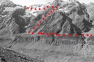
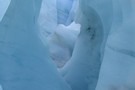
Ball pass route 1996
Photograph
•
Distance: 6.1km away
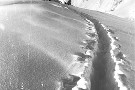
The route over Ball Pass looking across the Hooker Glacier.
May have changed somewhat considering the date taken.
More ▶︎
Ball Pass
Track
•
2 – 3 days. Hard. One way.
•
Distance: 6.1km away
A challenging crossing of the Kirikirikatata / Mount Cook Range between the Hooker and Tasman Glaciers just 5km south of ...
More ▶︎
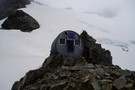
Haast Hut
Hut
•
Standard Hut (DOC). Capacity: 4.
•
Distance: 6.3km away
Climbers' hut located on the Haast Ridge, below Plateau Hut and the Grand Plateau.
More ▶︎
Ball Hut
Hut
•
Standard Hut (DOC). Capacity: 3.
•
Distance: 6.7km away
Small Hut on the moraine next to the Tasman Glacier, just south of the Ball Glacier.
The first hut was ...
More ▶︎
![Ball Shelter [Removed 2009]](http://tramper.nz/imgcache/1/1108-mini.jpg)
Ball Shelter [Removed 2009]
Hut
•
Removed!
•
Distance: 6.7km away
Perched on the edge of the Tasman Glacier moraine wall. Although this hut is only about 5km from the summit ...
More ▶︎
Ball Shelter
Track
•
1 – 2 days. Easy/medium. Return via same track.
•
Distance: 6.7km away
Follow the old Ball Hut Road from the Blue Lakes car park along the moraine wall of the Tasman Glacier ...
More ▶︎
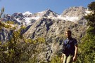
Copland valley, Mt Sefton
Photograph
•
Distance: 6.7km away
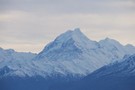
mt sefton summit from the valley floor
More ▶︎
Copland Shelter
Hut
•
Shelter (DOC). Capacity: 4.
•
Distance: 7.0km away
Copland Emergency Shelter on the east side of the Copeland Pass. This is serious country and should only be undertaken ...
More ▶︎
Copland Track
Track
•
3 days. Hard. One way.
•
Distance: 7.0km away
Classic mountaineering route between Mount Cook and the West Coast. See Welcome Flat.
More ▶︎
Hooker Hut
Hut
•
Standard Hut (DOC). Capacity: 12.
•
Distance: 7.4km away
Historic hut built in 1909/10 and situated near the moraine wall of the Hooker Glacier. It has been shifted twice ...
More ▶︎
Hooker glacier and Hooker Hut
Photograph
•
Distance: 7.5km away
On the west side of Ball Pass it is easy to view the Hooker hut and the beginning of the ...
More ▶︎
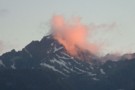
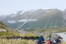
Mt Copland through rose coloured clouds
Photograph
•
Distance: 7.6km away
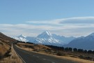
Like many people we went to the lookout near Fox Glacier village to watch the sun set over Mt Cook ...
More ▶︎
Pioneer Hut
Hut
•
Serviced Alpine Hut (NZAC). Capacity: 16.
•
Distance: 8.7km away
New Zealand Alpine Club hut perched on the rocky Pioneer Ridge over the Fox Glacier névé. The Pioneer Hut looks ...
More ▶︎
New Years on the glaciers -2003
Article
•
Distance: 8.7km away
Part of a four day traverse of Fox and Franz Josef glaciers starting at Pioneer hut on Fox and making ...
More ▶︎
Chancellor Hut
Hut
•
Serviced Alpine Hut (DOC). Capacity: 12.
•
Distance: 9.5km away
This historic hut is located 200m above Fox Glacier on Chancellor Ridge. The bunk room was formally the women's room. ...
More ▶︎
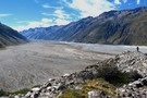
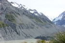
Murchison valley from Tasman moraine
Photograph
•
Distance: 9.5km away
This picture was taken from the eastern Tasman moraine where the Murchison glacier once met the Tasman glacier.
The size is ...
More ▶︎
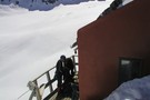
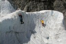
Sitting above the Hooker Glacier enroute from Ball Pass
Photograph
•
Distance: 9.9km away
Looking southward toward MtCook Village you've got a clear view of the route leading up to Mueller Hut
More ▶︎
Cloudmaker
Photograph
•
Distance: 9.9km away
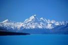
Mount Cook (Aoraki) forms a large cloud, seen from the Hooker Lake.
More ▶︎