Related
Adams Wilderness Area
Place.
Wilderness Area. 465.87km2.
Created
11 February 201411 February 2014.
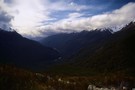
This wilderness area includes the Adams and Wilberg Ranges behind Harihari, through to the Butler Range east of the Main Divide. The area is bounded by the Perth River in the south and the Wanganui River in the north.
More ▶︎
Glaisnock Wilderness Area
Place.
Wilderness Area. 1250.00km2.
Updated
6 July 20186 July 2018.
A remote block of Fiordland forest stretching from the Tasman Sea to Lake Te Anau. The area borders George, Sutherland, and Bligh Sounds in the northwest, and Worsley Arm, North and Middle Fiords in the southeast. The George Sound Track ...
More ▶︎
Fiordland National Park
Place.
National Park. 12570.00km2.
Updated
20 November 201220 November 2012.
New Zealand's largest park, with large areas of impenetrable wilderness. Includes the Glaisnock and Pembroke Wilderness Areas. Fiordland National Park is part of Te Wahipounamu World Heritage Area. Highest point: 2746m (Mt Tutoko).
More ▶︎

Great Walks Information
The DOC Great Walks are a set of premium tramping tracks throughout New Zealand.
More ▶︎
Olivine Wilderness Area
Place.
Wilderness Area. 830.00km2.
Created
10 February 201410 February 2014.
Remote country in the Olivine Range. The wilderness area includes the Red Hills, the Olivine Ice Plateau, and the Joe River. It borders Mount Aspiring (3027m) and includes Stargazer (2341m) and Moonraker (2027m).
More ▶︎
Aoraki / Mount Cook National Park
Place.
National Park. 706.96km2.
Updated
25 February 201425 February 2014.
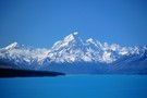
A climbers' park surrounding New Zealand's highest peak, Aoraki / Mount Cook, at 3724m. Mount Cook National Park is part of Te Wahipounamu World Heritage Area. The Copland Track is a classic crossing of Copland Pass (2150m), leading from Mount ...
More ▶︎

Mount Aspiring National Park
Place.
National Park. 3555.18km2.
Updated
24 September 201124 September 2011.
The third-largest national park, although most of its space is under-utilised. The Routeburn is the second busiest trail in New Zealand. The Olivine Wilderness Area is located in this park. Mount Aspiring National Park is part of Te Wahipounamu World ...
More ▶︎
Hooker Landsborough Wilderness Area
Place.
Wilderness Area. 410.00km2.
Created
10 February 201410 February 2014.
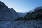
Remote peaks and valleys around Mount Hooker (2652m) and the head of the Landsborough River. The area borders Westland National Park in the north.
More ▶︎
Get into Hot Water this Winter!
I've compiled a checklist of hot springs to tempt you into the outdoors this winter.
More ▶︎
Pembroke Wilderness Area
Place.
Wilderness Area. 180.00km2.
Updated
6 July 20186 July 2018.
Wilderness area on the northern shoreline of Milford Sound within Fiordland National Park, including Mount Pembroke and the western slopes of the Darran Mountains.
More ▶︎
Westland / Tai Poutini National Park
Place.
National Park. 1316.00km2.
Updated
25 February 201425 February 2014.
This park stretches from the coastline along the Tasman Sea to the peaks of the Southern Alps. Westland National Park is part of Te Wahipounamu World Heritage Area.
More ▶︎
Hiking the Routeburn Track
The Routeburn Track is in the lower South Island of New Zealand and links 2 large National Parks - Mt. Aspiring and Fiordland - via the Harris Saddle (1,277 metres high). Glorious alpine scenery awaits you on this track along ...
More ▶︎