Nearby
Molesworth Recreation Reserve
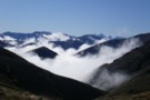
East West Route
Track
•
5 – 6 days. Medium. One way.
•
Distance: less than 100m away
A long trail through remote, desolate high country between the Clarence River and Molesworth Recreation Reserve.
More ▶︎
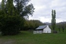
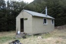
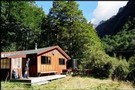
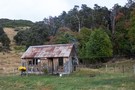
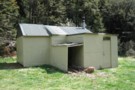
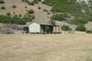
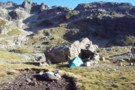
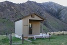
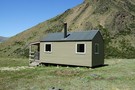
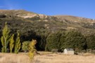
Molesworth Cob Cottage
Photograph
•
Distance: 1.5km away
Historic homestead and campsite at the original Molesworth site.
More ▶︎
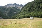
Molesworth Cob Cottage campsite
Campsite
•
Basic Campsite (DOC). 20 spaces.
•
Distance: 1.6km away
Campsite in Molesworth Recreation Reserve next to the original Molesworth Station homestead (1885).
More ▶︎
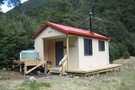
Top Gordon Hut
Hut
•
Standard Hut (DOC). Capacity: 6.
•
Distance: 1.8km away
Small hut in beech forest at high on Gordon Stream, beneath Saxton Saddle.
More ▶︎
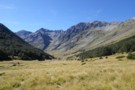
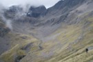
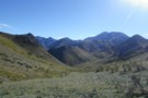
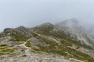
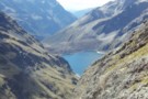
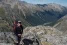
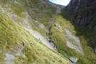
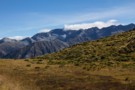
Wairau-Paske saddle
Photograph
•
Distance: 2.3km away
The saddle at the head of the Wairau, crossing into the Paske. Tiring climbing on loose scree, but a non-technical ...
More ▶︎
Top Leatham Hut
Hut
•
Standard Hut (DOC). Capacity: 6.
•
Distance: 2.8km away
Hut in beech forest high on Leatham River, Leatham Conservation Area.
More ▶︎
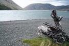
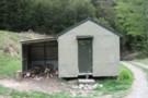
Horse Flat Hut
Hut
•
Shelter (DOC).
•
Distance: 2.9km away
An historic iron rabbiters' hut on river flats in the Clarence Reserve. The carved door indicates the hut was built ...
More ▶︎
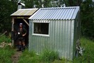
Branch Bivvy
Hut
•
Basic Hut/Bivvy (DOC). Capacity: 2.
•
Distance: 3.4km away
Small hut high on the Branch River, beneath the Raglan Range in the Leatham Conservation Area.
More ▶︎
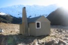
Paske Hut
Hut
•
Standard Hut (DOC). Capacity: 6.
•
Distance: 3.5km away
Hut in the headwaters of Paske Creek, beneath the St Arnaud Range. Passes beyond the hut lead into the head ...
More ▶︎
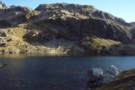
Paske Hut
Photograph
•
Distance: 3.6km away
Paske Hut and the towering walls of the head basin beyond. The two valley cutting left lead to the Paske-Clarence ...
More ▶︎
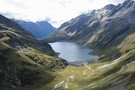
Waiau - Clarence Pass Lake Tennyson Circuit
Track
•
4 – 5 days. Medium/hard. Loop track.
•
Distance: 3.7km away
A challenging 4-5 day circuit in the St. James Conservation Area / Nelson Lakes National Park featuring two alpine pass ...
More ▶︎
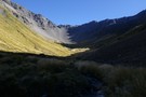
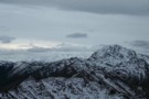
Clarence Pass
Photograph
•
Distance: 4.1km away
Climbing towards Clarence Pass from the East Branch of the Sabine River.
More ▶︎
Circuit of Saxton, Gordon, Waihopai , Acheron, and Port Cooper Saddles and Saxton
Article
•
Distance: 4.3km away
5 day circuit involving alternatives to the usual Saxton/Severn circuit. This avoids interminable plodding through wilding pines.
More ▶︎
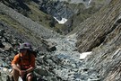
Elliott Bivvy Dec 2013
Photograph
•
Distance: 4.9km away
This newish bivvy is at the site of an older demolished hut. It is on the East - West route ...
More ▶︎
Elliott Bivvy
Hut
•
Basic Hut/Bivvy (DOC). Capacity: 2.
•
Distance: 4.9km away
This newish bivvy is at the site of an older demolished hut. It is on the East - West route ...
More ▶︎
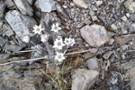
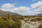
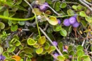
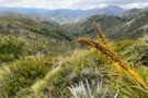
Edelweiss on Port Cooper Saddle
Photograph
•
Distance: 5.1km away
Pretty colours of rock compliment this plant.
More ▶︎
Edwards River Track
GPX file
•
Distance: 5.1km away
Tophouse Road to Scotties Camp Hut, in the St James Conservation Area.
More ▶︎
Edwards River, Lake Guyon, Fowler Pass circuit
Track
•
3 days. Easy/medium. Loop track with a road section.
•
Distance: 5.1km away
This circuit explores the southern portion of the St James Cycle Trail, explores the historic farm country around Lake Guyon ...
More ▶︎
Section: Edwards River - McArthur Track
Track
•
2 days. Easy/medium. One way.
•
Distance: 5.1km away
The southernmost section of the St James Cycle Trail, between Tophouse Road and the Lake Guyon junction on the Waiau ...
More ▶︎
Mt Dumblane
Track
•
1 day. Easy/medium. Return by the same track.
•
Distance: 5.4km away
An alternative to the more popular Mt Isobel at Hanmer Springs, this track is an easy climb with a reward ...
More ▶︎
Hanmer Forest Conservation Park
Place
•
Conservation Park. 130.00km2.
•
Distance: 5.4km away
This park surrounding Hanmer Springs is popular with families, offering easy walking and biking through both exotic and indigenous forests.
More ▶︎
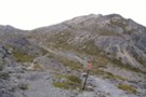
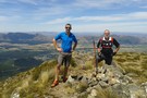
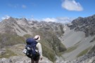
Mount Isobel
Photograph
•
Distance: 5.6km away
Poled route leading to the summit of Mount Isobel (1319m).
More ▶︎
Mount Isobel
Track
•
Easy/medium. Return via same track..
•
Distance: 5.6km away
A brief climb to the peak behind Hanmer Springs.
More ▶︎
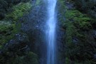
Dog Stream Waterfall
Photograph
•
Distance: 5.6km away
The Dog Stream waterfall, Upper Dog Stream track, just below link track to Mount Isobel
More ▶︎
Bottom Gordon Hut
Hut
•
Standard Hut (DOC). Capacity: 6.
•
Distance: 5.7km away
Hut next to Hut Stream on the Leatham River in the Leatham Conservation Area.
More ▶︎
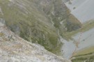
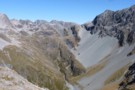
Elliott Stream
Photograph
•
Distance: 5.7km away
Descending into Elliott Stream ... peaks in the distance offering promise ...
More ▶︎
Thompson Pass
GPX file
•
Distance: 5.7km away
Caroline Creek Hut, Upper Waiau Valley to East Matakitaki Hut via Thompson Pass & Unamed Pass
More ▶︎

Thompson Pass
GPX file
•
Distance: 5.7km away
Caroline Creek Hut, Upper Waiau Valley to East Matakitaki Hut via Thompson Pass & Unamed Pass
More ▶︎
Caroline Creek Bivvy
Hut
•
Basic Hut/Bivvy (DOC). Capacity: 2.
•
Distance: 5.8km away
A nice little bivvy with 2 canvas bunks and an open fire
More ▶︎
Seymour / Forbes Hut
Hut
•
Standard Hut (DOC). Capacity: 10.
•
Distance: 5.8km away
Hut on the Clarence River near the Seymour River, and at the end of the 4WD route over Blind Saddle. ...
More ▶︎
Misty approach to Mount Isobel
Photograph
•
Distance: 6.2km away
Poled route ascends easily to the summit.
More ▶︎
View northwest from Mount Isobel
Photograph
•
Distance: 6.2km away
Waiau Toa / Clarence River in the distance.
More ▶︎
Lees Creek and Coldwater Stream
Track
•
2 days. Medium. Loop track with a road section.
•
Distance: 6.5km away
Upper Wairau Valley and Hells Gate
Two day tramp not marked past the Lees Creek hut.
Will need a mtb ...
More ▶︎
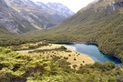
Upper Lees Creek Basin
Photograph
•
Distance: 6.5km away
Two nice tarns and great scenery are included in this tramp.
It is a remote and seldom visited area. We drank ...
More ▶︎

Upper Lees Creek
Photograph
•
Distance: 6.5km away
Upper Lees Creek basin being the true left hand side stream next to Coldwater Stream with tarns.
More ▶︎
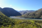
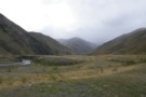
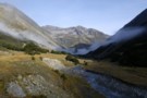
Clarence River
Photograph
•
Distance: 6.9km away
The mighty Clarence - from the start of the Molesworth East-West route above Seymour Hut. 1 or 3 crossings are ...
More ▶︎

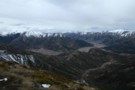
Upper Waiau Uwha River
Photograph
•
Distance: 7.0km away
Having descended from Waiau Pass, the photo is looking upstream to the start of the climb up the fault line ...
More ▶︎
Lake Thompson Panorama
Photograph
•
Distance: 7.1km away
Making dinner at Lake Thompson, alpine upper Waiau River.
Just outside of Nelson Lakes National Park
More ▶︎
Waiau Pass towards Thompson Pass
Photograph
•
Distance: 7.1km away
Looking nearly due south towards Lake Thompson (blue horizontal strip above my head), a very prominent fault to its right ...
More ▶︎
Descent from Lake Thompson
Photograph
•
Distance: 7.1km away
This is the route we took from our camp at the outlet of Lake Thompson down to the Waiau Valley ...
More ▶︎
Lake Thompson, Nelson Lakes
Photograph
•
Distance: 7.1km away
A good summer camping spot at Lake Thompson in the Nelson Lakes. This lake is at 1700m, at the head ...
More ▶︎
Lake Thompson, Nelson Lakes
Photograph
•
Distance: 7.1km away
A good summer camping spot at Lake Thompson in the Nelson Lakes. This lake is at 1700m, at the head ...
More ▶︎
Picton to Aspiring
GPX file
•
Distance: 7.1km away
An aborted alpine traverse. Picton to West Cape, but aborted at Aspiring due to real world emergencies back home. Posted ...
More ▶︎
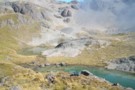
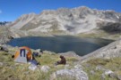
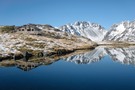
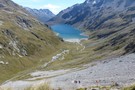
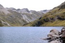
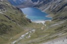
Lake Constance, Nelson Lakes
Photograph
•
Distance: 7.1km away
Lake Constance in the Nelson Lakes, viewed from the Waiau Pass
More ▶︎
Nelson Lakes National Park
Place
•
National Park. 1017.53km2.
•
Distance: 7.1km away
An alpine park of beech forests, valleys, and glacial lakes, offering some relatively easy walking. Established in 1956. Highest point: ...
More ▶︎
Lake Thompson
Photograph
•
Distance: 7.1km away
Lake Thompson, just below the Thompson Pass in the Nelson Lakes
More ▶︎

Blue Lake Hut - Bobs Hut
GPX file
•
Distance: 7.2km away
Blue Lake campsite to Bob’s Hut, via Lake Thompson and D’Urville Pass
An actual, recorded, gpx – the high route section ...
More ▶︎
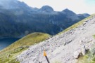
Waiau Pass
Photograph
•
Distance: 7.2km away
View south down to the Waiau River valley from Waiau Pass
More ▶︎
Waiau Hut
Hut
•
Standard Hut (DOC). Capacity: 6.
•
Distance: 7.3km away
New hut on the Waiau Pass Track and Te Araroa Trail. This hut was opened 27 January 2018, and constructed ...
More ▶︎
Lake Constance
Photograph
•
Distance: 7.3km away
Lake Constance, Nelson Lakes National Park. taken part way up to Waiau pass March 2003.
More ▶︎
St Arnaud to Lewis Pass
Track
•
5 – 9 days. Medium/hard. One way.
•
Distance: 7.3km away
A 5-9 day north-south route from St Arnaud to the Lewis Pass, via Travers Pass, Waiau Pass, Thompson Pass and ...
More ▶︎
St Arnaud - Lewis Pass
Article
•
Distance: 7.3km away
A 9-day 100km tramp via the Thompson, D'Urville and 3 Tarns Passes
Feb 2013
More ▶︎

Profile : St Arnaud - Lewis Pass
Photograph
•
Distance: 7.3km away
A useful profile of the 100km tramp - with a couple of bad weather alternatives :
1. low route past Speargrass ...
More ▶︎
Lake Constance
Photograph
•
Distance: 7.3km away
above the loose scree section of the climb to Waiau Pass (looking to Lake Constance) - easier going from here
Feb ...
More ▶︎
Nelson Lakes double figure eight with a reverse twist
Article
•
Distance: 7.4km away
January 2008.
A seven day epic up and over Lake Angelus from Speargrass Hut, then up the Sabine River, over Waiau ...
More ▶︎

Route Guide: St Arnaud to Lewis Pass
Article
•
Distance: 7.5km away
A 5-7 day north-south route from St Arnaud to the Lewis Pass, via Travers Pass, Waiau Pass, Thompson Pass and ...
More ▶︎

Lake Thompson
Photograph
•
Distance: 7.5km away
A view of the beautiful Lake Thompson, a short distance from Thompson Pass
More ▶︎

St James Conservation Area
Place
•
Place. 781.96km2.
•
Distance: 7.5km away
A large new recreational area featuring tussock grasslands, and including the headwaters of the Waiau and Clarence Rivers.
More ▶︎
Thompson Pass & Sth Island Alpine Fault line
Photograph
•
Distance: 7.5km away
A view from Waiau Pass which clearly shows the alpine fault line as it heads south through Thompson Pass.
More ▶︎
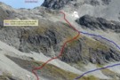
Thompson - D'Urville sidle
Photograph
•
Distance: 7.5km away
Cyan shows our actual route from Thompson Pass to D'Urville Pass. Red is Skiveoff's GPX route (downloadable from this website).
In ...
More ▶︎
The Saxton
Photograph
•
Distance: 8.0km away
Rain showers drift across the upper Saxton. The hut is at the forks in the mid-distance
More ▶︎
Severn Hut Dec 2013
Photograph
•
Distance: 8.1km away
A newish six bunker without a fire built in 2006. It's fenced to keep cattle out. It's on the DOC ...
More ▶︎
Severn hut
Hut
•
Standard Hut (DOC). Capacity: 6.
•
Distance: 8.1km away
A newish six bunker without a fire built in 2006. It's fenced to keep cattle out.
It's on the DOC East ...
More ▶︎
Upper D'Urville valley
Photograph
•
Distance: 8.3km away
Upper D'Urville valley, descending from Thompson Pass towards D'Urville Hut. Nelson Lakes.
More ▶︎

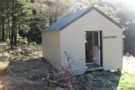
Island Gully Hut
Hut
•
Standard Hut (DOC). Capacity: 4.
•
Distance: 8.4km away
DOC Hut sited approx 200m off the Hanmer Springs-St. Arnaud Rd, which is a toll/gravel road. Features four bunks and ...
More ▶︎
Lake Constance
Photograph
•
Distance: 8.5km away
Looking south across the lake to Waiau Pass. The southern end of the lake is dammed by an ancient, massive ...
More ▶︎
Lake Constance
Photograph
•
Distance: 8.5km away
From the ascent to Waiau Pass.
Looking down the West Sabine valley.
More ▶︎
Wild toilet
Photograph
•
Distance: 8.5km away
Lake Tennyson Campsite. The view behind is the Clarence Valley. This is a standard Department of Conservation "Norski" brand fibreglass ...
More ▶︎
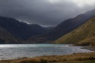
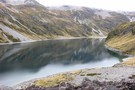
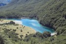
Lake Tennyson
Photograph
•
Distance: 8.5km away
The lake in a Norwester wind, from the campsite and shelter.
More ▶︎
Lake Tennyson Campsite
Campsite
•
Informal campsite (DOC). 10 spaces.
•
Distance: 8.5km away
Expansive campsite on the tussock shoreline of Lake Tennyson, on Molesworth Station. The campsite is close to the start of ...
More ▶︎
Lake Constance
Photograph
•
Distance: 8.6km away
View down to Lake Constance from Waiau Pass
More ▶︎
descent to the head of Lake Constance
Photograph
•
Distance: 8.6km away
after sidling across tussock grass, the descent from the bluff above the lake is pretty much tracked - and poled ...
More ▶︎
Lees Creek Hut
Hut
•
Standard Hut (DOC). Capacity: 4.
•
Distance: 8.6km away
Hut on Lees Creek east of the Wairau River. Alpine passes give access to Coldwater Creek and the Branch River. ...
More ▶︎
Sidling above Lake Constance
Photograph
•
Distance: 8.8km away
recent discussion about the track above Lake Constance (Campfire forum, Lake Constance - Waiau Pass Safety topic) has prompted me ...
More ▶︎
Bottom Misery Hut
Hut
•
Standard Hut (DOC). Capacity: 6.
•
Distance: 8.8km away
Hut with balcony at the junction of Misery and Branch Streams in the Leatham Conservation Area.
More ▶︎
Peters Valley Track
Photograph
•
Distance: 8.8km away
Near Tophouse Road behind Hanmer Springs.
More ▶︎
D'Urville Pass
Photograph
•
Distance: 8.8km away
an easier route (red) to D'Urville Pass
Feb 2013
More ▶︎
Saxton-Severn saddle
Photograph
•
Distance: 8.9km away
Saxton-Severn saddle - looking down the unnamed stream towards the Saxton from the pass
More ▶︎
Saxton Hut Dec 2013
Photograph
•
Distance: 8.9km away
A six bunk hut with a woodburner stove newly erected at this site in April 2012. This is the 3rd ...
More ▶︎
Saxton Hut
Hut
•
Standard Hut (DOC). Capacity: 6.
•
Distance: 8.9km away
A six bunk hut with a woodburner stove newly erected at this site in April 2012. This is the 3rd ...
More ▶︎
Crossing Maling Pass
Photograph
•
Distance: 9.1km away
The climb to the pass is easy, but it is deceptively high: 1308m. Over the pass is Mount Una (2300m) ...
More ▶︎
Lake Constance
Photograph
•
Distance: 9.2km away
from the bolder field above the lake, near the track to Waiau Pass - Apr 2011
More ▶︎
Maling Pass to Lake Guyon junction
GPX file
•
Distance: 9.4km away
Northernmost section of the St James Cycle Trail
More ▶︎
Maling Pass to Lake Guyon
GPX file
•
Distance: 9.4km away
From Lake Tennyson, cross Maling Pass into the deep Waiau Valley, then turn off to Lake Guyon.
More ▶︎
Barbers Hut
Hut
•
Standard Hut (DOC). Capacity: 6.
•
Distance: 9.6km away
Small hut opposite Barber Stream on the Leatham 4WD Road up the Leatham River.
More ▶︎
![Goose Flat Hut [Destroyed]](http://tramper.nz/imgcache/25/25093-mini.jpg)
Goose Flat Hut [Destroyed]
Hut
•
Standard Hut (DOC). Capacity: 10.
•
Distance: 9.6km away
Hut on Goose Flat, next to the Clarence River.
This hut was destroyed by a 300 hectare backcountry fire 28 January ...
More ▶︎
Blue Lake, Nelson Lakes
Photograph
•
Distance: 9.7km away
Blue Lake in the Nelson lakes. Viewed from the moraine wall below Lake Constance.
More ▶︎
Limestone Hut
Hut
•
Standard Hut (DOC). Capacity: 4.
•
Distance: 9.7km away
Small hut located next to Limestone Stream on the Seaward Kaikoura Range.
More ▶︎