Nearby
Walking the length of the Richmond Ranges
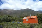
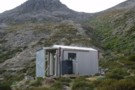
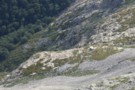
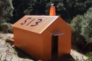
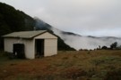
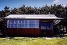
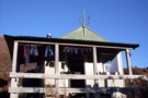
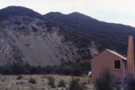
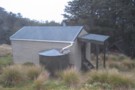
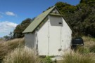
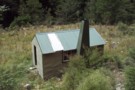
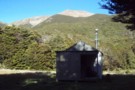
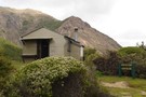
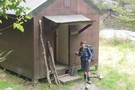
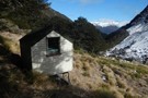
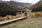
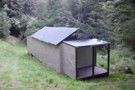
New Porters Creek Hut
Photograph
•
Distance: 160m away
moved to spot from right branch wairoa.
has beenlovingly restored with a new lick of 'rescue orange' paint and sports a ...
More ▶︎
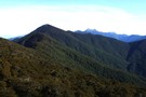
Route Guide: Richmond Ranges (west) main ridge
Article
•
Distance: 160m away
The main ridge of the western Richmond Ranges from Mt Riley, near Okamario on SH6 to the Red Hills above ...
More ▶︎
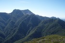
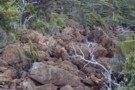
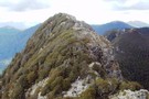
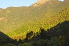
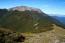
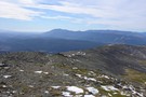
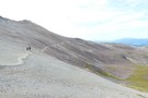
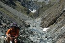
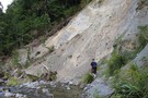
Red Hill
Photograph
•
Distance: 160m away
Red Hill, ascending from Top Wairoa Hut. The whole range appears to consist of nothing more than loose, rad, abrasive ...
More ▶︎
Red Hills Ridge Traverse
GPX file
•
Distance: 251m away
Traverse of the Red Hills Ridge beginning from the Red Hills car park, returning via Mt Ellis, Hunters Hut, Porters ...
More ▶︎
St Arnaud to Lewis Pass
Track
•
5 – 9 days. Medium/hard. One way.
•
Distance: 368m away
A 5-9 day north-south route from St Arnaud to the Lewis Pass, via Travers Pass, Waiau Pass, Thompson Pass and ...
More ▶︎
Picton to Aspiring
GPX file
•
Distance: 585m away
An aborted alpine traverse. Picton to West Cape, but aborted at Aspiring due to real world emergencies back home. Posted ...
More ▶︎
Nelson Lakes - Lakehead, Angelus and Speargrass Circuit
GPX file
•
Distance: 673m away
From St Arnaud along Lake Rotoiti to Lakehead Hut, then crossing the Travers River and via the Cascade Track to ...
More ▶︎
Travers-Sabine
Track
•
4 – 7 days. Medium. Loop track with a road section.
•
Distance: 816m away
Two river valleys linked by a straightforward alpine saddle at 1800m
More ▶︎

Route Guide: St Arnaud to Lewis Pass
Article
•
Distance: 816m away
A 5-7 day north-south route from St Arnaud to the Lewis Pass, via Travers Pass, Waiau Pass, Thompson Pass and ...
More ▶︎

Lake Thompson
Photograph
•
Distance: 816m away
A view of the beautiful Lake Thompson, a short distance from Thompson Pass
More ▶︎
Travers-Sabine Saddle
Photograph
•
Distance: 816m away
Going over the saddle looking west towards the Sabine Valley - April 2010.
More ▶︎
Saint Arnaud
Place
•
Place.
•
Distance: 817m away
An alpine village on the shore of Lake Rotoiti in Nelson Lakes National Park.
More ▶︎

Te Araroa Trail
Track
•
95 days. Medium. One way.
•
Distance: 817m away
Te Araroa is a walking trail running the entire length of the North and South Islands. The trail opened 3 ...
More ▶︎
Kerr Bay campsite
Campsite
•
Basic Campsite (DOC). 21 spaces.
•
Distance: 916m away
Grassy lakeside camping surrounded by a wealth of walking options, from short walks to alpine tops trips and multi-day tramps. ...
More ▶︎
Loop Track, Lake Rotoiti
Track
•
Easy. Loop track.
•
Distance: 928m away
A short walk through the Rotoiti Nature Recovery Project at St Arnaud. Lakeside beech forest.
More ▶︎
Honeydew Walk, Lake Rotoiti
Track
•
Easy. Loop track.
•
Distance: 928m away
This short loop leads into the edges of the Rotoiti Nature Recovery Project area, a "mainland island" with pest numbers ...
More ▶︎
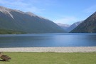
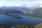
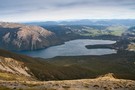
Lake Rotoiti
Photograph
•
Distance: 935m away
from the shore of St Arnaud, looking to the head of the lake and up the Travers Valley - Apr ...
More ▶︎
Gibbs Walk
Track
•
Easy. One way.
•
Distance: 975m away
Short link track betweem St Arnaud village and campground.
More ▶︎
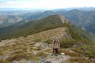
Mount Fishtail
Track
•
1 day. Easy/medium. Return by the same track.
•
Distance: 1.0km away
A moderate day hike to the summit of Mount Fishtail a prominent peak in the Richmond Range. Great views can ...
More ▶︎
Black Valley Walk
Track
•
Easy. One way.
•
Distance: 1.1km away
Link track between St Arnaud village and the campground.
More ▶︎
Anglers Walk, Lake Rotoiti
Track
•
Easy. One way.
•
Distance: 1.4km away
This track follows the first 2km of the Buller River from its source at Lake Rotoiti. It is well used ...
More ▶︎
Mt Fishtail
Photograph
•
Distance: 1.6km away
Mount Fishtail, Richmond Ranges. The ridge in the foreground leads to Mt Fell, and is steep in places... where it's ...
More ▶︎
Wairau valley from Fishtail Hut
Photograph
•
Distance: 1.6km away
Wairau valley from Fishtail Hut
More ▶︎
Fishtail Hut from Mt Fishtail
Photograph
•
Distance: 1.6km away
Fishtail Hut from Mt Fishtail
More ▶︎
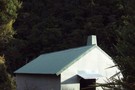
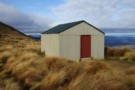
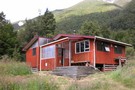
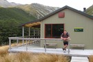
Fishtail Hut
Hut
•
Standard Hut (DOC). Capacity: 4.
•
Distance: 1.6km away
Fishtail hut (4 bunk, matresses, tank water, no fire) is located on a plateau half way up the scree face ...
More ▶︎
Red Hills Hut
Hut
•
Basic Hut/Bivvy (DOC). Capacity: 6.
•
Distance: 1.7km away
The Red Hills Hut sits on the saddle between the Motueka (right branch) and the Wairau, and at the base ...
More ▶︎
Route Guide: Richmond Ranges (east)
Article
•
Distance: 2.1km away
Tramping in the eastern Richmond Ranges between Picton and Okaramio (SH6)
More ▶︎
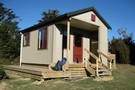
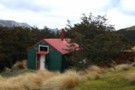
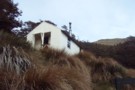
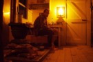
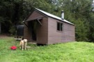
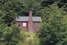
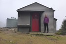
Top Wairoa Hut March 2014
Photograph
•
Distance: 2.1km away
This photo shows the hut after its fairly recent maintenance. A paint job & clearance of scrub from around the ...
More ▶︎
Top Wairoa Hut
Photograph
•
Distance: 2.2km away
Top Wairoa Hut, from the ascent to Mt Elliss / Red Hill
More ▶︎
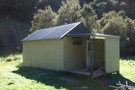
Top Wairoa Hut
Hut
•
Standard Hut (DOC). Capacity: 6.
•
Distance: 2.2km away
Top Wairoa hut (6 bunks, matresses, fire - limited scrubby firewood, river water) huddles amidst Manuka scrub above the north ...
More ▶︎
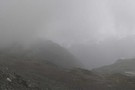
Ascent to Red Hill / Ellis Peak from Top Wairoa.
Photograph
•
Distance: 2.2km away
Ascent to Red Hill / Ellis Peak from Top Wairoa.
More ▶︎
Nelson Lakes National Park
Place
•
National Park. 1017.53km2.
•
Distance: 2.3km away
An alpine park of beech forests, valleys, and glacial lakes, offering some relatively easy walking. Established in 1956. Highest point: ...
More ▶︎
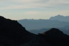
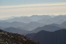
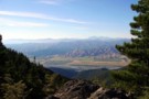
Kaikoura Ranges
Photograph
•
Distance: 2.5km away
View from Mt. Richmond, over the Marlborough region.
2 days before leaving, my last tramp in New Zealand...
More ▶︎
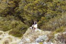
Richmond Range - country fit for mountain goats!
Photograph
•
Distance: 2.9km away
Goats rule on the main Richmond Range from Richmond Saddle to Ada Flats.
More ▶︎
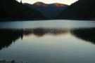
Richmond Saddle Hut
Hut
•
Standard Hut (DOC). Capacity: 6.
•
Distance: 2.9km away
Hut near Mt. Richmond, on the saddle, nice view to Nelson Bay, and Abel Tasman. Beautiful sunset.
More ▶︎
Paddy's Pinchgut circuit
Track
•
Easy. Loop track.
•
Distance: 3.2km away
Mt Robert carpark to carpark via Paddy Track, Bushline hut, Relax Shelter and Pinchgut track - 4 hours. 575m up ...
More ▶︎
Paddy's Pinchgut circuit
Photograph
•
Distance: 3.2km away
Great morning or afternoon walk with great lake and mountain views.
More ▶︎

Profile : St Arnaud - Lewis Pass
Photograph
•
Distance: 3.3km away
A useful profile of the 100km tramp - with a couple of bad weather alternatives :
1. low route past Speargrass ...
More ▶︎

St Arnaud - Lewis Pass
Article
•
Distance: 3.3km away
A 9-day 100km tramp via the Thompson, D'Urville and 3 Tarns Passes
Feb 2013
More ▶︎
Richmond Range (pt 1424)
Photograph
•
Distance: 3.3km away
Richmond Range between Richmond Saddle and Ada Flats. A rough, but interesting route from Richmond Saddle Hut to Old Man ...
More ▶︎
Legal access points from Kenningtons Road to the Richmond Ranges
Photograph
•
Distance: 3.5km away
Legal access points from Kenningtons Road to the Richmond Ranges - note that these access points are along paper roads ...
More ▶︎
Mt Royal
Track
•
1 day. Easy/medium. Return by the same track.
•
Distance: 3.7km away
Park at camp ground, walk Quartz Creek to track start, follow spur up to saddle, then above the tree line ...
More ▶︎
Bushline Hut
Hut
•
Standard Hut (DOC). Capacity: 14.
•
Distance: 4.1km away
A cute hut with a grand outlook over Lake Rotoiti and down to St Arnaud. Loo with a view!
More ▶︎
Kea hut Nov 2012
Photograph
•
Distance: 4.3km away
An older but lovingly restored hut in the Mt Robert area of Nelson Lakes National Park. This hut is only ...
More ▶︎
Kea hut
Hut
•
Private hut (NA).
•
Distance: 4.3km away
An older but lovingly restored hut in the Mt Robert area of Nelson Lakes National Park. This hut is only ...
More ▶︎
Relax Shelter
Hut
•
Shelter (DOC).
•
Distance: 4.3km away
Basic shelter on Robert Ridge (Mt Robert, Nelson Lakes National Park)
More ▶︎
Relax Shelter Nov 2012
Photograph
•
Distance: 4.3km away
On the Pinchgut track Mt Robert close to the junction with Paddys track and the Robert Ridge route.
More ▶︎
St Arnaud Range Track
Track
•
1 day. Medium. Return by the same track.
•
Distance: 4.8km away
This walk climbs steadily through beech forest to a height of over 1650 metres.
Above the bushline (at 1400 m), ...
More ▶︎
Parachute Rocks Track
Photograph
•
Distance: 4.9km away
View of Lake Rotoiti from point 1738
More ▶︎
Red Hills Range
Photograph
•
Distance: 5.0km away
Red Hills Range, Richmond Ranges with the Wairoa in the distance.
More ▶︎
Havelock, from pt1045
Photograph
•
Distance: 5.1km away
Havelock, from pt1045 in the eastern Richmond Ranges
More ▶︎
Hunters Hut
Hut
•
Standard Hut (DOC). Capacity: 8.
•
Distance: 5.5km away
Standard 8 bunk hut on the Te Araroa trail.
More ▶︎
Hunters hut (Mt Richmond)
Hut
•
Standard Hut (DOC). Capacity: 8.
•
Distance: 5.5km away
cosy 8 bunk hut on ridge left branch motueka river not that easy to find on old maps
More ▶︎
Maitland Hut
Hut
•
Basic Hut/Bivvy (DOC). Capacity: 4.
•
Distance: 5.7km away
A basic four bunk hut situated on the banks of the Right Branch Motueka River in the Mt Richmond Forest ...
More ▶︎
Maitland Hut
Photograph
•
Distance: 5.7km away
Not sure what happened to this hut. But it was in a great possy amongst the ultra mafic rocks with ...
More ▶︎
Mt Rintoul from Old Man
Photograph
•
Distance: 5.8km away
Looking back towards Rintoul From Old Man. Old Man Hut lies 1km off ridge to the left of the saddle.
More ▶︎
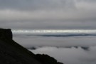
View over Silverstream and down Raglan Range
Photograph
•
Distance: 5.9km away
I took this photo looking generally southward when high on the Raglan Range. I was heading to Silverstream Bivvy and ...
More ▶︎
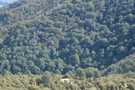
Mt. Fell Hut (Richmond Ranges)
Photograph
•
Distance: 5.9km away
Mt Fell Hut in the Richmond Ranges, with Mount Fell summit behind.
More ▶︎
Mt Fell Hut
Hut
•
Standard Hut (DOC). Capacity: 6.
•
Distance: 5.9km away
Mount Fell Hut (sleeps 6, wood-burning stove, firewood available, tank water). The hut lies just inside the bush below Mt ...
More ▶︎
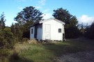
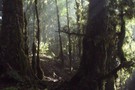
Porter Hut
Photograph
•
Distance: 6.0km away
This is an older photo of the hut, set in the lunar landscape of the Red Hills. I think the ...
More ▶︎
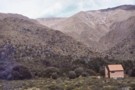
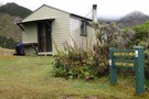
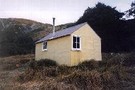
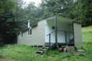
Porters Creek Hut
Hut
•
Standard Hut (DOC). Capacity: 6.
•
Distance: 6.0km away
A basic hut on the edge of the Red Hills mineral belt.
More ▶︎
Mount Riley, Marlborough
Photograph
•
Distance: 6.0km away
From the Summit of Mount Riley, looking northeast. 15-10-09
More ▶︎
Mt Fell from the North Bank
Track
•
2 days. Medium.
•
Distance: 6.3km away
A steady climb which rewards your efforts with fabulous views of the Wairau Plains, Nelson/Tasman Bay and beyond.
More ▶︎
Slaty Hut
Hut
•
Standard Hut (DOC). Capacity: 6.
•
Distance: 6.3km away
On the Mt Richmond Alpine Route.
More ▶︎
Mt Richmond Alpine Route
Track
•
5 days. Medium. One way.
•
Distance: 6.3km away
Long route above the bushline in Mt Richmond Forest Park near Nelson.
More ▶︎
Silverstream Bivvy Jan 2019
Photograph
•
Distance: 6.5km away
A nice Marlborough biv in the Branch catchment of the Raglan Range that gets few visitors.
More ▶︎
Silverstream Bivvy
Hut
•
Basic Hut/Bivvy (DOC). Capacity: 2.
•
Distance: 6.5km away
Weatherboard and iron biv located near the treeline on the Raglan Range. The biv is not on Silverstream itself but ...
More ▶︎
Devils Creek Hut
Hut
•
Standard Hut (DOC). Capacity: 6.
•
Distance: 7.0km away
A tidy hut on the Wakamarina Track. Has wood-burner.
More ▶︎
Robert Ridge
Photograph
•
Distance: 7.1km away
looking down the ridge from Flagtop - Apr 2011
More ▶︎
Mount Richmond Forest Park
Place
•
Conservation Park. 1660.00km2.
•
Distance: 7.3km away
A wedge of land at the base of the Marlborough Sounds, south of Nelson and north of the Wairau River, ...
More ▶︎
Mt Sunday Bivy
Photograph
•
Distance: 7.4km away
Small 2 bunk bivy on the Mt Sunday - Mt Riley track, Mt Richmond Forest Park.
More ▶︎
Mt Sunday Biv
Hut
•
Basic Hut/Bivvy (DOC). Capacity: 2.
•
Distance: 7.4km away
Mt Sunday biv
More ▶︎
Mt Sunday / Mt Riley Track
Track
•
1 – 2 days. Medium. Loop track.
•
Distance: 7.7km away
A circuit track on the Richmond Range, visiting two forested summits.
More ▶︎
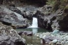
Waterfall, Wairoa left branch.
Photograph
•
Distance: 7.7km away
The waterfall and pool at the 1st creek crossing of the Wairoa above Mid Wairoa Hut, Richmond Ranges.
More ▶︎
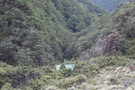
Mid Wairoa Hut
Hut
•
Standard Hut (DOC). Capacity: 6.
•
Distance: 7.7km away
Mid Wairoa Hut (6 bunks, matresses, tank & river water, stove) sits on flats 20m above the Left Branch of ...
More ▶︎
Coldwater hut
Hut
•
Standard Hut (DOC). Capacity: 12.
•
Distance: 7.8km away
A concrete hut with 12 bunks. When I was there during the Summer the fire had been removed to prevent ...
More ▶︎
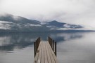
Coldwater Hut
Photograph
•
Distance: 7.8km away
The hut, from the Lakehead jetty, looking across Lake Rotoiti - Apr 2011
More ▶︎
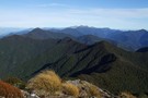
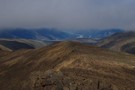
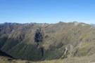
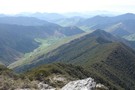
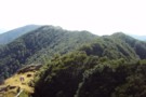
Ridgeline travel in the eastern Richmond Ranges
Photograph
•
Distance: 8.1km away
Ridgeline travel in the eastern Richmond Ranges
More ▶︎
Richmond Ranges (east)
Photograph
•
Distance: 8.1km away
Richmond Ranges (east), north from pt1045
More ▶︎
Old Man Hut
Hut
•
Standard Hut (DOC). Capacity: 6.
•
Distance: 8.1km away
Old Man Hut (sleeps 6, wood-burning stove, firewood available, tank & stream water) sits in a large grassy clearing between ...
More ▶︎
Roebuck Hut
Hut
•
Standard Hut (DOC). Capacity: 6.
•
Distance: 8.2km away
A remote, cosy hut in a great location (sandflies!) within the Richmond Forest Park near Nelson.
More ▶︎
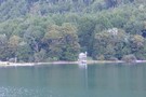
Lakehead hut
Photograph
•
Distance: 8.3km away
Lakehead hut close to Lake Rotoiti in Nelson Lakes National Park
More ▶︎
Lakehead Hut
Hut
•
Standard Hut (DOC). Capacity: 28.
•
Distance: 8.3km away
A large modern hut. Lots of sandflies. Note that access to Coldwater Hut across the valley is either a 2-3 ...
More ▶︎
Ben Nevis
Track
•
1 day. Easy/medium. Return via same track.
•
Distance: 8.5km away
Relatively steep climb to the summit of Ben Nevis (1619m), a prominent peak in the Mt Richmond Forest Park South-East ...
More ▶︎
Ben Nevis
Photograph
•
Distance: 8.5km away
looking down the ridge from Ben Nevis towards Nelson.
More ▶︎
Robert Ridge
Photograph
•
Distance: 8.5km away
looking NE along the ridge - in good weather, the views are expansive.
More ▶︎
Robert Ridge in the Rain
Photograph
•
Distance: 8.6km away
On our last day, we decided to walk out from Speargrass Hut via Robert Ridge (to avoid retracing our walk ...
More ▶︎
Starveall Hut
Hut
•
Standard Hut (DOC). Capacity: 6.
•
Distance: 8.8km away
A standard DOC hut with six bunks and a wood burner situated on the bushline 45 minutes below the ridge ...
More ▶︎
Starveall Hut
Photograph
•
Distance: 8.8km away
This hut is in a top spot and has an Awesome View.
More ▶︎
Mt Baldy
Photograph
•
Distance: 9.0km away
This photo has been posted to illustrate the existing route description for climbing Mt Baldy. Mt Baldy 1315m is behind ...
More ▶︎
Nelson Lakes double figure eight with a reverse twist
Article
•
Distance: 9.0km away
January 2008.
A seven day epic up and over Lake Angelus from Speargrass Hut, then up the Sabine River, over Waiau ...
More ▶︎
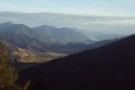
Wairau views
Photograph
•
Distance: 9.0km away
Wairau views from road-side lookout on Staircase road.
More ▶︎
Pelorus Track (via Rocks hut & Totara saddle)
Track
•
2 – 3 days. Easy/medium. One way.
•
Distance: 9.1km away
The Pelorus track is a semi-remote forest experience in Mount Richmond Forest park.It leads up the Pelorus valley and over ...
More ▶︎
Bull Paddock Creek Track
GPX file
•
Distance: 9.1km away
GPS file of track from Bull Paddock Creek Biv to the Wairau River
More ▶︎
Bull Paddock Creek Track
Track
•
1 – 3 days. Medium. Return by the same track.
•
Distance: 9.1km away
Access To Bull Paddock Creek Biv from The Wairau river, this track follows Sand Fly Stream before dropping Bull Paddock ...
More ▶︎
Dukeshead, Richmond Ranges
Photograph
•
Distance: 9.3km away
Dukeshead: ridgeline travel in the eastern Richmond Ranges
More ▶︎
Speargrass Hut
Photograph
•
Distance: 9.3km away
The old small cosy hut at the top of a clearing. Since replaced by a modern hut.
Water from Speargrass Creek ...
More ▶︎
Speargrass Hut
Hut
•
Standard Hut (DOC). Capacity: 12.
•
Distance: 9.3km away
Previously a small cosy hut, but now a brand new roomy hut with two sleeping platforms, L shaped stainless steel ...
More ▶︎
Speargrass slip
Photograph
•
Distance: 9.3km away
One of a number of slips to negotiate back to the car park.
More ▶︎

The new Speargrass Hut
Photograph
•
Distance: 9.3km away
Same layout as Morgan. Two sleeping platforms for 10 people in total. Stainless steel L shaped bench. Table, fixed benches, ...
More ▶︎
Lake Chalice Hut
Photograph
•
Distance: 9.6km away
Tidy large hut near Northbank/Topline roadend (40 mins/2 km) and of course Lake Chalice. Great for a day trip or ...
More ▶︎
Lake Chalice Hut
Photograph
•
Distance: 9.6km away
Tidy 1963 vintage hut near Northbank/Topline/Staircase car park (40 mins / 2 km) and of course Lake Chalice. Great for ...
More ▶︎
Lake Chalice Hut
Hut
•
Standard Hut (DOC). Capacity: 8.
•
Distance: 9.6km away
South Marlborough Hut near the end of Northbank/Topline/Staircase Roads, with water from a stream, and the lake 5 minutes further.
More ▶︎
Mid Silverstream Hut
Hut
•
Standard Hut (DOC). Capacity: 5.
•
Distance: 9.8km away
Located on Silverstream, off the Branch River.
Note that Silverstream Biv is not upstream of this hut, but is at the ...
More ▶︎
Starveall Hut (Richmond Ranges)
Photograph
•
Distance: 9.8km away
A tidy 6 bunk hut on the bushline in the Richmond Ranges.
Read my trip report on my blog http://waitakathlete.blogspot.co.nz/2017/07/solo-to-starveall.html
I couldn't ...
More ▶︎
Lower Goulter hut Nov 2013
Photograph
•
Distance: 9.9km away
This hut is close to a 4x4 road end & it shows a bit. Empty booze bottles, other litter, smut ...
More ▶︎
Bull Paddock Creek Hut
Hut
•
Basic Hut/Bivvy (DOC). Capacity: 2.
•
Distance: 9.9km away
Hut on the Raglan Range, east of the Wairau River. The hut is located near the bush line in Bull ...
More ▶︎
Starveall Hut
Photograph
•
Distance: 9.9km away
Nicely situated hut overlooking Nelson and bay in the Richmond Forest Park.Nearby residents include a nosey woodhen who enjoys smelly ...
More ▶︎
Lower Goulter Hut
Hut
•
Standard Hut (DOC). Capacity: 8.
•
Distance: 9.9km away
Lower Goulter hut
More ▶︎