Nearby
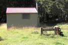
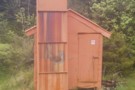
Boyle Flats Hut
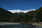
St James Walkway June 2009
Photograph
•
Distance: less than 100m away
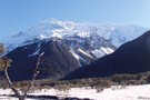
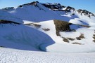
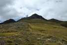
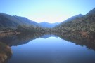
Gloriana and the Faerie Queene, on a brilliant winter's day.
More ▶︎
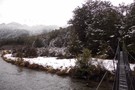
Magdalen Valley
Photograph
•
Distance: less than 100m away
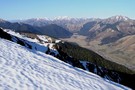
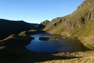
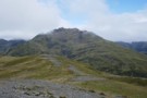
View east over Magdalen Valley to Waiau from Faust
More ▶︎
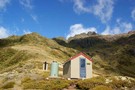
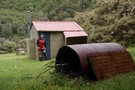
Boyle Flats Hut
Photograph
•
Distance: less than 100m away
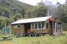
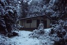
Perched high on a river terrace, accessed from a swingbridge 'on the Boyle'.
More ▶︎

St James Conservation Area
Place
•
Place. 781.96km2.
•
Distance: less than 100m away
A large new recreational area featuring tussock grasslands, and including the headwaters of the Waiau and Clarence Rivers.
More ▶︎
St James Walkway
Track
•
5 days. Easy/medium. One way.
•
Distance: less than 100m away
A long and easy walk on St James Station near Lewis Pass. Beech forest, mountain scenery, farmland, wild horses, mud.
More ▶︎
Ada Cullers Hut
Photograph
•
Distance: less than 100m away
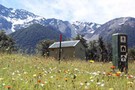
Tidy old shack provides shelter and shade from the elements. No mattresses or water supply.
More ▶︎
Boyle Village - Mt Faust - Boyle Hut
Track
•
1 day. Medium. One way.
•
Distance: less than 100m away
A great trip over the top of Mt Faust and down a spur to Boyle Hut on the St James ...
More ▶︎
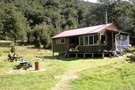
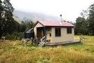
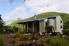
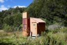
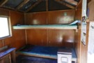
Boyle Flat Hut
Photograph
•
Distance: 273m away
Boyle Flats Hut is the last hut on the Saint James Walkway (north to south)
More ▶︎
Mephistopheles
Photograph
•
Distance: 3.3km away
One of the named peaks along the Libretto Range, which runs from Lewis Pass to Boyle Village.
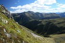
The ridge to Faust ...
More ▶︎
Lake Sumner Conservation Park
Place
•
Conservation Park. 1057.71km2.
•
Distance: 3.4km away
Lakes and forested hills in this sprawling park provide good tramping, and contrast with the rugged alpine environment of Arthur's ...
More ▶︎
Rokeby Hut
Photograph
•
Distance: 3.5km away
Rokeby Hut is an old cullers hut about 1 hour upstream from the Boyle Flats Hut. Three canvas bunks and ...
More ▶︎
Rokeby Hut
Hut
•
Basic Hut/Bivvy (DOC). Capacity: 3.
•
Distance: 3.6km away
Hidden on a high bench above the Boyle River. Three canvas bunks, 2 cute seats and a woodstove make for ...
More ▶︎
Magdalen Hut 2011
Photograph
•
Distance: 3.9km away
Magdalen Hut is on the Boyle River. 15 to 20 minutes downstream from the swingbridge between Boyle Flats Hut and ...
More ▶︎
Magdalen Hut
Hut
•
Standard Hut (DOC). Capacity: 6.
•
Distance: 3.9km away
Magdalen Hut is the 3rd incarnation on this paddock. Built in 2008, it's sparky and shiny, with 6 bunks.
More ▶︎
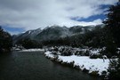
Lewis River
Photograph
•
Distance: 4.9km away
Lewis River near Palmer Lodge at the start of the Nina Valley Track, October 2009.
More ▶︎
Lucretia Hut Route
Track
•
1 day. Easy/medium. Return by the same track.
•
Distance: 5.0km away
Lucretia biv via Nina Valley
More ▶︎
Nina River
Track
•
2 days. Easy. Return by the same track.
•
Distance: 5.5km away
Easy tramping up a pretty river valley near Lewis Pass.
More ▶︎
Sylvia Flats
Track
•
Easy. Return via same track.
•
Distance: 6.5km away
Roadside hot pools near Lewis Pass
More ▶︎
Sylvia Flats
Campsite
•
Private Hut (Not applicable).
•
Distance: 6.5km away
A marked rest area on SH7 near Lewis Pass, with ample space to stop and camp as well as hot ...
More ▶︎
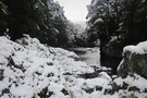
Nina River First Swing Bridge ~ Snowy
Photograph
•
Distance: 6.7km away
The first swing bridge, in winter, gorgeous
More ▶︎
Steyning Hut
Hut
•
Basic Hut/Bivvy (DOC). Capacity: 6.
•
Distance: 8.2km away
Hut located on the edge of Lake Sumner Forest Park.
More ▶︎
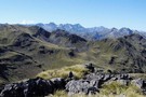
Trovatore Peak
Photograph
•
Distance: 8.3km away
The ridge to Trovatore Peak from Travers peak
More ▶︎
Top of Travers Peak
Photograph
•
Distance: 8.3km away
View north from Travers Peak towards Gloriana Peak and the Fairie Queen
More ▶︎
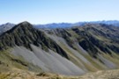
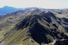
Libretto Range
Photograph
•
Distance: 8.3km away
View south along Libretto Range from Travers Peak
More ▶︎
Foleys Creek Track - Travers Peak
Track
•
1 day. Medium. Return via same track.
•
Distance: 8.3km away
A poled route to the summit of Travers Peak near Lewis Pass
More ▶︎
Travers Peak - Trovatore - Henry Saddle
Track
•
2 days. Medium. Loop track.
•
Distance: 8.3km away
An interesting circuit exploring the alpine tops around Lewis Pass.
More ▶︎
Deer Valley Campsite
Campsite
•
Informal campsite (DOC). 10 spaces.
•
Distance: 8.4km away
A minimal roadside camping area near Lewis Pass. Water is available from the nearby stream. Foleys Creek and Rolleston Pack ...
More ▶︎

Te Araroa Trail
Track
•
95 days. Medium. One way.
•
Distance: 8.5km away
Te Araroa is a walking trail running the entire length of the North and South Islands. The trail opened 3 ...
More ▶︎
Lewis Pass National Reserve
Place
•
Reserve. 182.95km2.
•
Distance: 8.7km away
A small park occupying the forested valleys around Lewis Pass and bordering Lake Sumner and Victoria Forest Parks as well ...
More ▶︎
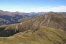
Lewis Tops from Travers Peak
Photograph
•
Distance: 8.9km away
Lewis Tops and Mount Technical are in the distance. The spur southwest of Trovatore is closer, and the northern slopes ...
More ▶︎
Rolleston Pack Track
Track
•
Easy. One way.
•
Distance: 9.3km away
An old pack track near Lewis Pass. This is a pleasant forest walk, and an alternative to walking along the ...
More ▶︎
Devils Rampart
Photograph
•
Distance: 9.5km away
from the Sylvia tops, the Devils Rampart is slowly revealed as the mists begin to lift - Feb 2018
More ▶︎
Lucretia biv
Photograph
•
Distance: 9.9km away
a good lunch stop on the route to the tops - Feb 2018
More ▶︎
Lucretia Hut
Hut
•
Basic Hut/Bivvy (DOC). Capacity: 2.
•
Distance: 9.9km away
Very basic 2 bunk hut with open fire in the head of Lucretia Stream, Lewis Pass area
More ▶︎
Lucretia biv
Photograph
•
Distance: 9.9km away
inside the biv - basic but welcome in bad weather - Feb 2018
More ▶︎
Carlyle Hut
Hut
•
Basic Hut/Bivvy (DOC). Capacity: 8.
•
Distance: 10.0km away
Hut on Carlyle Stream, an obscure corner of Lake Sumner Conservation Park beneath the Poplars Range. Generally visited by hunters.
More ▶︎