Nearby
Ahaura River
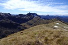
Safety Camp Creek Basin & Pt 1462m
Photograph
•
Distance: 1.3km away
This photo was taken from the Elliot tops above the Ahaura and Clarke Rivers on the West Coast. It looks ...
More ▶︎
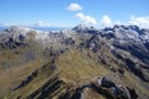
Elliot tops
Photograph
•
Distance: 1.5km away
This photo looks north along the Elliot tops from Point 1388m just north of Mt Elliot. It is Troulands Creek ...
More ▶︎
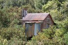
Hamers Flat
Hut
•
Basic Hut/Bivvy (NA). Capacity: 2.
•
Distance: 8.5km away
Derelict hut from the days when gold miners walked & stock were driven from Canterbury through the Amuri Pass and ...
More ▶︎
Hamers Flat hut
Photograph
•
Distance: 8.5km away
Semi derelict historic hut from the days when stock were driven from Canterbury through the Amuri Pass and down the ...
More ▶︎
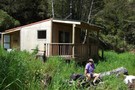
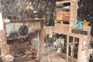
Jims Flat hut Nov 2009
Photograph
•
Distance: 10.0km away
This photo was taken after a rebuild & extensions to the original hut had been completed. The hut is located ...
More ▶︎
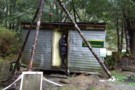
Jims Flat hut Oct 2007
Photograph
•
Distance: 10.0km away
This shot was taken during the early stages of the rebuild. Compare it to the current look and you will ...
More ▶︎
Jims Flat hut
Hut
•
Basic Hut/Bivvy (DOC). Capacity: 5.
•
Distance: 10.0km away
It looks new but it is an old hut that has been rebuilt and extended. Situated beside the Ahaura River ...
More ▶︎