Nearby
Black Hill
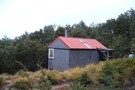
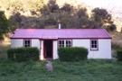
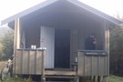
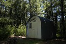
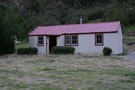
Black Hill Hut
Hut
•
Standard Hut (DOC). Capacity: 6.
•
Distance: less than 100m away
Six bunk just below the bushline in dry beech forest on Black Hill. Enclosed wood burner, rainwater supply; nice and ...
More ▶︎
Black Hill Hut, Oxford Forest
Photograph
•
Distance: less than 100m away
Six bunk hut just below the bushline
More ▶︎

Wharfedale Hut / Black Hill Hut loop and return
Track
•
2 – 3 days. Easy/medium. Return via same track.
•
Distance: less than 100m away
We were waiting for a good settled weekend to get into the hills. Alot of snow damaged branches along the ...
More ▶︎
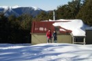
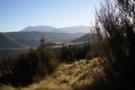
Black Hill hut in Winter
Photograph
•
Distance: less than 100m away
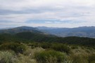
Boys at Black Hill hut with a view of Mt Oxford
More ▶︎
Black Hill hut in Winter
Photograph
•
Distance: less than 100m away
Boys at Black Hill hut with a view of Mt Oxford
More ▶︎
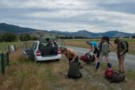
Getting started
Photograph
•
Distance: less than 100m away
The traditional start: five trampers and packs crowd into a compact car then drive 1.5 hours. Townshend Track in the ...
More ▶︎
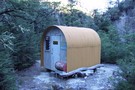
Salmon Creek Lower Bivvy
Hut
•
Basic Hut/Bivvy (DOC). Capacity: 2.
•
Distance: 2.2km away
Last model of NZFS 2 person bivvy (as per Bob's Biv). Curved, corrugated iron cladding with internal plywood lining of ...
More ▶︎
Ladbrooks Hill Track from Ashley Gorge
Track
•
Easy. Return by the same track.
•
Distance: 3.0km away
500m developed track to take you to the tops in the Mt Thomas forest and possible further circuits.
More ▶︎
Walker Hut
Hut
•
Basic Hut/Bivvy (DOC).
•
Distance: 4.0km away
Hut on the Waimakariri Gorge near Broken River, part of Oxford Forest Conservation Area.
More ▶︎
Mount Oxford
Track
•
1 day. Easy/medium. Loop track.
•
Distance: 6.2km away
A loop track leading over the summit of Mount Oxford and back through the foothill forest.
More ▶︎
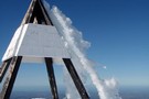
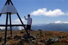
Mt Oxford Summit in Winter
Photograph
•
Distance: 6.2km away
Interesting ice formation on the summit of Mt Oxford in winter 2009.
More ▶︎

Mt Oxford Summit in Winter
Photograph
•
Distance: 6.2km away
Interesting ice formation on the summit of Mt Oxford in winter 2009.
More ▶︎
View Hill, Kinnebrooks Hut, Fosters Hill, Black Hill, View Hill circuit
Article
•
Distance: 6.2km away
2 day circuit from View Hill in Mt Oxford Forest Park, travelling down to the Waimak gorge and a well ...
More ▶︎
Mount Richardson Track
Track
•
1 day. Easy/medium. One way.
•
Distance: 6.2km away
Forested climb from Glentui Bush car park to the summit of Mount Richardson (1047m).
More ▶︎
Mount Richardson Track
GPX file
•
Distance: 6.2km away
Climb from Glentui Bush Road up to the summit of Mount Richardson (1047m).
More ▶︎
Mt Richardson loop
Track
•
1 day. Easy. Loop track.
•
Distance: 6.3km away
Climb up steadily on a well-made track through tawhai forest and up to Mt Richardson (1047 metres). At the top ...
More ▶︎
Lees Valley, Lillburn Range from Richardson
Photograph
•
Distance: 6.5km away
Lees Valley, Lillburn Range from Richardson
More ▶︎
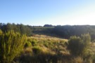
Clearings north of Mt Richardson
Photograph
•
Distance: 6.5km away
Clearings north of Mt Richardson - there's a bivvy here somewhere!
More ▶︎
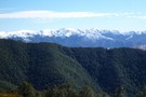
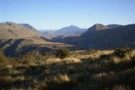
Oxford Forest
Photograph
•
Distance: 6.5km away
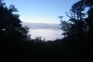
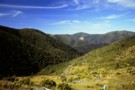
Looking northwest across Oxford Forest from a little west of Mount Oxford summit. The Wharfedale Track follows Dobson Stream left ...
More ▶︎
Mt Thomas Forest
Place
•
Reserve.
•
Distance: 6.9km away
Foothill forest northwest of Oxford and Christchurch, stretching from the Ashley Gorge to the Okuku River, and including Mount Richardson ...
More ▶︎
Pinchgut Hut via Mt Thomas, Bobs Camp Biv
Track
•
2 – 3 days. Medium. Loop track.
•
Distance: 6.9km away
Two day tramp on the ridges around Pinchgut Valley
More ▶︎

Mt Oxford Summit in October
Photograph
•
Distance: 7.0km away
Fresh snow at the Mt Oxford Summit .
More ▶︎
Summit of Mt Oxford
Photograph
•
Distance: 7.0km away
pleasant 6-7 hr return trip in Labour weekend.
More ▶︎
Mt Oxford summit
Photograph
•
Distance: 7.0km away
Mt Oxford summit panorama centered looking west.
More ▶︎
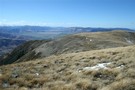
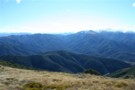
Lees Valley from Mount Oxford
Photograph
•
Distance: 7.0km away
The Lees Valley is surrounded by hills and accessed by road along the Ashley Gorge. The river here cuts through ...
More ▶︎
Hamilton Hut (Waimakariri Gorge)
Hut
•
Basic Hut/Bivvy (DOC).
•
Distance: 7.1km away
Hut on the Waimakariri Gorge near the Esk River. Part of the Oxford Forest Conservation Area.
More ▶︎
To Puketeraki Biv and back (again on Labour Weekend) 2018
Article
•
Distance: 7.5km away
3 day return trip up to Black Hill hut, down to Salmon Ck Biv then over to Puketeraki Biv via ...
More ▶︎
Puketeraki Bivvy
Hut
•
Basic Hut/Bivvy (DOC). Capacity: 2.
•
Distance: 7.6km away
Small hut with wooden platform bunks on pastoral lease land near the Waimakariri River. Craig Benbow has renovated it, lining ...
More ▶︎
Burnt forest, Mount Richardson
Photograph
•
Distance: 7.8km away
Looking northeast along Blowhard Stream.
More ▶︎
Blowhard Track
Track
•
Easy/medium. One way.
•
Distance: 8.4km away
Alternative route to the summit of Mount Richardson (1047m) in the Canterbury foothills.
More ▶︎
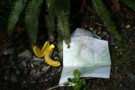
Banana Guard
Photograph
•
Distance: 8.5km away
Essential accessory for the day walk. At the top of Ryde Falls, Oxford Forest.
More ▶︎
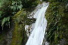
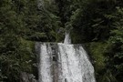
Ryde Falls
Photograph
•
Distance: 8.5km away
The third and fourth tiers of the five-tier falls in Oxford Forest.
More ▶︎
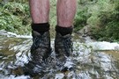
My boots
Photograph
•
Distance: 8.5km away
My Meindls, soft as clouds, and damp as clouds, on the Ryde Falls.
More ▶︎
Ryde Falls
Track
•
Easy. Return by the same track.
•
Distance: 8.5km away
Pleasant walk through beech forest to pretty falls.
More ▶︎
Ryde Falls from Coopers Creek
Track
•
Easy. Return via same track.
•
Distance: 8.5km away
Easy forest walk to a pretty waterfall with a nearby campsite.
More ▶︎
Ryde Falls
Photograph
•
Distance: 8.5km away
This pretty waterfall in Oxford Forest has seven separate steps.
More ▶︎
Mount Richardson Bypass Track
GPX file
•
Distance: 8.7km away
This track pairs with the Mount Richardson Track to form a nice loop from Glentui Bush.
More ▶︎
Mount Richardson Bypass Track
Track
•
1 day. Easy/medium. Return by the same track.
•
Distance: 8.7km away
This track drops from the ridge east of Mount Richardson to the Glentui Bush car park.
More ▶︎
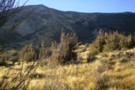
Bold Hill
Photograph
•
Distance: 8.8km away
Looking at the North face of Bold Hill from the terraces above Broken River.
More ▶︎
Craigieburn Valley
Photograph
•
Distance: 8.8km away
View North from the terrace above Avoca homestead
More ▶︎
Korowai/Torlesse Tussocklands Park
Place
•
Conservation Park. 210.00km2.
•
Distance: 8.8km away
This park incorporates the Torlesse and Big Ben Ranges either side of Porter's Pass. The Torlesse Gap is a prominent ...
More ▶︎
Ashley Gorge Loop Track
GPX file
•
Distance: 8.9km away
Short walk near the Ashley Gorge Camping Ground.
More ▶︎
Ashley Gorge Loop Track
Track
•
1 day. Easy. Loop track.
•
Distance: 8.9km away
Short family walk near Ashley Gorge Holiday Park.
More ▶︎
Avoca Homestead
Hut
•
Standard Hut (DOC). Capacity: 6.
•
Distance: 8.9km away
This hut is the restored homestead of the Avoca Run, at the junction of Broken River and Slovens Stream (not ...
More ▶︎
Ashley Gorge Waterfall Track
GPX file
•
Distance: 8.9km away
Extension to the loop track, leading up to a 10m waterfall on a local unnamed creek.
More ▶︎
Ashley Gorge Waterfall Track
Track
•
1 day. Easy. Return by the same track.
•
Distance: 8.9km away
This popular extension to the Ashley Gorge Loop Track leads to a 10-metre waterfall.
More ▶︎
Youngman Stream Track
GPX file
•
Distance: 9.0km away
Valley walk up to Youngman Stream Hut.
More ▶︎
Youngman Stream Track
Track
•
1 day. Easy/medium. Return by the same track.
•
Distance: 9.0km away
Steady sidle up the Rakahuri / Ashley River from the Lees Valley to Youngman Stream Hut.
More ▶︎
Wharfedale Hut
Hut
•
Standard Hut (DOC). Capacity: 8.
•
Distance: 9.2km away
A comfortable hut situated on the Wharfedale track. Has a wood stove with wood provided in shed at back. Stream ...
More ▶︎
Wharfedale Shelter
Photograph
•
Distance: 9.2km away
A photo showing the newly painted Wharfedale Shelter
More ▶︎
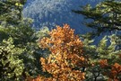
Horopito, Oxford Forest
Photograph
•
Distance: 9.5km away
This tree turns a vivid red when exposed to frosts.
More ▶︎