Nearby
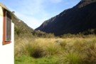
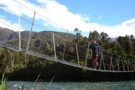
Hokitika Gorge
Hokitika River (Bottom Gorge)
Photograph
•
Distance: 134m away
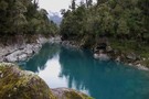
This photo looks upstream from 5 minutes above the swingbridge at the Hokitika Gorge. (The furthest downstream & closest to ...
More ▶︎
Whitcombe Pass
Track
•
5 – 7 days. Medium/hard. One way.
•
Distance: 1.5km away
This route follows the famous journey by John Henry Whitcombe and the Swiss guide Jakob Lauper across the Main Divide ...
More ▶︎
Toaroaha Saddle-Frew Saddle Circuit
Track
•
4 – 6 days. Medium. One way.
•
Distance: 1.6km away
A great tramp in a remote location, crosses two alpine saddles, ice-axes and crampons needed in winter. More information on ...
More ▶︎
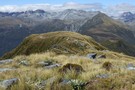
Mt Misery & beyond February 2013
Photograph
•
Distance: 2.5km away
Last month I decided to climb a hill that can be seen from home that I'd never got around to ...
More ▶︎
Whitcombe Pass & Butler Saddle
Article
•
Distance: 5.0km away
route guide attached by for Hokitika Gorge to Erewhon via Whitcombe Pass & Butler Saddle. The guide was written by ...
More ▶︎
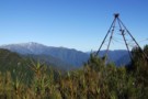
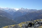
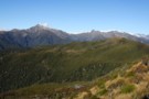
Looking SW from Mt Diedrichs May 2013
Photograph
•
Distance: 5.8km away
This photo taken from beside the trig beacon on the summit of Mt Diedrichs 1084m looks SW over the Hokitika ...
More ▶︎
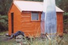
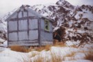
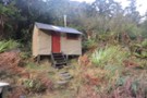
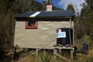
Rapid Creek hut May 1975
Photograph
•
Distance: 6.2km away
An older pic of the hut after it had got its first replacement chimney. These days the hut has a ...
More ▶︎
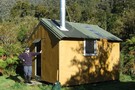
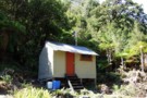
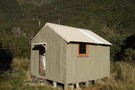
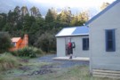
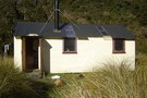
Rapid Creek hut
Hut
•
Basic Hut/Bivvy (DOC). Capacity: 4.
•
Distance: 6.2km away
This is a four bunker on the TL of the Hokitika River not far below the junction with the Whitcombe ...
More ▶︎
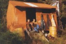
Rapid Creek hut June 2008
Photograph
•
Distance: 6.2km away
This is a four bunker on the TL of the Hokitika River not far below the junction with the Whitcombe ...
More ▶︎
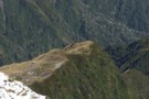
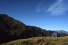
Looking down at Gerhardt Spur biv from Jumble Top May 2009
Photograph
•
Distance: 6.7km away
Gerhardt Spur biv is an early/mid 1970's era NZFS biv located in the tussock high on Gerhardt Spur which is ...
More ▶︎
"New" Gerhardt Spur biv June 1975
Photograph
•
Distance: 6.7km away
This pic shows DH at the then fairly new Gerhardt Spur biv on Queens Birthday weekend 1975. Mt Jumble Top ...
More ▶︎
Gerhardt Spur biv
Hut
•
Basic Hut/Bivvy (DOC). Capacity: 2.
•
Distance: 6.7km away
An early/mid 1970's era NZFS biv located in the tussock high on Gerhardt Spur which is on the western side ...
More ▶︎
Gerhardt Spur
Photograph
•
Distance: 6.8km away
A crystal clear morning at Gerhardt Spur Bivvy
More ▶︎
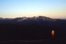
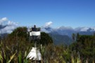
Jumbletop
Photograph
•
Distance: 7.6km away
Near the summit of Mt Jumbletop at sunrise. View to Mt Evans and Sentinal
More ▶︎
Jumble Tops Traverse
Photograph
•
Distance: 8.1km away
A GPS track of Doug Forster's traverse of Jumble Tops in pink. 3 of us did a more direct version ...
More ▶︎
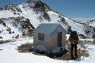
Serpentine Hut March 2015
Photograph
•
Distance: 8.2km away
Here is a recent photo of this survivor built in 1957 for deer culler accomodation. Andrew Buglass and "Permolat" helpers ...
More ▶︎
serpentine hut
Photograph
•
Distance: 8.2km away
Flew into hut to drop a group of 6 off they were going to stay the night and walk out
More ▶︎
Serpentine Hut 1977
Photograph
•
Distance: 8.3km away
This photo of Serpentine hut was taken summer time 1977 by friend & sometimes tramping companion Neil Bradley.
The access route ...
More ▶︎
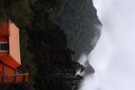
Serpentine hut setting March 2011
Photograph
•
Distance: 8.3km away
This picture from approx 300 metres away across the Hoki River shows Serpentine huts location on an overgrowing clearing on ...
More ▶︎
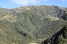
View SE along the Meta Range March 2011
Photograph
•
Distance: 8.3km away
This picture was taken from near the summit of Mt Inframeta & looks along the Meta Range toward the Southern ...
More ▶︎
Serpentine hut
Hut
•
Basic Hut/Bivvy (DOC). Capacity: 4.
•
Distance: 8.3km away
This hut is located on a small bush terrace on the TR of the Hokitika River and the TL of ...
More ▶︎
Explorer hut Sept 2007
Photograph
•
Distance: 8.5km away
Explorer hut Douglas Saddle. Mikonui River/Doctors Creek (a tributary of the Hokitika River)
More ▶︎
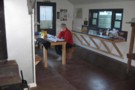
Explorer Hut
Hut
•
Basic Hut/Bivvy (DOC). Capacity: 4.
•
Distance: 8.6km away
A small hut located near Douglas Saddle.
Easiest access is from the Mikonui valley. None of the routes are recommended in ...
More ▶︎
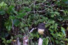
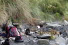
SI Bush Robin
Photograph
•
Distance: 8.6km away
This friendly bird kept me company at Explorer hut the couple of nights I was there recently. It would come ...
More ▶︎
Mt Bowen from Fraser Peak March 2013
Photograph
•
Distance: 8.6km away
This photo of Mt Bowen 1965m was taken from near the summit of Fraser Peak 1166m. Both peaks lie between ...
More ▶︎
View SE from Bald Hill Range June 2013
Photograph
•
Distance: 9.8km away
This picture was taken from the crest of the Bald Hill Range NE of Bald Hill.
The tussock and low ...
More ▶︎
Mullins Basin April 2008
Photograph
•
Distance: 9.8km away
This pic shows the huts location in the basin and shows part of the imposing Diedrich Range behind.
More ▶︎
Mullins Basin hut
Hut
•
Basic Hut/Bivvy (DOC). Capacity: 4.
•
Distance: 9.8km away
A four bunk hut situated in the head basin of Mullins Creek a TL tributary of the Toaroha River. The ...
More ▶︎
Mullins Basin hut April 2008
Photograph
•
Distance: 9.8km away
Mullins Basin hut is a four bunk hut situated in the head basin of Mullins Creek a TL tributary of ...
More ▶︎
Historic Cedar Flats Hut
Photograph
•
Distance: 10.0km away
A well maintained old hut. 2 bunks
More ▶︎
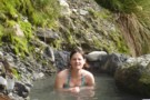
Cedar Flats Hot Springs
Photograph
•
Distance: 10.0km away
Perfect hot springs in a secluded hokitika valley. Holds upto 6 people.
More ▶︎
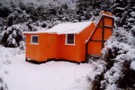
Cedar Flat Historic Hut
Photograph
•
Distance: 10.0km away
The Cedar Flat Historic hut after renovations and the picture taken during the big snow of August 2008.
More ▶︎
Cedar Flat
Track
•
2 days. Easy/medium. Return via same track.
•
Distance: 10.0km away
An easy and pleasant walk into a secluded valley near Hokitika. Rudimentary hot pools.
More ▶︎