Nearby
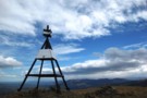
Mount Grey / Maukatere
Mt Grey - Red Beech loop 26 August 2012
GPX file
•
Distance: less than 100m away
Took me 9½ hours, did the last 2 hours after sunset. Took longer than I expected.
More ▶︎

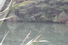
Lake Janet Frozen Over
Photograph
•
Distance: less than 100m away
Lake Janet Frozen Over rock hard
More ▶︎
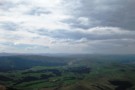
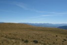
Mount Grey (lookout route)
Track
•
Easy/medium. Return via same track.
•
Distance: less than 100m away
An easy walk onto tops in the Canterbury foothills, with panoramic views of Pegasus Bay, Banks Peninsula, the Puketeraki Range, ...
More ▶︎
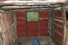
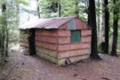
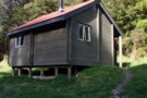
Possumer's Hut (derelict)
Hut
•
Basic Hut/Bivvy (DOC).
•
Distance: 104m away
An interesting old hut, but not very welcoming, with a dirt floor and shade cloth over the one window.
More ▶︎
Grey River Campsite
Campsite
•
Informal campsite (DOC). 10 spaces.
•
Distance: 107m away
Basic camping in a pocket of native forest next to the Grey River. A loop track leads to the Mount ...
More ▶︎
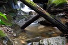
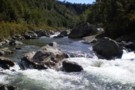
Mt Grey creek
Photograph
•
Distance: 356m away
Used a rope around a large tree to descend to the creek and set up my tripod to take a ...
More ▶︎
Okuku River - Pinchgut - Bob's Camp Bivvy - Mt Thomas
Track
•
1 – 2 days. Easy. One way.
•
Distance: 10.0km away
Nice overnighter with an easy to follow track. Possible to do in a long day if that's your thing.
More ▶︎