Nearby
Burn Creek Hut
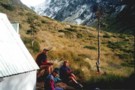
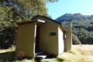
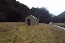
Burn Ck Bivvy
Photograph
•
Distance: less than 100m away
A basic 2 bunk bivvy that has seen better days.
Burn ck is fairly tight and gorgey with plenty of sidling ...
More ▶︎
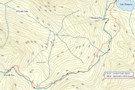
Lake Daniels to Lake Rotoroa
GPX file
•
Distance: 6.0km away
Route tracing of Alternate route from the Lewis Pass to St Arnaud
More ▶︎
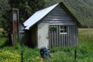
Downie Hut
Hut
•
Basic Hut/Bivvy (DOC). Capacity: 4.
•
Distance: 6.3km away
Downie Hut is an old board and batten hut with a large open fire place. The original shingle roof now ...
More ▶︎
Downies Hut
Hut
•
Basic Hut/Bivvy (DOC). Capacity: 4.
•
Distance: 6.6km away
Historic hut on the Matakitaki River, dating back to 1902 or earlier. The hut is perhaps the second oldest in ...
More ▶︎
Nardoo Hut
Hut
•
Basic Hut/Bivvy (DOC). Capacity: 2.
•
Distance: 6.8km away
Hut above the bushline on the tops between the Glenroy and Matakitaki Rivers.
More ▶︎

Blue Lake Hut - Bobs Hut
GPX file
•
Distance: 8.0km away
Blue Lake campsite to Bob’s Hut, via Lake Thompson and D’Urville Pass
An actual, recorded, gpx – the high route section ...
More ▶︎
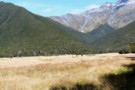
Bob's Hut
Photograph
•
Distance: 8.0km away
First view of Bob's Hut across the grassy flat (in the middle of the photo at the treeline - it ...
More ▶︎
St Arnaud - Lewis Pass
Article
•
Distance: 8.1km away
A 9-day 100km tramp via the Thompson, D'Urville and 3 Tarns Passes
Feb 2013
More ▶︎

Profile : St Arnaud - Lewis Pass
Photograph
•
Distance: 8.1km away
A useful profile of the 100km tramp - with a couple of bad weather alternatives :
1. low route past Speargrass ...
More ▶︎

Route Guide: St Arnaud to Lewis Pass
Article
•
Distance: 8.2km away
A 5-7 day north-south route from St Arnaud to the Lewis Pass, via Travers Pass, Waiau Pass, Thompson Pass and ...
More ▶︎
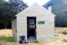
Bob's Hut
Hut
•
Standard Hut (DOC). Capacity: 8.
•
Distance: 8.2km away
Bob was to be absent when I arrived - though a cross outside hints at possible reasons. Hut book entries ...
More ▶︎
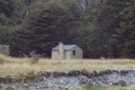
Bob's Hut
Photograph
•
Distance: 8.2km away
Bob's Hut, located in wide valley flats on the west branch of the Matakitaki River.
More ▶︎

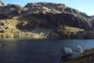
Lake Thompson
Photograph
•
Distance: 8.2km away
A view of the beautiful Lake Thompson, a short distance from Thompson Pass
More ▶︎
Picton to Aspiring
GPX file
•
Distance: 8.2km away
An aborted alpine traverse. Picton to West Cape, but aborted at Aspiring due to real world emergencies back home. Posted ...
More ▶︎
St Arnaud to Lewis Pass
Track
•
5 – 9 days. Medium/hard. One way.
•
Distance: 9.5km away
A 5-9 day north-south route from St Arnaud to the Lewis Pass, via Travers Pass, Waiau Pass, Thompson Pass and ...
More ▶︎
Thompson Pass
GPX file
•
Distance: 9.9km away
Caroline Creek Hut, Upper Waiau Valley to East Matakitaki Hut via Thompson Pass & Unamed Pass
More ▶︎
Thompson Pass
GPX file
•
Distance: 9.9km away
Caroline Creek Hut, Upper Waiau Valley to East Matakitaki Hut via Thompson Pass & Unamed Pass
More ▶︎
East Matakitaki Hut
Photograph
•
Distance: 9.9km away
beside the river and at the southern end of the flats, we found this 6-berth hut in great condition
Feb 2013
More ▶︎
East Matakitaki Hut
Photograph
•
Distance: 9.9km away
East Matakitaki Hut in the east branch of the Matakitaki Valley.
More ▶︎
East Matakitaki Hut
Hut
•
Standard Hut (DOC). Capacity: 6.
•
Distance: 9.9km away
East Matakitaki Hut (6 bunk, matresses, fireplace, creek water) lies on river flats in the upper Matakitaki valley (east branch). ...
More ▶︎