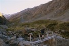
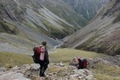
Nearby
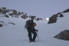
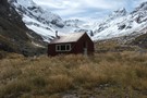
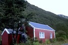
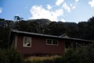
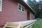
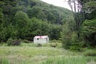
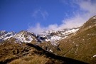
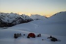
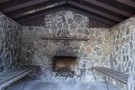
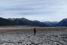
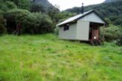
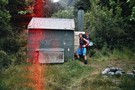
Crow hut (Arthurs Pass) March 2008
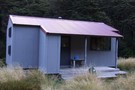
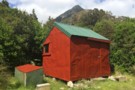
Crow Hut (Arthur's Pass)
Hut
•
Standard Hut (DOC). Capacity: 10.
•
Distance: less than 100m away
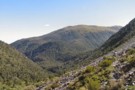
In the Crow valley, Arthur's Pass National Park.
More ▶︎
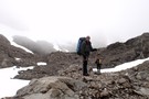
Mt Bealey - Lyell Peak - Avalanche Peak Traverse
Track
•
1 day. Medium. Loop track.
•
Distance: 1.6km away
A classic traverse from Mt Bealey to Avalanche Peak
More ▶︎
Rome Ridge - Avalanche Peak Traverse
Track
•
1 day. Medium. Loop track with a road section.
•
Distance: 1.6km away
Climb up Rome Ridge towards Mount Rolleston to traverse the ridge between it and Avalanche Peak.
More ▶︎
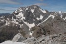
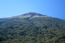
Avalanche Peak
Track
•
Medium. Loop track.
•
Distance: 1.6km away
A day trip near Arthur's Pass village to an altitude of 1833m.
More ▶︎
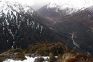
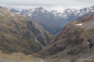
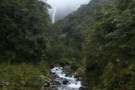
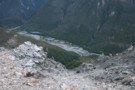
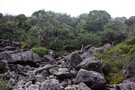
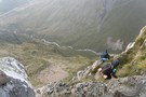
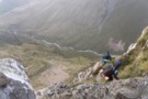
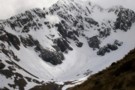
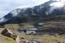
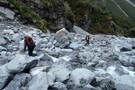
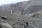
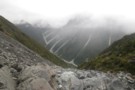
Crow Slide in snow
Photograph
•
Distance: 1.6km away
Frank and me doing an alpine finish (our speciality) down the Crow slide en route to Crow Hut from Avalanche ...
More ▶︎
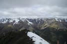
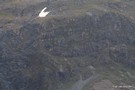
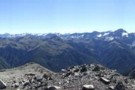
View from Avalanche Peak June 2013
Photograph
•
Distance: 1.6km away
This pic looks WSW from the summit over the Crow River to Jellicoe Ridge and beyond. The prominent summit on ...
More ▶︎
Mt Rolleston- Low Peak (via Rome ridge)
Track
•
Medium/hard.
•
Distance: 2.7km away
Track starts off at SH73 (Coral track). Steep ascent through the bush line on a marked track leading you up ...
More ▶︎
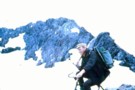
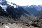
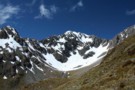
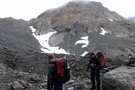
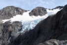
Crow Glacier, Mt Rolleston
Photograph
•
Distance: 3.4km away
Crow glacier and Mt Rolleston. taken April 1969.
More ▶︎
Millennium Walk
GPX file
•
Distance: 3.6km away
Short walk to a waterfall at the Arthur's Pass Visitor Centre.
More ▶︎
Devil's Punchbowl Track
GPX file
•
Distance: 3.7km away
Short walk to a classic Arthur's Pass waterfall.
More ▶︎
Walks Around Arthur's Pass
Article
•
Distance: 3.7km away
A variety of both easy and more challenging walks are available around Arthur's Pass village and the nearby pass.
More ▶︎
Avalanche Creek Shelter campsite
Campsite
•
Basic Campsite (DOC). 10 spaces.
•
Distance: 3.7km away
Campsite located near the highway in Arthur's Pass Village. A good base for a variety of day walks. The information ...
More ▶︎
Waimakariri Falls Hut
Hut
•
Basic Hut/Bivvy (Canterbury Mountaineering Club). Capacity: 6.
•
Distance: 3.8km away
Located in the Waimakariri headwaters at 1300m, just above the top falls. Built 1960, and refurbished 2005.
More ▶︎
Mt Rolleston - Otira Face
Photograph
•
Distance: 3.8km away
The best known peak in Arthurs Pass national park. The Otira Face as seen here from Mt Philistine is often ...
More ▶︎
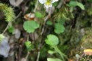
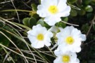
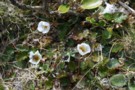
Mountain violet
Photograph
•
Distance: 3.9km away
Viola cunninghamii, Bridal Veil Track, Arthur's Pass.
More ▶︎
Mt Bealey
Video
•
Distance: 3.9km away
A handy winter day trip from Greymouth view at:
http://www.youtube.com/watch?v=sEhVTeoq9-k
More ▶︎
Above Waimakariri Falls
Photograph
•
Distance: 3.9km away
Looking down the valley from high under Waimak Col. Spot the hut? (just left of the river - the new ...
More ▶︎
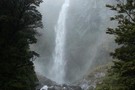
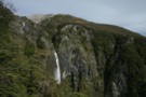
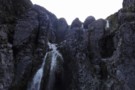
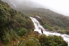
Devil's Punchbowl Walking Track
Track
•
Easy/medium. Return by the same track.
•
Distance: 4.1km away
Classic Arthur's Pass walk to the 131m Punchbowl Falls / Te Tautea o Hinekakai.
More ▶︎
Arthur's Pass Village Historic Walk
Track
•
Easy. Loop track.
•
Distance: 4.1km away
Introductory circuit of the village, providing a history of the Pass and the rail tunnel.
More ▶︎
Avalanche Peak-Crow River
Track
•
1 – 2 days. Medium. One way.
•
Distance: 4.1km away
A route over Avalanche Peak dropping to the Crow River and exiting down the Waimakariri River.
More ▶︎

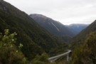
Arthur's Pass National Park
Place
•
National Park. 1145.00km2.
•
Distance: 4.1km away
This alpine park straddles the Main Divide of the Southern Alps, with dry beech forests in the east and damp ...
More ▶︎
Arthur's Pass Village
Place
•
Place.
•
Distance: 4.1km away
Resort village surrounded by mountains within Arthur's Pass National Park.
More ▶︎

Te Araroa Trail
Track
•
95 days. Medium. One way.
•
Distance: 4.1km away
Te Araroa is a walking trail running the entire length of the North and South Islands. The trail opened 3 ...
More ▶︎
Arthur's Pass Walking Track
Track
•
Easy. One way.
•
Distance: 4.1km away
A new walk, opened March 2014 to mark 150 years of Arthur's Pass. Attractive and easy walking from the Arthur's ...
More ▶︎
Mount Cassidy
Track
•
1 day. Medium/hard. Return via same track.
•
Distance: 4.4km away
A short but challenging climb from Arthur's Pass Village.
More ▶︎
Bealey Chasm and Valley
Track
•
Easy/medium.
•
Distance: 4.5km away
A excellent short walk in the autumn or spring with wonderful views of rolleston glacier
More ▶︎
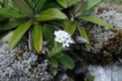
Great mountain buttercup
Photograph
•
Distance: 4.6km away
Ranunculus lyalli. Con's Track, Mount Cassidy, Arthur's Pass.
More ▶︎
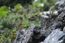
Rock wren
Photograph
•
Distance: 4.6km away
I heard this bird before I saw it, on the scree just above the Con's Track bushline on Mount Cassidy, ...
More ▶︎
Dobson Nature Walk
GPX file
•
Distance: 4.9km away
Stroll through an alpine herbfield scattered with massive boulders, Arthur's Pass National Park.
More ▶︎
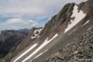
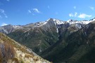
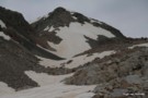
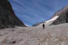
Head of the Rolleston River, just below Pt2000
Photograph
•
Distance: 4.9km away
Taken while traversing slopes high in the Rolleston river. Shows the snow slope used to access the first col north ...
More ▶︎
Dobson Nature Walk
Track
•
Easy. One way.
•
Distance: 4.9km away
A short walk on the Main Divide of the Southern Alps, offering alpine flora and panoramic views.
More ▶︎
Lake Misery Track
GPX file
•
Distance: 5.2km away
Short connector track that crosses the Main Divide of the Southern Alps.
More ▶︎
Shattered rock on Mount Cassidy
Photograph
•
Distance: 5.4km away
The rock is very crumbly and unstable.
More ▶︎
Otira Valley
Track
•
Easy. Return via same track.
•
Distance: 5.6km away
A short, pretty walk into an alpine environment. A variety of alpine flowers in summer.
More ▶︎
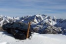
Carrington Peak
Photograph
•
Distance: 5.7km away
Carrington Peak, Arthur's Pass, from near Carrington hut. taken February 2007
More ▶︎
Carrington Hut
Photograph
•
Distance: 5.9km away
A large wooden hut at the confluence of the Waimakariri and the White Rivers.
More ▶︎
Lake Misery Track
Photograph
•
Distance: 5.9km away
Small rockpile on the Lake Misery Track.
More ▶︎
Mt Philistine Traverse
Track
•
1 day. Hard. One way.
•
Distance: 6.0km away
A classic mountain traverse in Arthurs Pass National Park, includes climbing steep scree, bluffs, rock and snow. An ice axe ...
More ▶︎
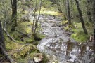
Other Part of trail to Carrington Hut
Photograph
•
Distance: 6.1km away
the trail after a nice rain
More ▶︎
Harman Pass - Taipo River - Kelly Saddle
Track
•
3 – 5 days. Medium/hard. One way.
•
Distance: 6.1km away
A long journey through the west of Arthur's Pass National Park.
More ▶︎
Carrington Hut
Hut
•
Serviced Hut (DOC). Capacity: 36.
•
Distance: 6.1km away
A large hut in the upper Waimakariri River, and often the first or last hut on a longer trip.
The extensive ...
More ▶︎
Barker Hut
Track
•
2 – 3 days. Medium. Return by the same track.
•
Distance: 6.1km away
Surrounded by glaciers at the head of the White River, this is the highest hut in Arthur's Pass National Park.
More ▶︎
Philistine / Warnock's Bluffs
Photograph
•
Distance: 6.2km away
The normal route up Philistine from the road ascends through this line of bluffs. When there is no snow, the ...
More ▶︎
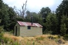
Anti Crow Hut
Hut
•
Standard Hut (DOC). Capacity: 6.
•
Distance: 6.3km away
In the Waimakariri valley near Anti Crow River.
The previous Anti Crow Hut used to be the CMC hut about half ...
More ▶︎
Philistine Bluffs
Photograph
•
Distance: 6.4km away
Decending the bluffs - not a forgiving place to loose your footing- there have been deaths here.
More ▶︎
Mt Philistine
Track
•
1 day. Medium/hard. Return via same track.
•
Distance: 6.4km away
Moderate to hard daytrip in Arthurs Pass.
More ▶︎
Philistine Bluffs
Photograph
•
Distance: 6.4km away
Decending the bluffs - not a forgiving place to loose your footing- there have been deaths here.
More ▶︎
Temple Basin
Track
•
Easy/medium. Return via same track.
•
Distance: 6.5km away
A steepish climb through alpine meadows to the Temple Basin skifield
More ▶︎
Temple Basin Ski Field
Photograph
•
Distance: 6.5km away
Taken a little past the ski huts, November 2012
More ▶︎
Mt Aicken in Jan
Photograph
•
Distance: 6.8km away
Require Medium fitness level, rock/stone marked track above bushline.
More ▶︎
Lake Mavis
Track
•
2 days. Medium. Return via same track.
•
Distance: 6.9km away
A side trip off the popular Mingha-Deception route in Arthur's Pass.
More ▶︎
Mount Barron
Photograph
•
Distance: 6.9km away
Mount Barron from the Death's Corner lookout. The route follows the far edge of the obvious slip. The steep bluffs ...
More ▶︎
Page Memorial Shelter
Photograph
•
Distance: 7.0km away
Day shelter in Temple Basin, Arthurs Pass.
Page Memorial Shelter is little day-hut built for skiers in Temple Basin, set apart ...
More ▶︎

Edwards River-Hawdon River
Track
•
3 days. Medium. One way.
•
Distance: 7.2km away
See Hawdon River.
More ▶︎
Greyneys campsite
Campsite
•
Informal campsite (DOC). 10 spaces.
•
Distance: 7.3km away
A grassy clearing in the forest next to the highway, with a stone shelter. This campsite is located near the ...
More ▶︎
Taipoiti Gorge
Photograph
•
Distance: 7.5km away
Described in DoC literature as "impassable", small waterfalls at the top of the Taipoiti Stream, on the way from Carrington ...
More ▶︎
Greyneys Shelter June 2012
Photograph
•
Distance: 7.5km away
This shelter is next to SH 73 between Arthur's Pass Village and the Waimakariri River at Klondyke Corner. It's handy ...
More ▶︎
Mingha River-Deception River
Track
•
2 days. Medium. One way.
•
Distance: 7.7km away
Goat Pass Track. Alpine track over a pass between two river valleys.
More ▶︎
Harman Pass
Photograph
•
Distance: 8.2km away
Looking back over Ariels Tarns to Harman Pass.
More ▶︎
The Trail Klondyke Corner to Carrington Hu
Photograph
•
Distance: 8.6km away
view of the grassy trail before the riverbed becomes the trail.
The hut is still far here but it is behind ...
More ▶︎
Waimakariri River-Rolleston River
Track
•
2 – 3 days. Hard. One way.
•
Distance: 8.6km away
Alpine tramp over Waimakariri Col.
More ▶︎
The Track Starts
Photograph
•
Distance: 8.6km away
After three or four scree/shrub combinations, where the gorge below opens out a little, keep an eye out for the ...
More ▶︎
Track Descent
Photograph
•
Distance: 8.6km away
The map shows the track crossing two small tributaries before heading sharply down to meet the main river. You may ...
More ▶︎
Pick Your Path
Photograph
•
Distance: 8.6km away
Try to stay reasonably high above the river on the true left for the easiest route down and to avoid ...
More ▶︎
Grass my Arse
Photograph
•
Distance: 8.6km away
Sections of alpine "herbs" break up the scree slopes high above the Rolleston River. There is no track through these ...
More ▶︎
At the top
Photograph
•
Distance: 8.6km away
If intending to cross over into the Rolleston from the Waimak, DON'T go over the actual Waimak Col (you'll see ...
More ▶︎
Top of Rolleston Valley
Photograph
•
Distance: 8.6km away
There are sporadic cairns down into the Rolleston Valley, but they can be difficult to pick out against the scree. ...
More ▶︎
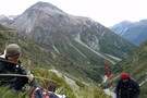
Route Planning
Photograph
•
Distance: 8.6km away
Checking the map for a route over the head of the Waimakariri Valley into the Rolleston Valley. Be aware in ...
More ▶︎
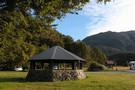
Klondyke Corner campsite
Campsite
•
Informal campsite (DOC). 30 spaces.
•
Distance: 8.8km away
A large grassy site often used as a base for trampers in the area. The area features a striking octagonal ...
More ▶︎
Klondyke shelter and campsite
Photograph
•
Distance: 8.8km away
The striking octagonal shelter by the roadside, and camping area beyond.
More ▶︎
Three Passes
Track
•
4 – 5 days. Medium/hard. One way.
•
Distance: 9.0km away
A classic trip from Arthur's Pass across Browning, Whitehorn and Harman Passes, emerging near Lake Kaniere on the West Coast.
More ▶︎
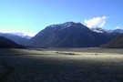
Waimakariri River flats
Photograph
•
Distance: 9.0km away
Starting out from the East Coast, the Waimakariri River is a long but easy slog to Carrington Hut. Follow the ...
More ▶︎
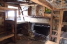
inside old julia
Photograph
•
Distance: 9.0km away
a classic view of the interior of a classic hut. Note the hand hewn locally sourced timbers.
More ▶︎
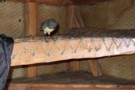
SI Bush Robin in Old Julia hut April 2013
Photograph
•
Distance: 9.0km away
For the second time in about a month a bush robin has spent time in a hut that I've been ...
More ▶︎
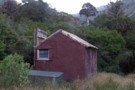
"Old" Julia hut
Hut
•
Basic Hut/Bivvy (DOC). Capacity: 4.
•
Distance: 9.0km away
Close to the "New" Julia hut near the confluence of Julia & Mary Creeks where they join to form the ...
More ▶︎
"Old" Julia hut Feb 2009
Photograph
•
Distance: 9.0km away
Close to the "New" Julia hut near the confluence of Julia & Mary Creeks where they join to form the ...
More ▶︎
Julia Hut
Photograph
•
Distance: 9.2km away
Standard DOC hut at the confluence of the Julia & Taipo rivers.
More ▶︎
Julia Hut
Hut
•
Standard Hut (DOC). Capacity: 6.
•
Distance: 9.2km away
Standard DOC hut at the confluence of Julia and Mary Creeks where they meet the Taipo River. Good hot pools ...
More ▶︎
Taipo River track to Julia Hut
Photograph
•
Distance: 9.3km away
Taipo River track to Julia Hut - above Dry Creek
More ▶︎
Ascending Whitehorn Snowfield
Photograph
•
Distance: 9.5km away
Only old icy snow on the field in summer. Ice axe recommended for this part, but if confident on ice ...
More ▶︎
Dry Creek
Photograph
•
Distance: 9.5km away
Dry Creek - descending into the Taipo from it's 1700m saddle off Hunts Creek
More ▶︎
Mingha Biv
Photograph
•
Distance: 9.5km away
The old and not in very good condition Mingha Biv
More ▶︎
Mingha Biv
Hut
•
Basic Hut/Bivvy (DOC). Capacity: 2.
•
Distance: 9.5km away
Just south of Goat Pass. Hut has had a full refurbishment thanks to NZDA, Permolat and The Back Country Trust. ...
More ▶︎
Kelly Tops, Dry Creek, Taipo Circuit
Article
•
Distance: 9.6km away
A 3 day circuit from 7 Mile Creek to the Kelly Tops, down to Hunts Saddle and then over Hunts ...
More ▶︎
Cronin Icefall
Photograph
•
Distance: 9.8km away
Seen from Whitehorn Pass, the spectacular icefall coming off the Cronin Glacier. Whitehorn Pass is the highest point on the ...
More ▶︎
Old Julia Hut
Photograph
•
Distance: 10.0km away
Old Julia Hut after refurbishment in February 2014.
More ▶︎