Nearby
Hurricane Hut
Matiri Valley to Wangapeka Saddle
Track
•
4 – 6 days. Medium. One way.
•
Distance: less than 100m away
An interesting cross country trip in Kahurangi National Park involving a stretch of unmarked ridge travel
More ▶︎
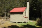
Hurricane Hut
Photograph
•
Distance: less than 100m away
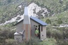
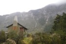
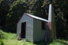
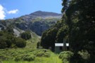
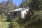
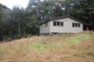
A compact little hut in the head of the Matiri Valley
More ▶︎
Hurricane Hut
Photograph
•
Distance: less than 100m away
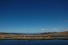
The hut can be seen from well down the flat, before you het there.
More ▶︎
Matiri Valley to Wangapeka Saddle
GPX file
•
Distance: less than 100m away
An interesting cross country trip in Kahurangi National Park
More ▶︎
Hurricane Hut
Photograph
•
Distance: less than 100m away
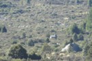
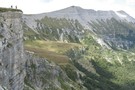
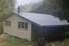
Hurricane Hut - tumbled limestone bluffs beyond
More ▶︎
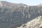
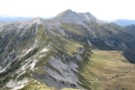
Larrikin Hut to Hurricane Hut via Mt Haystack
Photograph
•
Distance: 1.8km away
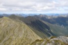
This pic is taken from point 1442 looking back towards Mt Haystack. The point on the skyline is 1411 on ...
More ▶︎
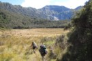
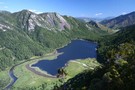
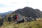
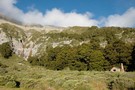
Nice clearings in the Upper Matiri
Photograph
•
Distance: 3.1km away
After a lot of bush and river travel, this clearing make a pleasant respite
More ▶︎
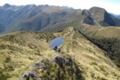
Tarn on the Matiri to Wangapeka ridge
Photograph
•
Distance: 3.4km away
This little tarn is the only water along the ridge and also makes a good camping spot if you want ...
More ▶︎
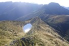
Tarn - Matiri Tops
Photograph
•
Distance: 3.4km away
Tarn, and sole campspot / water source on the Matiri Tops. 3km north of pt1442
More ▶︎
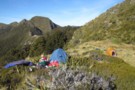
Camping by the Tarn on the Matiri Wangapeka Ridge
Photograph
•
Distance: 3.5km away
There was one established tent site and we found room for another tent.
More ▶︎
Mt Arthur to Murchison
GPX file
•
Distance: 3.6km away
track from Mt Atrhur Tablelands to Murchison via Wangapeka Saddle, Nugget Knob and the Matiri Valley
More ▶︎
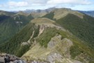
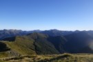
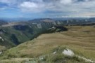
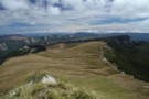
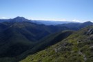
Patches of bush on Matiri Range Dec 2017
Photograph
•
Distance: 3.6km away
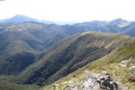
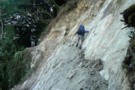
This view shows the landscape of the Matiri Range and looks SW from near Point 1393m. You need to cross ...
More ▶︎
1000 Acre Plateau
GPX file
•
Distance: 7.8km away
The route from The Matiri Road end up to the Plateau, Larrikins Hut and on to climb the Needle
More ▶︎
Nuggett Knob Close up
Photograph
•
Distance: 7.8km away
Only one more hill to go over before the Wangapeka
More ▶︎
Mt Haystack from the Needle
Photograph
•
Distance: 7.9km away
The Needle-Haystack ridge looks quite a daunting prospect. The key is to regain the ridge top as quick as possible ...
More ▶︎
Panorama from the Needle
Photograph
•
Distance: 7.9km away
Haystack, Larrikin Creek, 100 Acres Plateau.
More ▶︎
Thousand Acres Plateau
Track
•
3 – 4 days. Medium. Return via same track.
•
Distance: 7.9km away
Explore a cliff-edged tussock plateau near Murchison.
More ▶︎
Larrikin's Creek Hut
Photograph
•
Distance: 8.1km away
This is a great hut, fireplace, 4 bunks and serviced by DOC. I recommend a partner and a bottle of ...
More ▶︎
Larrikin Creek Hut
Photograph
•
Distance: 8.1km away
A small but tidy hut near the Hundred Acres Plateau.
More ▶︎
Larrikin Creek Hut
Hut
•
Standard Hut (DOC). Capacity: 4.
•
Distance: 8.1km away
A tidy hut located in forest margin at the foot of the Haystack, a small peak with striking mudstone banding. ...
More ▶︎
Matiri Wangapeka ridge from Nuggett Knob
Photograph
•
Distance: 8.5km away
This photo shows the whole ridge. Point 1442 above Hurricane Hut is in the middle and the tarn is on ...
More ▶︎
Wangapeka Saddle
Photograph
•
Distance: 8.5km away
Wangapeka Saddle from Nuggett Knob. Mt Luna to the right
More ▶︎
McConchies Hut
Hut
•
Standard Hut (DOC). Capacity: 4.
•
Distance: 9.1km away
Standard 4 bunk hut in the Matiri Valley, Kahurangi National Park.
More ▶︎
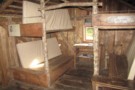
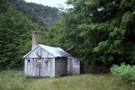
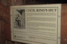
Cecil Kings Hut
Hut
•
Basic Hut/Bivvy (DOC). Capacity: 4.
•
Distance: 9.2km away
This historic hut is only a couple of hundred metres from the newer and larger Kings Creek Hut on the ...
More ▶︎
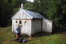
Cecil King Historic Hut
Photograph
•
Distance: 9.2km away
Built from the bush, a reminant from a past era
More ▶︎
Kings Creek Hut
Photograph
•
Distance: 9.5km away
A large and rather clinical hut on the Wangapeka Track
More ▶︎
Kings Creek Hut
Hut
•
Serviced Hut (DOC). Capacity: 20.
•
Distance: 9.5km away
A large and clinical 1980s hut on the Wangapeka Track
More ▶︎
Wangapeka Track
Track
•
4 – 5 days. Medium. One way.
•
Distance: 9.5km away
A Long gold trail following a series of river valleys.
More ▶︎
Great place for a snack
Photograph
•
Distance: 9.5km away
Doing my Garfield act on the last day of the Wangapeka
More ▶︎
Johnson hut Oct 2010
Photograph
•
Distance: 9.8km away
This is a 1957 vintage NZFS Nelson Conservancy design four bunk hut. It is located in a small clearing amongst ...
More ▶︎
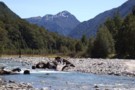
Johnson River Oct 2010
Photograph
•
Distance: 9.8km away
This pic was taken about 10 minutes above Johnson hut on the lower reaches of the Johnson River. The prominent ...
More ▶︎
Johnson hut
Hut
•
Basic Hut/Bivvy (DOC). Capacity: 4.
•
Distance: 9.8km away
This is a 1957 vintage NZFS Nelson Conservancy design four bunk hut. It is located in a small clearing amongst ...
More ▶︎
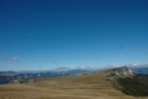
100 Acres Plateau
Photograph
•
Distance: 9.9km away
This is a beautiful tussock landscape dominated by the Needle and the Haystack. Accessed from Larrikin's Creek Hut, there are ...
More ▶︎