Nearby
Hopkins Valley
Huxley Valley
Track
•
2 days. Easy/medium. Return via same track.
•
Distance: less than 100m away
Easy walking at the head of Lake Ohau.
More ▶︎
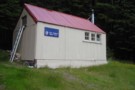
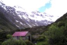
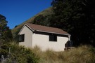
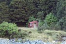
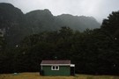
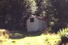
Monument Hut
Photograph
•
Distance: less than 100m away
Monument Hut, in the Hopkins - a handy evening walk in for those heading up the Hopkins or Huxley the ...
More ▶︎
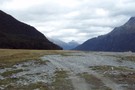
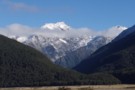
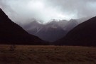
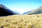
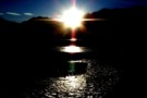
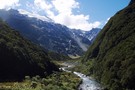
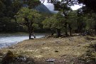
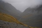
Hopkins Valley
Photograph
•
Distance: less than 100m away
The Hopkins Valley at Monument Hut
More ▶︎
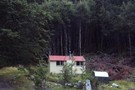
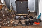
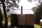
Monument Hut
Hut
•
Standard Hut (DOC). Capacity: 6.
•
Distance: less than 100m away
Monument Hut (6 bunks, matresses, stove, firewood, river water) is a forestry style hut in the Hopkins. Its located just ...
More ▶︎
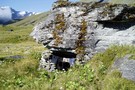
Cullers Hut
Hut
•
Standard Hut (DOC). Capacity: 4.
•
Distance: less than 100m away
possibly an old forestry hut? nice old hut to stay in the summer time, can be abit cold either side ...
More ▶︎
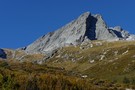
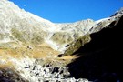
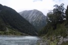
Dasler Pinnacles
Photograph
•
Distance: less than 100m away
Dasler Pinnacles (2315m) from track through scrub above Dasler Biv.
More ▶︎
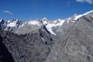
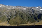
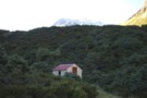
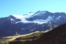
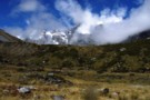
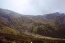
Huxley Valley, Anita Peak from Red Hut
Photograph
•
Distance: less than 100m away
Huxley Valley, Anita Peak from Red Hut in the Hopkins
More ▶︎
Ruataniwha Conservation Park
Place
•
Conservation Park. 368.00km2.
•
Distance: less than 100m away
The Ruataniwha Conservation Park occupies a mountainous landscape, and includes the valleys of the Dobson, Hopkins, Huxley, Temple and Maitland ...
More ▶︎
Dasler Pinnacles
Track
•
2 days. Medium/hard. Return via same track.
•
Distance: less than 100m away
This trail leads from the flat valley floor steeply up to Dasler Biv and beyond the the Pinnacles themselves.
More ▶︎
Red Hut
Hut
•
Standard Hut (DOC). Capacity: 12.
•
Distance: less than 100m away
Historic hut in the Hopkins Valley north of Lake Ohau. Constructed in 1916 for commercial tourism, and recently restored.
More ▶︎
Elcho Hut, Hopkins
Photograph
•
Distance: less than 100m away
Owned by the New Zealand Alpine Club. taken in jan 09.
More ▶︎
Elcho Hut
Hut
•
Standard Hut (NZAC). Capacity: 12.
•
Distance: less than 100m away
Owned by the New Zealand Alpine Club. well maintained hut with a good view up the valley and close to ...
More ▶︎
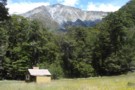
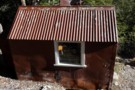
Dodger Hut
Photograph
•
Distance: less than 100m away
A quaint 4 bunk hut in a lovely setting on a grassy terrace above the Hopkins River
More ▶︎
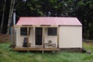
Dodger Hut
Hut
•
Standard Hut (DOC). Capacity: 4.
•
Distance: less than 100m away
Located on flats near on the Hopkins River.
More ▶︎
Erceg Hut
Hut
•
Basic Hut/Bivvy (DOC). Capacity: 4.
•
Distance: less than 100m away
Located on the Hopkins River near Richardson Glacier.
More ▶︎
Erceg Hut
Photograph
•
Distance: less than 100m away
A brilliant spot for a hut amongst a rich variety of alpine plants, well above the Upper Hopkins River with ...
More ▶︎
Picton to Aspiring
GPX file
•
Distance: 101m away
An aborted alpine traverse. Picton to West Cape, but aborted at Aspiring due to real world emergencies back home. Posted ...
More ▶︎
Richardson Rock Biv
Rock bivouac
•
Distance: 272m away
Located at the foot of Richardson Glacier on the Hopkins River. A number of rocks provide single-occupancy holes.
More ▶︎
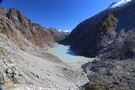
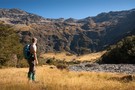
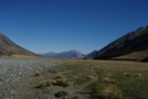
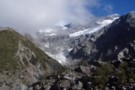
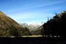
Huxley Valley
Photograph
•
Distance: 2.7km away
Huxley Valley, looking towards the Forks. Forks Hut is on flats at the base of the peak in the distance.
More ▶︎
Dasler Bivouac
Photograph
•
Distance: 3.3km away
Small hut just below bushline on track to Dasler Pinnacles.
More ▶︎
Dasler Bivouac
Hut
•
Basic Hut/Bivvy (DOC). Capacity: 2.
•
Distance: 3.3km away
Historic tin biv constructed in 1966 and located on the steep wall of the Hopkins Valley near the Dasler Pinnacles. ...
More ▶︎
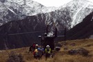
Otago rescue chopper, Huxley Valley
Photograph
•
Distance: 4.7km away
The Otago rescue chopper up the Huxley, called using an EPIRB (beacon) upon finding a party with an injured member ...
More ▶︎
Kennedy Hut
Hut
•
Standard Hut (DOC). Capacity: 6.
•
Distance: 5.3km away
Kennedy Hut / Kennedy Memorial Hut (6 bunks, matresses, stove, tank & stream water) is a spacious 6 bed hut ...
More ▶︎
Mad Pom's latest Adventure - Part 5
Article
•
Distance: 5.3km away
A trip to the head of the Landsborough - and all that ensues.
Part 5 - Heroes and Angels.
More ▶︎
Mad Pom's latest Adventure - part 4
Article
•
Distance: 5.3km away
A trip to the head of the Landsborough - and all that ensues.
Part 4: the longest walk.
More ▶︎
Mad Pom's latest adventure
Article
•
Distance: 5.3km away
A trip to the heads of the Landsborough ... and all that ensues.
More ▶︎
Mad Pom's latest adventure. Part 2
Article
•
Distance: 5.3km away
A trip to the head on the landsborough, and all that ensues. Part two.
More ▶︎
Waterfall Hut (Dobson Valley, Canterbury)
Hut
•
Standard Hut (DOC). Capacity: 4.
•
Distance: 5.4km away
Waterfall hut has washed away.
Waterfall Hut (4 bunks, matresses, fireplace, firewood available, stream water) was a forestry-style hut tucked into ...
More ▶︎
Tragedy Col
Photograph
•
Distance: 5.4km away
Tragedy Col, from Waterfall Hut in the Dobson. A hard - v. hard alpine route from the Dobson into the ...
More ▶︎
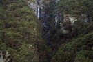
Waterfall Hut waterfall!
Photograph
•
Distance: 5.4km away
The waterfall at Waterfall Hut in the Dobson
More ▶︎
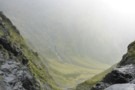
Cirque wall in Kea creek, below Elcho Pass.
Photograph
•
Distance: 5.5km away
We found a ok route along ledges to the true left of the waterfall, only had one steep drop about ...
More ▶︎
Huxley Forks Hut
Hut
•
Standard Hut (DOC). Capacity: 6.
•
Distance: 5.6km away
Huxley Forks Hut (6-bunk, matresses, stove, firewood, tank/creek water) is an old, homely forestry-style hut at the forks of the ...
More ▶︎
Gunsight Pass
Article
•
Distance: 5.8km away
With a couple of spare days in South Canterbury the forecast gale nor'westerlies and heavy rain on the main divide ...
More ▶︎
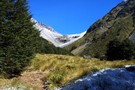
Temple Stream North Branch
Photograph
•
Distance: 5.8km away
View of the spectacular cirque at the end of Temple Stream North Branch.
More ▶︎
Temple Stream - North Branch
Track
•
1 day. Easy/medium. Return by the same track.
•
Distance: 5.9km away
North Temple Track.
Cross North Temple Stream and follow the track up North Temple valley. The track has been washed out ...
More ▶︎
South Huxley Bivvy
Hut
•
Basic Hut/Bivvy (DOC). Capacity: 2.
•
Distance: 6.2km away
Small hut on the Huxley River South Branch.
More ▶︎
Readon Hut / Reardon Hut
Hut
•
Basic Hut/Bivvy (DOC). Capacity: 2.
•
Distance: 6.7km away
Rea(r)don Hut (2 bunks, matresses, tank water, no fire) is a large bivvy / small hut near the head of ...
More ▶︎
Grough Hut
Hut
•
Basic Hut/Bivvy (DOC). Capacity: 2.
•
Distance: 6.8km away
The innacurately named Grough Hut (2 beds, 1 matress, no fire, water distant) is actually a very basic bivvy on ...
More ▶︎
Readon Hut
Photograph
•
Distance: 6.8km away
Readon Hut, in the upper Dobson., Despite being only 8km from Mt Cook Village, this hut is most commonly accessed ...
More ▶︎
Halfway up to Gunsight Pass
Photograph
•
Distance: 7.0km away
Climbing up the gut from Temple Stream North Branch to Gunsight Pass. Looking back to the cirque at the head ...
More ▶︎
Le Crens Hut / L. A. Crens Hut
Hut
•
Private hut (PVT). Capacity: 4.
•
Distance: 7.3km away
L.A. Crens Hut (private?, 4 bunk, fireplace, stream water) is a historic station hut on Glen Lyon Station land in ...
More ▶︎
Hopkins/Dobson confluence
Photograph
•
Distance: 7.7km away
Hopkins and Dobson Valley, from Huxley Lodge. Note that Huxley Lodge (at the roadend) is a private school lodge. The ...
More ▶︎
Lower Dobson Valley
Photograph
•
Distance: 8.3km away
Lower Dobson Valley between Grough Hut and Le Crens Hut
More ▶︎
Mount Hopkins
Photograph
•
Distance: 8.3km away
Mount Hopkins, in the upper Dobson. Readon hut lies on the valley floor, to the left of the peak.
More ▶︎
Zora Canyon
Photograph
•
Distance: 8.4km away
Zora Canyon in the Landsborough. This creek leads to a low pass into the Mahitahi, but looked unnavigable in the ...
More ▶︎
Huxley North Branch
Photograph
•
Distance: 8.5km away
The North Branch of the Huxley towards Brodrick Hut and Mt Strauchon
More ▶︎
Rubicon Flats and Mt Barnes, Landsborough
Photograph
•
Distance: 8.6km away
Rubicon Flats and Mt Barnes, Landsborough. Supposedly there's a rock biv on top of the grassed over lateral moraine in ...
More ▶︎
Rubicon Rock Biv
Rock bivouac
•
Distance: 8.8km away
Located on a terrace above the fork of Rubicon Torrent with the Landsborough River. The biv has been enclosed by ...
More ▶︎
Rubicon Biv
Hut
•
Shelter (DOC). Capacity: 2.
•
Distance: 8.8km away
A neat natural rock bivouac located on the northern terraces of Rubicon Torrent in the upper Lansborough. Water is only ...
More ▶︎
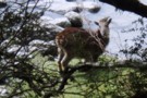
Tahr in the Landsborough
Photograph
•
Distance: 8.9km away
Tahr in the Landsborough. Seems strange to see them on the valley floor in mid summer: maybe travelling or maybe ...
More ▶︎
Brodrick Hut
Hut
•
Standard Hut (DOC). Capacity: 6.
•
Distance: 8.9km away
Brodrick Hut (sleeps 6, tank water, stove, firewood available) is a 1960's forestry hut at the base of the Brodrick ...
More ▶︎
McKerrow Creek camp spots
Photograph
•
Distance: 9.2km away
Typical of camp spots beside most side creeks up the Landsborough. With only 2 huts, this is canvas country - ...
More ▶︎
South Temple Hut
Track
•
1 – 2 days. Easy/medium. Return by the same track.
•
Distance: 9.2km away
Beech forest walk at the head of Lake Ohau. This Track is best done as an overnight walk with a ...
More ▶︎
Temple View
Track
•
Easy/medium. Return via same track.
•
Distance: 9.2km away
The Temple Valley is headed by a ring of handsome mountains. This walk explores the lower section of the valley, ...
More ▶︎
Temple Shelter
Hut
•
Shelter (DOC).
•
Distance: 9.3km away
Temple Shelter is a three-and-a-half walled shelter at the DOC campground at the Temple Stream roadend. The shelter has a ...
More ▶︎
A Temple - Maitland Circuit: the perils and joys of tramping in company
Article
•
Distance: 9.3km away
or ... 'He took me tramping and I cried'
Taking others tramping is for me, always an exercise fraught with doubt. ...
More ▶︎
Temple Valleys Circuit
Track
•
2 – 3 days. Medium. Loop track.
•
Distance: 9.4km away
Tramping the North and South Temple Valleys connecting the two over Gunsight Pass.
More ▶︎
MacKenzie Creek from Brodrick Pass
Photograph
•
Distance: 9.6km away
MacKenzie creek descends towards the Landsborough from Brodrick pass. This hanging valley drops vertically from the limit of this photo ...
More ▶︎
Brodrick Pass
Photograph
•
Distance: 9.6km away
Brodrick Pass from Brodrick Hut, an easy low route into the mid-reaches of the Landsbrorough from the Nth Hxley
More ▶︎
South Temple
Photograph
•
Distance: 9.7km away
The South Temple valley, looking towards the forks 2km below Sth Temple Hut (hut is up the main valley to ...
More ▶︎
Barron Saddle Hut
Hut
•
Serviced Alpine Hut (DOC). Capacity: 8.
•
Distance: 9.8km away
An iron cylinder near Barron Saddle.
More ▶︎