Nearby
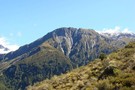
Dragonfly slopes
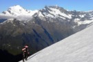
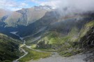
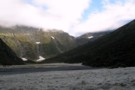
Approaching the South AlbertBurn saddle and the sun
Photograph
•
Distance: 983m away
An early start made it easier to cross the slopes above Hester Pinney Ck. We were pleased to make it ...
More ▶︎
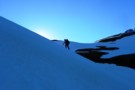
A visit to South AlbertBurn saddle
Photograph
•
Distance: 1.1km away
Michael crosses the snow slopes above Hester Pinney Creek. The sun has only just risen over the saddle and the ...
More ▶︎
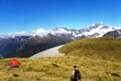
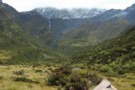
A camp with a view over the East Matukituki
Photograph
•
Distance: 1.6km away
Kathryn returns from Dragonfly Peak to her camp on the ridge to South AlbertBurn saddle from the East Matukituki.
More ▶︎

Haast to The Divide
GPX file
•
Distance: 2.8km away
Andrew Barker's traverse 2009. From Pleasant Flat in the Haast to The Divide via Mt Aspiring National Park.
More ▶︎
Picton to Aspiring
GPX file
•
Distance: 4.2km away
An aborted alpine traverse. Picton to West Cape, but aborted at Aspiring due to real world emergencies back home. Posted ...
More ▶︎
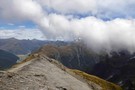
Looking south from Sysiphus Peak
Photograph
•
Distance: 5.3km away
The Matukituki East Branch winds its way down to meet the West Branch, where we started this walk yesterday. It's ...
More ▶︎
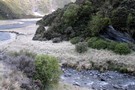
Rainbow Stream
Photograph
•
Distance: 5.3km away
Probably at about 1000m here, 500m above Aspiring Flats visible below.
We faffed around somewhere near here and lost a couple ...
More ▶︎
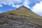
Sisyphus Peak from Wilmot Saddle
Photograph
•
Distance: 5.3km away
Still 200m to go.
Sisyphus Peak (1859m) from Wilmot Saddle (1682m).
More ▶︎
Aspiring Flat and Sisyphus Peak
Track
•
3 days. Medium. Return via same track.
•
Distance: 5.3km away
A one and two-half day tramp up the East Matukituki to overnight in Aspiring Flats, with a day trip up ...
More ▶︎
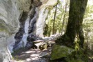
Rock of Ages Bivouac
Rock bivouac
•
Distance: 6.9km away
An overhang above the Kitchener River and Aspiring Flats, near the Matukituki East Branch. Room to sleep 10, although exposed ...
More ▶︎
Rock of Ages bivvy - Mt.Aspiring Flats
Photograph
•
Distance: 7.2km away
A short distance from the East Matukituki, through which flows Kitchener stream is Aspiring Flats. Coveniently located is a rock ...
More ▶︎
North Ruth Flat Rock Bivvy
Rock bivouac
•
Distance: 7.7km away
Good rock bivvy formed by an overhanging rock cliff located north of Ruth Flat in the East Matukituki. On topo ...
More ▶︎
Frosty Morning in the East Matukituki
Photograph
•
Distance: 7.9km away
Taken from near the rock biv at the top of Ruth Flats looking North towards Rabbit Pass in the clouds.
More ▶︎
Rabbit Pass - Wilkin to East Matukituki
Track
•
1 day. Hard. One way.
•
Distance: 7.9km away
A fair weather route linking the upper Wilkin valley to the head of the East Matukituki. Two dangerous climbs are ...
More ▶︎
Ruth Flat Bivy
Photograph
•
Distance: 7.9km away
Found at the North End of Ruth Flat this bivy provides easy accomodation for those not wanting to carry on ...
More ▶︎
Rabbit Pass is up there
Photograph
•
Distance: 9.5km away
View from the East Branch Matukituki River of the descent from Rabbit Pass
More ▶︎