Nearby
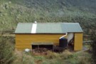
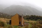
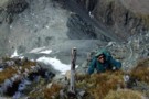
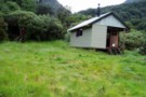
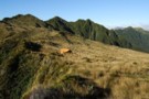
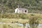
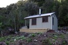
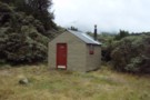
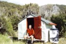
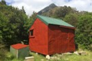
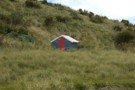
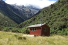
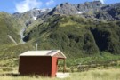
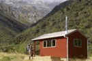
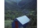
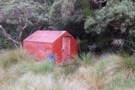
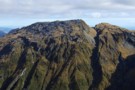
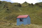
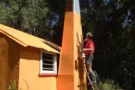
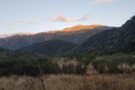
Campbell biv
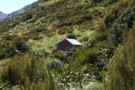
Campbell biv Feb 2009
Photograph
•
Distance: less than 100m away
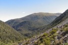
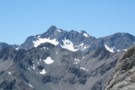
A 1950's vintage cullers biv located on a west facing spur of the Campbell Range. From the biv there are ...
More ▶︎
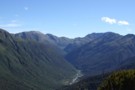
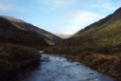
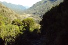
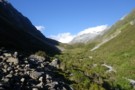
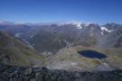
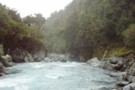
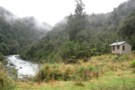
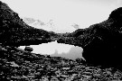
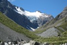
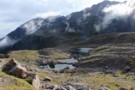
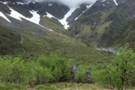
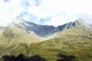
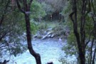
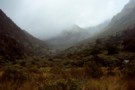
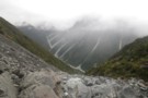
Looking down the Arahura River from near Campbell biv Feb 2009
Photograph
•
Distance: less than 100m away
This pic shows the Arahura River as far as the "big bend" where it goes out of sight then it ...
More ▶︎
Picton to Aspiring
GPX file
•
Distance: 2.9km away
An aborted alpine traverse. Picton to West Cape, but aborted at Aspiring due to real world emergencies back home. Posted ...
More ▶︎

Route Guide: Otira to Mt Cook Village (pt 1)
Track
•
12 – 21 days. Hard. One way.
•
Distance: 2.9km away
One possible route down the main divide from Otira on the Arthur's Pass road to Mt Cook Village.
Otira Hotel to ...
More ▶︎

Route Guide: Otira to Mt Cook Village (pt 2)
Track
•
12 – 21 days. Hard. One way.
•
Distance: 2.9km away
One possible route down the main divide from Otira on the Arthur's Pass road to Mt Cook Village.
Otira Hotel ...
More ▶︎
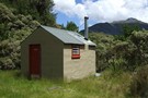
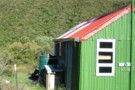
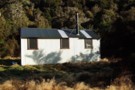
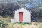
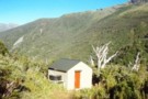
Mudflats Hut
Photograph
•
Distance: 2.9km away
Mudflats Hut, in the Arahura Valley, Westland.
More ▶︎
Mudflats Hut
Hut
•
Standard Hut (DOC). Capacity: 6.
•
Distance: 2.9km away
Mudflats Hut (6 bunks, matresses, tank water, stove, firewood available) lies in the mid-reaches of the Arahura Valley in Westland. ...
More ▶︎
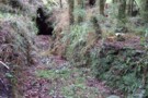
Arahura Valley
Photograph
•
Distance: 2.9km away
The Arahura Valley from the Mudflats swingbridge.
More ▶︎
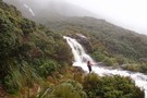
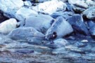
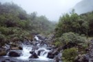
West Coast Streams
Photograph
•
Distance: 3.0km away
En-route from Harman Hut to Grassy Flat Hut. Be mindful that during heavy rain in the New Zealand bush, small ...
More ▶︎
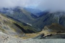
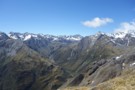
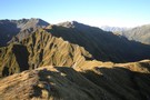
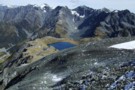
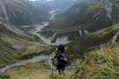
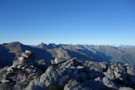
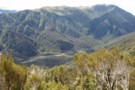
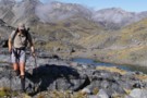
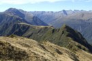
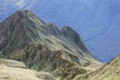
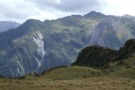
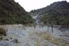
View from un-named Campbell Range saddle
Photograph
•
Distance: 3.0km away
This April 2013 photo was taken from the un-named Campbell Range Saddle at 1600m that is on the direct route ...
More ▶︎
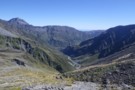
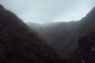
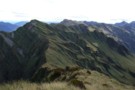
Styx Saddle
Photograph
•
Distance: 3.2km away
Styx Saddle - between the Styx and Arahura valleys in Westland. The Campbell Range forms a backdrop beyond the upper ...
More ▶︎
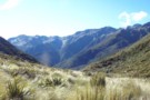
Upper Styx valley
Photograph
•
Distance: 3.5km away
Upper Styx valley and Grassy Flats, from the track over Styx Saddle.
More ▶︎
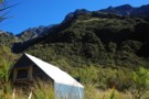
Harman Hut
Photograph
•
Distance: 3.6km away
Harman Hut on a typical West Coast summer day. Pretty basic hut that comes with its own family of weka!
More ▶︎
Harman hut August 1975
Photograph
•
Distance: 3.6km away
This pic was taken after having come down from Browning Pass. Shortly after I snapped the pic it started snowing ...
More ▶︎
Harman Hut
Hut
•
Standard Hut (DOC). Capacity: 6.
•
Distance: 3.6km away
Standard DOC hut at the confluence of the Harman & Arahura rivers. This hut is on the popular "3 passes" ...
More ▶︎
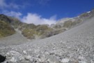
Upper Taipo towards Pope Pass
Photograph
•
Distance: 3.8km away
Upper Taipo towards Pope Pass - boulderfields through the last of the scrub-layer
More ▶︎
Upper Taipo Forks - Pope's Pass & Mt Harman
Photograph
•
Distance: 4.0km away
Upper Taipo Forks - Pope's Pass to right with Mt Harman snowfield (route to Browning Pass) just visible below the ...
More ▶︎
Browning Pass etc from Mt Browning Nov 2017
Photograph
•
Distance: 4.0km away
Looking toward Browning Pass etc from high on Mt Browning.
I climbed up from the Styx Saddle and enjoyed great ...
More ▶︎
Arahura Valley from Mt Harman
Photograph
•
Distance: 4.7km away
Arahura Valley from Mt Harman
More ▶︎
Pope-Browning Pass - looking down the Wilberforce
Photograph
•
Distance: 4.7km away
Pope-Browning Pass on the snowfields on the SE face of Mt Harman. Looking over Lake Browning and down the Wilberforce
More ▶︎
Popes Pass
Photograph
•
Distance: 4.7km away
This picture shows "Alpine" climbing up the start of the ridge leading to Mt Harman with Popes Pass below.
We went ...
More ▶︎
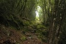
Arahura-Styx track
Photograph
•
Distance: 4.7km away
The Arahura - Styx track: a benched historic pack-horse track through the Arahura and Styx valleys in Westland. An easy ...
More ▶︎
Toaroha/Zit Saddle/Kokatahi/Lathrop Saddle/Styx River Route
Track
•
3 – 5 days. Medium/hard. Loop track with a road section.
•
Distance: 5.3km away
Loop track across 2 Westland saddles, taking in some remote huts
More ▶︎
Newton Creek Hut from Arahura Pack track
Track
•
1 day. Hard. One way.
•
Distance: 5.3km away
Former forest service track that was left to overgrow and suffered further damage from snow loading in winter of 2008.
Fortunately ...
More ▶︎
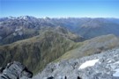
Tops SW of Lake Browning April 2013
Photograph
•
Distance: 5.4km away
I'm sharing this photo of the area near Browning Pass. I guess it must be one of my favoured areas ...
More ▶︎
Julia Hut
Photograph
•
Distance: 5.6km away
Standard DOC hut at the confluence of the Julia & Taipo rivers.
More ▶︎
Julia Hut
Hut
•
Standard Hut (DOC). Capacity: 6.
•
Distance: 5.6km away
Standard DOC hut at the confluence of Julia and Mary Creeks where they meet the Taipo River. Good hot pools ...
More ▶︎
Arahura River & swingbridge
Photograph
•
Distance: 5.6km away
The swingbridge over the Arahura on the track to Newton Creek Hut.
More ▶︎
Mt Brown hut & Newton Range April 2013
Photograph
•
Distance: 5.6km away
This photo shows how the popular Mt Brown hut sits in relation to the Newton Range.
As well as tramps to ...
More ▶︎
Grassy Flat Hut
Hut
•
Standard Hut (DOC). Capacity: 12.
•
Distance: 5.6km away
Grassy Flat Hut (sleeps 12 on 2 platforms, matresses, water, stove) is a modern tramping hut with a large covered ...
More ▶︎
Grassy Flats Hut
Photograph
•
Distance: 5.7km away
Grassy Flats Hut in the upper Styx Valley, Westland. The hut lies on the easy, benched Arahura-Styx track, and is ...
More ▶︎
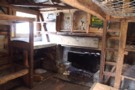
inside old julia
Photograph
•
Distance: 5.7km away
a classic view of the interior of a classic hut. Note the hand hewn locally sourced timbers.
More ▶︎
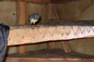
SI Bush Robin in Old Julia hut April 2013
Photograph
•
Distance: 5.7km away
For the second time in about a month a bush robin has spent time in a hut that I've been ...
More ▶︎
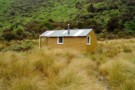
"Old" Julia hut
Hut
•
Basic Hut/Bivvy (DOC). Capacity: 4.
•
Distance: 5.7km away
Close to the "New" Julia hut near the confluence of Julia & Mary Creeks where they join to form the ...
More ▶︎
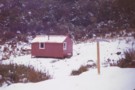
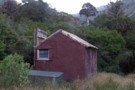
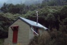
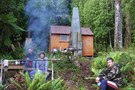
"Old" Julia hut Feb 2009
Photograph
•
Distance: 5.7km away
Close to the "New" Julia hut near the confluence of Julia & Mary Creeks where they join to form the ...
More ▶︎
Harman Pass - Taipo River - Kelly Saddle
Track
•
3 – 5 days. Medium/hard. One way.
•
Distance: 5.7km away
A long journey through the west of Arthur's Pass National Park.
More ▶︎
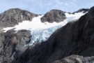
Cronin Icefall
Photograph
•
Distance: 5.7km away
Seen from Whitehorn Pass, the spectacular icefall coming off the Cronin Glacier. Whitehorn Pass is the highest point on the ...
More ▶︎
Three Passes
Track
•
4 – 5 days. Medium/hard. One way.
•
Distance: 5.8km away
A classic trip from Arthur's Pass across Browning, Whitehorn and Harman Passes, emerging near Lake Kaniere on the West Coast.
More ▶︎
Climbing Browning Pass
Photograph
•
Distance: 5.8km away
Ascending the zig-zag tracked part of Browning Pass. It's a steep scramble up the scree at the top, probably better ...
More ▶︎
Lake Browning
Photograph
•
Distance: 5.8km away
Lake Browning, behind Browning Pass. Officially the West Coast after crossing Browning Pass, now the rain starts.
More ▶︎
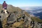
Looking SW from Mt Lathrop March 2017
Photograph
•
Distance: 5.9km away
This is the view looking out over the Crawford and Kokatahi Rivers in a south westerly direction. The Bracken snowfield ...
More ▶︎
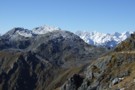
View of Mt Lathrop etc. and further east
Photograph
•
Distance: 5.9km away
This photo looks east along the Browning Range. Lathrop Saddle crosses this scene in front of the prominent Mt Lathrop ...
More ▶︎
Browning Pass zig-zag
Photograph
•
Distance: 6.3km away
The zig-zag trail going up to Browning Pass on the 3 passes route. taken February 2007
More ▶︎
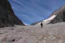
Ascending Whitehorn Snowfield
Photograph
•
Distance: 6.5km away
Only old icy snow on the field in summer. Ice axe recommended for this part, but if confident on ice ...
More ▶︎
Lower Arahura Hut
Photograph
•
Distance: 6.5km away
A nice new 6 bunk hut in the Arahura valley.
More ▶︎
"New" Lower Arahura hut June 2010
Photograph
•
Distance: 6.6km away
A replacement DOC 6 bunk hut for the old NZFS 4 bunk hut that used to sit 30m to the ...
More ▶︎
"Old" Lower Arahura hut (removed)
Photograph
•
Distance: 6.6km away
This photo shows the "old" Lower Arahura hut as it was in January 1976 when it had recently received a ...
More ▶︎
Lower Arahura hut
Hut
•
Standard Hut (DOC). Capacity: 6.
•
Distance: 6.6km away
A new DOC 6 bunk hut that replaces the old 4 bunk NZFS hut. The new hut is 30m east ...
More ▶︎
Jade Prospectors hut at Olderog/Jade Ck confluence Feb 2009
Photograph
•
Distance: 6.6km away
This hut is known by the names of both the creeks it is at the confluence of. We used to ...
More ▶︎
snow ghost
Photograph
•
Distance: 6.6km away
snow ghost, taken from Whitehorn pass Feb 2007.
More ▶︎
Lathrop Saddle
Photograph
•
Distance: 6.6km away
Lathrop Saddle - a hanging valley cutting through the Browning Range between the Styx and Crawford valleys. A marked track ...
More ▶︎
Newton Creek hut Dec 2011
Photograph
•
Distance: 6.7km away
This view of the hut looks SW. The hill in the background is Mt Newton which is on the opposite ...
More ▶︎
Newton Creek Hut
Hut
•
Basic Hut/Bivvy (DOC). Capacity: 4.
•
Distance: 6.7km away
Newton Creek Hut (4 bunk, mattresses, stove, firewood, water) is a pleasant forestry hut beside Newton creek. It's drier and ...
More ▶︎
Cronin Glacier
Photograph
•
Distance: 6.7km away
Cronin valley and glacier on the 3 passes route. taken in perfect weather, February 2007.
More ▶︎
Newton Creek Hut from Arahura Pack track
Article
•
Distance: 6.7km away
Formerly overgrown forest service track that could have led to underuse of lovely hut in magical setting.
More ▶︎
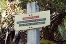
Browning Range Bivouac
Hut
•
Basic Hut/Bivvy (DOC). Capacity: 2.
•
Distance: 6.7km away
'If you're just about buggered, you're just about at Browning Biv'. The sign below the biv says it all: it's ...
More ▶︎
Grassy Flats
Photograph
•
Distance: 6.7km away
Grassy Flats, in the upper Styx Valley (Westland). Taken fron Browning Range Biv, 600m above.
More ▶︎
Browning Range Bivouac
Photograph
•
Distance: 6.7km away
Browning Range Bivouac, on the bush-line in the Browning Range - the hut overlooks the Styx Valley and Grassy Flat, ...
More ▶︎
Browning Range Biv - almost ...
Photograph
•
Distance: 6.7km away
Browning Range Biv - almost there ...
More ▶︎
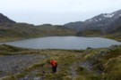
Harman Pass
Photograph
•
Distance: 6.8km away
Looking back over Ariels Tarns to Harman Pass.
More ▶︎
Old Julia Hut
Photograph
•
Distance: 6.9km away
Old Julia Hut after refurbishment in February 2014.
More ▶︎
Crossing Lathrop Saddle
Photograph
•
Distance: 6.9km away
Crossing Lathrop Saddle from the Crawford towards Browning Biv
More ▶︎
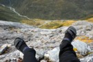
Lathrop Saddle feet dangle
Photograph
•
Distance: 7.1km away
Sitting on the edge of Lathrop. Spot the biv. Descent far right on the tussock spur. Dangling feet highly recommended.
More ▶︎
Newton Range biv
Hut
•
Basic Hut/Bivvy (DOC). Capacity: 2.
•
Distance: 7.2km away
This NZFS biv built in 1962 is perched near the crest of the Newton Range. This range seperates the Arahura ...
More ▶︎
Looking eastward along the Newton Range April 2012
Photograph
•
Distance: 7.2km away
This picture was taken from a spot on the range a bit over an hour west of the bivvy. The ...
More ▶︎
Taipo River track to Julia Hut
Photograph
•
Distance: 7.2km away
Taipo River track to Julia Hut - above Dry Creek
More ▶︎
Newton Range biv Jan 2008
Photograph
•
Distance: 7.3km away
This biv is perched near the crest of the Newton Range. This range seperates the Arahura River to the north ...
More ▶︎
Browning Range
Photograph
•
Distance: 7.4km away
From the Browning Bivvy on the bushline above the Styx River we climbed in the dark to reach the top ...
More ▶︎
"New" Top Crawford hut Feb 2012
Photograph
•
Distance: 7.5km away
This photo is of the "new" Top Crawford hut which is an hour walk up the valley from the location ...
More ▶︎
Rear view of "New" Top Crawford hut
Photograph
•
Distance: 7.5km away
Here is a rear view of the hut. The perspective is looking NNW past the hut and over the two ...
More ▶︎
Top Crawford Hut (New)
Hut
•
Standard Hut (DOC). Capacity: 4.
•
Distance: 7.5km away
This entry is for the "new" Top Crawford hut which is an hour walk up the valley from the location ...
More ▶︎
View East from Top Crawford biv Dec 2010
Photograph
•
Distance: 7.5km away
This pic was taken from the biv & shows the basin immediately East of the biv. Thought the ribbonwoods looked ...
More ▶︎
Mount Learmont
Photograph
•
Distance: 7.5km away
Mount Learmont and the upper Crawford Valley, Westland
More ▶︎
Top Crawford Bivouac
Photograph
•
Distance: 7.5km away
Top Crawford Bivouac, Crawford Valley, Westland
More ▶︎
Top Crawford Bivouac (Removed)
Hut
•
Removed!
•
Distance: 7.5km away
The Top Crawford Bivouac (2 bunks, no matresses, stream water 100m distant, no fire) is a typical alpine Biv, with ...
More ▶︎
Top Crawford Hut
Photograph
•
Distance: 7.5km away
Near old Top Crawford Biv site, this 4 bunk forest service hut was refurbished and relocated in February 2011. It ...
More ▶︎
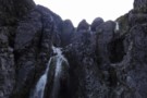
Taipoiti Gorge
Photograph
•
Distance: 7.6km away
Described in DoC literature as "impassable", small waterfalls at the top of the Taipoiti Stream, on the way from Carrington ...
More ▶︎
Crawford Biv looking up Lathrop saddle
Photograph
•
Distance: 7.7km away
Lathrop saddle is off to the right, the spur to it is center above biv.
More ▶︎
Lower Olderog biv (aka Jade biv) Feb 2009
Photograph
•
Distance: 7.9km away
This biv is located on a bench well above the creek bed in the headwaters of Jade Creek. It is ...
More ▶︎
Route down off McArthur Crags to Lower Olderog biv Jan 2010
Photograph
•
Distance: 7.9km away
This pic shows the SE leading spur off the top of Mt McArthur that leads down to Lower Olderog biv. ...
More ▶︎
Lower Olderog biv (aka Jade biv)
Hut
•
Basic Hut/Bivvy (DOC). Capacity: 2.
•
Distance: 7.9km away
This NZFS biv dating from 1957 is located on a bench well above the creek bed in the headwaters of ...
More ▶︎
Blue Ducks
Photograph
•
Distance: 8.0km away
Blue Ducks on Crawford Creek, Westland. Between Top Crawford Hut and Top Crawford Bivouac
More ▶︎
Newton Saddle
Photograph
•
Distance: 8.2km away
Newton Saddle between Dunns Creek (hut) and Newton Creek (hut), Westland
More ▶︎
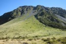
Faultline on Mt Olson May 2013
Photograph
•
Distance: 8.2km away
This picture shows a fault line on the eastern side of Mt Olson (1603m)
Mt Olson is a hill in ...
More ▶︎
Park Morpeth Hut
Hut
•
Standard Hut (DOC). Capacity: 6.
•
Distance: 8.2km away
This is a Canterbury Mountaineering Club Hut, and it appears in DOC's hut list. On the classic Three Passes route.
More ▶︎
View of McArthur Crags from the Newton Range Jan 2008
Photograph
•
Distance: 8.6km away
This picture was taken from just north of the Newton Range biv. I took it to show the band of ...
More ▶︎
Tops route between Lower & Top Olderog bivs Jan 2010
Photograph
•
Distance: 8.7km away
This pic was taken from the summit of the McArthur Crags. The ridge running NE away from the viewers eye ...
More ▶︎
Top Olderog biv
Hut
•
Basic Hut/Bivvy (DOC). Capacity: 2.
•
Distance: 8.7km away
This biv was built by the NZFS in 1971. It is located on the TR in the headwaters of the ...
More ▶︎
Top Olderog biv Jan 2010
Photograph
•
Distance: 8.7km away
This biv is located on the TR in the headwaters of the main branch of Olderog Creek. It is well ...
More ▶︎
Lake Kaniere - Otira
GPX file
•
Distance: 8.7km away
from the north end of Lake Kaniere, along the west shore to the Styx river. East along the Styx to ...
More ▶︎
Mid Taipo Hut to Dunns Creek Hut
Track
•
Medium. Return by the same track.
•
Distance: 8.9km away
The more direct route from Mid Taipo to Dunns Creek, the alternative to heading all the way up Dunns Ck ...
More ▶︎
Mid Taipo hut June 2009
Photograph
•
Distance: 8.9km away
An ex NZFS hut that was built in 1973. In the 70's it was known as "New Mid Taipo" because ...
More ▶︎
Mid Taipo hut
Hut
•
Standard Hut (DOC). Capacity: 6.
•
Distance: 8.9km away
An ex NZFS hut that was built in 1973. In the 70's it was known as "New Mid Taipo" because ...
More ▶︎
Dunns Creek
Photograph
•
Distance: 9.0km away
Dunns Creek, rough scrub on the ascent to Newton Saddle
More ▶︎
Mid Styx Hut painting March 2014
Photograph
•
Distance: 9.0km away
Volunteers have prepared & painted the hut exterior. This is just the second paint job this 1960 built hut has ...
More ▶︎
Track to Mid Styx Hut
Track
•
Easy. Loop track.
•
Distance: 9.1km away
Recently recut 40 minute track to this front country hut renovated by volunteers from the Permolat on-line community.
More ▶︎
Mid Styx hut Feb 2009
Photograph
•
Distance: 9.1km away
This photo of Mid Styx hut was taken during a "Permolat" working bee when a group of volunteers worked on ...
More ▶︎
Mid Styx Hut
Hut
•
Basic Hut/Bivvy (NA). Capacity: 4.
•
Distance: 9.1km away
4 person ex-NZFS hut with open fireplace on north facing terrace high above the Styx River. Renovated extensively and maintained ...
More ▶︎
Mid Styx Hut
Article
•
Distance: 9.1km away
Our trip in to check out this hut restored by the Permolat Community
More ▶︎
Short cut to Mid Styx hut
Photograph
•
Distance: 9.1km away
This photo shows the turnoff to Mid Styx hut as described below.
Easiest access to Mid Styx hut is the Styx ...
More ▶︎
View from Dunns Creek Hut
Photograph
•
Distance: 9.2km away
View from Dunns Creek Hut, early evening in April.
More ▶︎
Dunns Creek Hut
Photograph
•
Distance: 9.2km away
The marshes in the mid-reaches of Dunns Creek. Dunns Creek Hut is visi ble on the right: a wet spot!
More ▶︎
Top Crawford Hut
Photograph
•
Distance: 9.4km away
Top Crawford Hut, Crawford Creek, Westland.
More ▶︎
Top Crawford Hut (Removed)
Hut
•
Removed!
•
Distance: 9.4km away
Top Crawford Hut (4-bunks, matresses, tank water, no fire) is a typical forestry-style hut. It's located on a small terrace ...
More ▶︎

Arthur's Pass National Park
Place
•
National Park. 1145.00km2.
•
Distance: 9.5km away
This alpine park straddles the Main Divide of the Southern Alps, with dry beech forests in the east and damp ...
More ▶︎
Old Water Race below Lower Arahura hut
Photograph
•
Distance: 9.5km away
Here is a photo of a remnant section of the water race that runs roughly parallel with the current track ...
More ▶︎
Dry Creek
Photograph
•
Distance: 9.5km away
Dry Creek - descending into the Taipo from it's 1700m saddle off Hunts Creek
More ▶︎
Kelly Tops, Dry Creek, Taipo Circuit
Article
•
Distance: 9.6km away
A 3 day circuit from 7 Mile Creek to the Kelly Tops, down to Hunts Saddle and then over Hunts ...
More ▶︎
Dunns Creek Hut
Hut
•
Standard Hut (DOC). Capacity: 4.
•
Distance: 9.6km away
Dunns Creek Hut (4 bunks, stove, limited dry firewood, tank & creek water, mattresses). The hut sits at the back ...
More ▶︎
Ascent to Dunns Creek Hut
Photograph
•
Distance: 9.9km away
On reaching the waterfalls in Dunns Creek, this slip on the true left must be climbed for 100m or-so before ...
More ▶︎
View south from Mt Tara Tama
Photograph
•
Distance: 9.9km away
This photo shows a large expanse of Westland back country and some peaks on the Canterbury side of the main ...
More ▶︎
Kellys Range & beyond from Kellys Hill July 2011
Photograph
•
Distance: 9.9km away
This pic looking SW from Kellys Hill was taken before this weeks heavy snowfalls. The dip in the foreground is ...
More ▶︎