Nearby
Gentle Annie Point
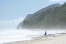
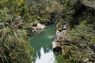
Beach near Gentle Annie Point
Photograph
•
Distance: 1.6km away
A beautiful and secluded West Coast beach.
More ▶︎
Chasm Creek Track
Track
•
Easy. Return via same track.
•
Distance: 4.9km away
A short walk along an old section of railway. A tunnel, a sculpted creek, and views of the Mokihinui River.
More ▶︎
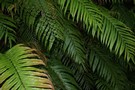
Hound's tongue fern and kanono
Photograph
•
Distance: 4.9km away
Growing in a tangle at the edge of the Chasm Creek Track.
More ▶︎
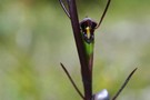
Orthoceras novae-zeelandiae
Photograph
•
Distance: 4.9km away
Orchid growing in clay on the Chasm Creek Track.
More ▶︎
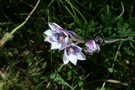
Thelymitra pulchella
Photograph
•
Distance: 4.9km away
Sun orchid growing in clay, Chasm Creek Track.
More ▶︎
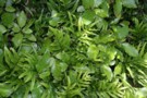
Kiokio
Photograph
•
Distance: 4.9km away
Kiokio (Blechnum) growing alongside the Chasm Creek Track.
More ▶︎
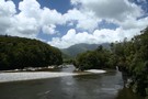
Warrigal Island, Mokihinui River
Photograph
•
Distance: 4.9km away
A tiny island in the lower reaches of the river between Mokihinui and Seddonville.
More ▶︎
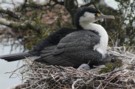
nesting shags
Photograph
•
Distance: 6.1km away
Pied Shag nesting near the Chasm Creek Walkway on the Mokihinui River, north of Westport
More ▶︎
Old Ghost Road
GPX file
•
Distance: 7.9km away
A GPS track of the Old Ghost Road November 2017
More ▶︎
Charming Creek Walkway
Track
•
Easy. One way.
•
Distance: 8.8km away
One of Buller's longer established walkways that is also open to mountain bikers.
The majority of the 10.5 km route ...
More ▶︎
Mt Glasgow 1424m
Track
•
1 – 2 days. Medium. Return via same track.
•
Distance: 9.4km away
A superb day walk in behind the sleepy village of Seddonville.
More ▶︎
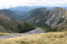
View in easterly direction from summit of Mt Glasgow
Photograph
•
Distance: 9.4km away
View in easterly direction from summit of Mt Glasgow. Taken 04/02/2012
More ▶︎
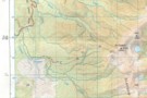
Mt Glasgow track map
Photograph
•
Distance: 9.4km away
Approximate position of track plotted on copy of NZ Topo 50 map. Crosses indicate position plotted from a GPS reading
More ▶︎