Nearby
Matukituki to Paradise by roads less travelled
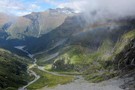
Route from Pine Creek to Matukituki Valley via Shotover Saddle
GPX file
•
Distance: less than 100m away
(Partial) route from Pine Creek to Matukituki via Shotover Saddle. The cattle track passage in this file is probably very ...
More ▶︎
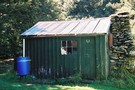
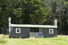
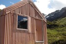
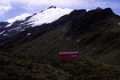
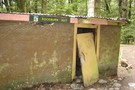
Tummel Burn Hut
Hut
•
Basic Hut/Bivvy (PVT). Capacity: 3.
•
Distance: less than 100m away
Low 3 person unbunked private hut with open fire. 3 mattresses present (2009). Water supply from Tummel Burn 20m distant. ...
More ▶︎
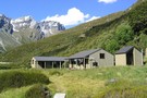
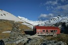
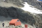
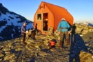
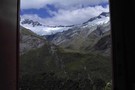
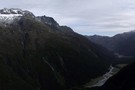
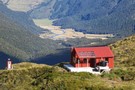
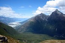
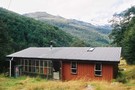
Shelter Rock Hut
Hut
•
Serviced Hut (DOC). Capacity: 22.
•
Distance: less than 100m away
In the Rees Valley. One of the huts on the Rees-Dart Track
More ▶︎
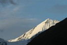
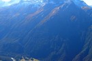
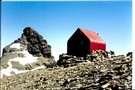
Shelter Rock Hut
Photograph
•
Distance: less than 100m away
Shelter Rock Hut in its surrounding mountains
More ▶︎

Haast to The Divide
GPX file
•
Distance: less than 100m away
Andrew Barker's traverse 2009. From Pleasant Flat in the Haast to The Divide via Mt Aspiring National Park.
More ▶︎
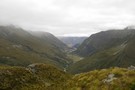
Lochnagar/Shotover Saddle/Matukituki Valley
Track
•
2 days. Medium/hard. One way.
•
Distance: less than 100m away
An alpine crossing of a saddle between 2 major river valleys. Usually done as part of a circuit of saddle ...
More ▶︎
Rees-Dart Track
Track
•
3 – 4 days. Medium/hard. Loop track.
•
Distance: less than 100m away
Alpine circuit along two river valleys at the head of Lake Wakatipu.
More ▶︎
Aspiring - Rees
GPX file
•
Distance: less than 100m away
Starting at Raspberry Flat, this track passes Mt Aspiring Hut in the West Matukituki Valley and then climbs steeply to ...
More ▶︎
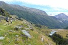
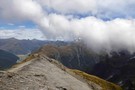
route from Snowy Creek to Lochnagar via Shotover Saddle
Photograph
•
Distance: less than 100m away
Hand drawn route of above
More ▶︎
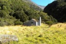
Lochnagar Hut
Hut
•
Private hut (PVT). Capacity: 4.Bookings required.
•
Distance: less than 100m away
Old style musterers hut yet rebuilt in 1990. Painted corrugated iron half buried in earth with a partial schist slabbed ...
More ▶︎
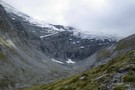
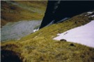
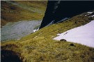
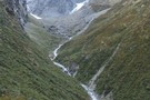
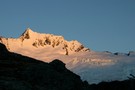
Snowy Creek
Photograph
•
Distance: less than 100m away
Snowy Creek - viewed from saddle 1950 on the way over from Lochnagar Hut
More ▶︎
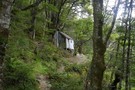
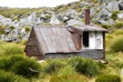
Earnslaw Hut
Photograph
•
Distance: less than 100m away
Rough four-bunk historic hut below Kea Basin on the ascent to Mt Earnslaw
More ▶︎
Earnslaw Hut
Hut
•
Basic Hut/Bivvy (DOC). Capacity: 4.
•
Distance: less than 100m away
Earnslaw hut. Located near Kea Basin on the slopes of Mt Earnslaw, above the Rees valley.
More ▶︎
French Ridge
Track
•
2 – 4 days. Medium. Return via same track.
•
Distance: less than 100m away
A steep climb to the snowline in the West Matukituki.
More ▶︎
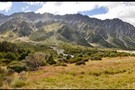
rees valley
Track
•
3 days. Medium. Return via same track.
•
Distance: less than 100m away
pleasant walk up the rees valley. the track gets a bit swampy at the start and then a few avalance ...
More ▶︎
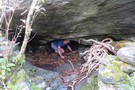
Kea Basin Bivvy - Mt.Earnslaw
Photograph
•
Distance: less than 100m away
This is one of the best bivvy rocks i've seen. Situated at appx 1060m on the north flank of Mt.Earnslaw. ...
More ▶︎
Snowy Creek
Photograph
•
Distance: less than 100m away
Looking down Snowy Creek to Rees Saddle
More ▶︎
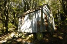
Earnslaw Hut - Mt.Earnslaw - Mt.Aspiring NP
Photograph
•
Distance: less than 100m away
At appx 980m set in beech forest above the Rees valley. This historic hut is on a short 50m side ...
More ▶︎
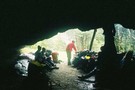
Looking inside Earnslaw Hut - Mt.Aspiring NP
Photograph
•
Distance: less than 100m away
An old hut with a distinctive rustic look. I believe many people would prefer to occupy the rock bivvy at ...
More ▶︎
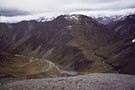
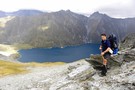
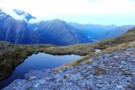
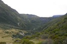
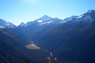
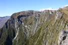
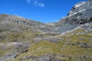
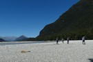
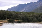
Rees Saddle
Photograph
•
Distance: 126m away
This picture was take at the top of the rees saddle looking down towards the rees vally in december 2006
More ▶︎
Rees Saddle from near Cleft Peak
Photograph
•
Distance: 126m away
Rees Saddle from near Cleft Peak; Snowy Creek to the right, & the Rees to the left.
More ▶︎
Lochnagar Hut
Photograph
•
Distance: 149m away
A hut was built here at Lochnagar in 1982. It was burnt down in 1988. As part of the 150th ...
More ▶︎
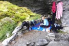
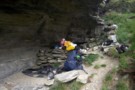
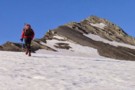
Have we met?
Photograph
•
Distance: 154m away
This may well be the same group that visit us on Shotover Saddle the night after next. The ones who ...
More ▶︎
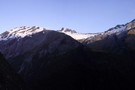
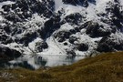
Standing above Lochnagar (Goat Lake) - Mt.Aspiring NP
Photograph
•
Distance: 207m away
No snow in March 2010 on the south facing slopes to the north of Lochnagar. Taken from the col between ...
More ▶︎
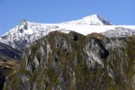
Mt Earnslaw from Earnslaw Burn
Photograph
•
Distance: 208m away
The cirque at the head of the Earnslaw Burn, taken from the descent from Lennox Pass
More ▶︎
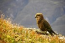
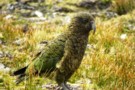
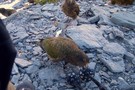
The mind of a mischief at work
Photograph
•
Distance: 220m away
Kea show their usual boundless curiosity in Pine Ck basin.
More ▶︎
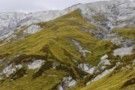
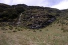
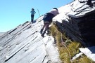
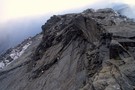
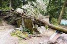
The spur between Snowy Ck and Pine Ck basin - Lochnagar route
Photograph
•
Distance: 223m away
The book at Tummel Burn hut in the upper Shotover would have you believe nine out of ten people descend ...
More ▶︎
Lennox Creek, South Branch
Photograph
•
Distance: 229m away
Upper crossing of Lennox Creek (south branch). Not a place to be with unstable snow above.
The next viable crossing is ...
More ▶︎
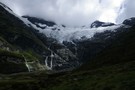
Cascade Saddle Route from Aspiring Hut
Photograph
•
Distance: 245m away
The route does not actually cross the saddle, but follows the rugged spur in the top centre of this photograph, ...
More ▶︎
Mount Aspiring
Photograph
•
Distance: 245m away
Peering over the shoulder of Rob Roy Peak, late afternoon, Aspiring Hut.
More ▶︎
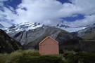
Aspiring Hut
Hut
•
Serviced Alpine Hut (NZAC). Capacity: 38.
•
Distance: 245m away
This historic hut in the West Matukituki Valley was constructed of local schist, and opened at Easter 1949. Situated immediately ...
More ▶︎
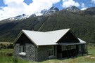
Aspiring Hut
Photograph
•
Distance: 245m away
This 1949 hut is constructed from local schist.
More ▶︎
25 Mile Hut
Hut
•
Removed!
•
Distance: 249m away
*EDIT* From DOCs website:
28 April 2016: Rees Valley - 25 Mile Hut removed
The derelict 25 Mile Hut in the Rees ...
More ▶︎
25-Mile Hut
Photograph
•
Distance: 249m away
This is a derelict Hut on the Rees Dart track. It is in an ideal location on a terrace above ...
More ▶︎
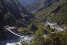
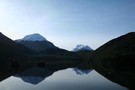
A meeting with the water.
Photograph
•
Distance: 254m away
Providing a different perspective to show the scale of things. Still a couple of hundred metres above the lake. Lochnagar ...
More ▶︎
Dart/Lochnagar
Track
•
1 – 2 days. Hard. One way.
•
Distance: 279m away
10 hour trip from Dart Hut to Lochnagar via Snowy Saddle
More ▶︎
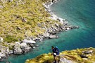
Shotover Saddle
Photograph
•
Distance: 281m away
When we crossed a bridge near to the mouth of the Shotover river just near Queenstown i reminded Kathryn we ...
More ▶︎
Shotover saddle tarn over the West Matukituki
Photograph
•
Distance: 281m away
With the Rob Roy glacier directly across the valley we're looking down valley toward Cameron corner where the East and ...
More ▶︎
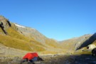
Shotover stopover
Photograph
•
Distance: 281m away
Stopping short of descending to the West Matukituki and camping with sandflies on the valley floor we spent the last ...
More ▶︎
Earnslaw Burn Rock Bivvy, underneath.
Photograph
•
Distance: 314m away
Underneath the Rock Bivvy. This one is about 20 minutes upstream from the official one on the top map and ...
More ▶︎
Earnslaw Burn Rock Bivvy
Rock bivouac
•
Distance: 320m away
This is an alternative bivvy to the one shown on topo maps. This bivvy is about 20 minutes upstream from ...
More ▶︎
Descending to Lochnagar Hut
Photograph
•
Distance: 322m away
Standing above the lake to its north. Showing the outlet which becomes sub-terranian. This spur leads down from Pt.1865 which ...
More ▶︎
Earnslaw Burn Rock Bivvy
Photograph
•
Distance: 323m away
Alternative rock bivvy from the biv shown on the topo map. This bivvy is on the true left of the ...
More ▶︎
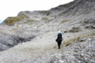
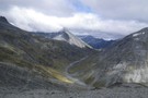
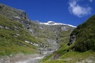
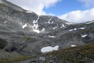
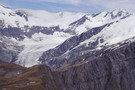
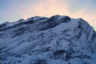
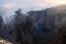
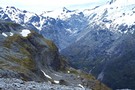
The upper basin of Pine Creek. Mt.Aspiring NP NZ
Photograph
•
Distance: 342m away
After crossing over the pass from Snowy Ck, it was thought we'd get a break from the wind. Fortunately we ...
More ▶︎
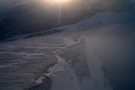
The sun is always brighter on the other side
Photograph
•
Distance: 372m away
That's the last we'll see of the sun tonight. The Rees valley continues to be flooded with rays.
Rees Saddle from ...
More ▶︎
Upper Shotover
Photograph
•
Distance: 381m away
Shotover valley from the spur between Tummel Burn and Tyndall Creek.
More ▶︎
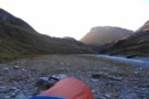
Overnight beside Snowy Ck. - Mt.Aspiring NP NZ
Photograph
•
Distance: 381m away
Looking upstream on Snowy Ck. after crossing Rees saddle. Around the corner is a broad spur giving access to a ...
More ▶︎
Pine Creek
Photograph
•
Distance: 421m away
Upper basin of Pine Creek, crossing to Snowy from Lochnagar
More ▶︎

Snowy Creek
Photograph
•
Distance: 474m away
Snowy Creek - viewed from saddle 1950 on the way over from Lochnagar Hut
More ▶︎

Snowy Creek
Photograph
•
Distance: 474m away
Snowy Creek - viewed from saddle 1950 on the way over from Lochnagar Hut
More ▶︎
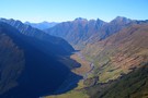
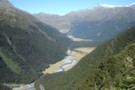
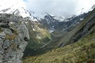
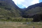
Rees valley
Photograph
•
Distance: 851m away
Looking up the Rees valley from near 25-mile spur (April 2009)
More ▶︎
Crossing Lake Creek out of Lochnagar
Photograph
•
Distance: 950m away
The descent from Lochnagar to the Shotover river goes past a sub-terranian outlet before Lake Creek becomes anything significant.
The cableway ...
More ▶︎
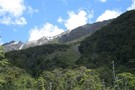
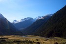
West Matukituki valley
Photograph
•
Distance: 1.5km away
Looking up the West Matukituki valley
More ▶︎
Rees Vally
Photograph
•
Distance: 1.6km away
A photo taken looking towards the rees saddle, taken inbetween rees saddle and shelter rock hut
More ▶︎
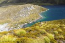
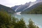
Lochnagar landslide dam
Photograph
•
Distance: 1.7km away
Lochnagar landslide dam, looking up Lake creek
More ▶︎

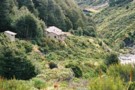
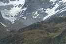
Cascade hut
Photograph
•
Distance: 1.8km away
Cascade hut in the West Matukituki valley, about 10km from the carpart, only about 1.5km short of Aspiring hut.
More ▶︎
Cascade hut
Photograph
•
Distance: 1.8km away
Cascade hut in the West Matukituki valley, about 10km from the carpart, only about 1.5km short of Aspiring hut.
More ▶︎
Cascade hut
Photograph
•
Distance: 1.8km away
Cascade hut in the West Matukituki valley, about 10km from the carpart, only about 1.5km short of Aspiring hut.
More ▶︎
Glengyle Peak
Photograph
•
Distance: 2.1km away
Taken from below the Pylon on the Cascade Saddle route looking across the West matukituki towards Glengyle. If you look ...
More ▶︎
Lower Matukituki
Photograph
•
Distance: 2.1km away
Taken from the Cascade Saddle route a short distance below the Pylon looking downvalley towards the carpark at Raspberry Flat. ...
More ▶︎
West Matukituki valley
Photograph
•
Distance: 2.1km away
Taken from the Cascade Saddle route not far below the Pylon, looking up valley towards Mt Aspiring which towers above ...
More ▶︎
from Cascade Saddle
Photograph
•
Distance: 2.2km away
looking to the SE from Cascade Saddle, across Heads Leap to Cascade Falls
More ▶︎
Approaching Mt Tyndall
Photograph
•
Distance: 2.5km away
Mt Tyndall (2,496m) sits above the Isobel Glacier south of Cascade Saddle.
More ▶︎
Mt Tyndall
Photograph
•
Distance: 2.5km away
from Cascade Saddle, looking south-east across Heads Leap to Mt Tyndall (2496m) (April 2009)
More ▶︎
Shovel Flat in the West Matukituki
Photograph
•
Distance: 2.5km away
A beutiful spot with heaps of great camping sites, French Ridge is the major ridge descending to the valley floor ...
More ▶︎

Cascade Saddle
Photograph
•
Distance: 2.6km away
Looking down at the Saddle from above Heads Leap. A 500 metre cliff drops off to the Cascade creek floor ...
More ▶︎
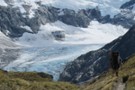
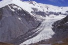
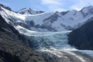
Dart Glacier
Photograph
•
Distance: 2.8km away
Located right beside the Cascade Saddle, a climb to the saddle allows you a view of the intier length of ...
More ▶︎
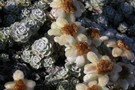
Frozen South Island Edelweiss
Photograph
•
Distance: 2.9km away
Leucogenes grandiceps (thanks john dutchie) on Cascade Saddle, above the Dart Glacier (April 2009)
More ▶︎
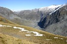
Dart Valley from Cascade Saddle
Photograph
•
Distance: 2.9km away
This is inspiring country (April 2009)
More ▶︎
Cascade Saddle
Track
•
1 – 2 days. Hard. One way.
•
Distance: 3.0km away
Alpine crossing linking the valleys of the West Matukituki and the Dart Rivers.
More ▶︎
My wife crossing the schist slab below the Pylon
Photograph
•
Distance: 3.0km away
Being relatively new to this we found croosing the schist slab below the Pylon fairly tricky. The "track" was a ...
More ▶︎
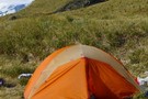
Cascade Saddle Camp
Photograph
•
Distance: 3.0km away
Nice campsite where the Cascade Saddle track crosses the top of Cascade Creek, with Mt Aspiring visible over the ridge. ...
More ▶︎
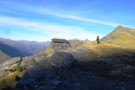
Esquilant Biv
Photograph
•
Distance: 3.1km away
A small 6-bunk hut on the shoulder of Mt Earnslaw. Could comfortably sleep 8, although there is not much room ...
More ▶︎
Esquilant Biv
Photograph
•
Distance: 3.1km away
Gearing up in the early morning to climb Mt Earnslaw. Esquilant is a 6 bunk hut situated at 2,160m.
More ▶︎
Dart Hut
Photograph
•
Distance: 3.3km away
Dart hut, taken from the swing bridge crossing the Snowy stream, just as you approach the hut
More ▶︎
Rees Vally
Photograph
•
Distance: 3.7km away
This is a picture taken on the rees/dart track and is on day 2 of our tramp in between shelter ...
More ▶︎
Esquilant Bivvy Hut
Hut
•
Serviced Alpine Hut (NZAC). Capacity: 6.
•
Distance: 3.8km away
Small hut located on Wright's Col in the Rees Valley.
More ▶︎
Mt Earnslaw
Article
•
Distance: 4.0km away
This was a sweet day trip taken in Feb 2008, bluebird day.
More ▶︎
Pearl Flat to Scott's Bivvy
GPX file
•
Distance: 4.2km away
A new track has been cut through bush up the true left of the Matukituki river from Pearl Flat to ...
More ▶︎
French Ridge Track
Photograph
•
Distance: 4.8km away
The French Ridge Track features tangled roots, steep gradients, and clambering down rock walls.
More ▶︎
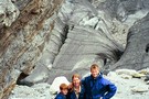
Family on Dart Glacier, 2001
Photograph
•
Distance: 4.9km away
Helen and the boys (then 14 and 11) on Dart Glacier (Rees/Dart tramp).
More ▶︎
Liverpool Hut
Hut
•
Serviced Alpine Hut (DOC). Capacity: 10.
•
Distance: 5.0km away
Located on the steep lower slopes of Mount Barff, this hut offers striking views and a route to the Arawhata ...
More ▶︎
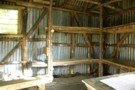
Liverpool Hut toilet
Photograph
•
Distance: 5.0km away
View from the drop toilet at Liverpool Hut
More ▶︎
Liverpool Hut From Behind
Photograph
•
Distance: 5.0km away
view of liverpool hut from behind ..mt apiring to the Left
More ▶︎
Liverpool Hut
Photograph
•
Distance: 5.0km away
-Makeshift Campsite 200 meters from Liverpool Hut
-Hut was full so we could not sleep there but we did cook there
More ▶︎
Rees - Dart
GPX file
•
Distance: 5.0km away
Starting at Muddy Creek, this track heads up the Rees River to the head of the valley with a short ...
More ▶︎
Views from Liverpool hut
Photograph
•
Distance: 5.1km away
The triangle of Mt Aspiring pokes above the skyline to the left, with Mt French and French Ridge in the ...
More ▶︎
West Matukituki from Liverpool hut
Photograph
•
Distance: 5.1km away
Looking down valley from the hut, Rob Roy Peak dominates above Shovel Flat, the Cascade Saddle is visible in the ...
More ▶︎
Liverpool hut
Photograph
•
Distance: 5.1km away
The new (2009) 10 bunk Liverpool hut beneath Mt Barff.
More ▶︎
Liverpool Hut
Photograph
•
Distance: 5.1km away
Liverpool Hut commands and excellent view down the West Matukituki Vallet
More ▶︎
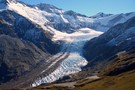
Dart Glacier
Photograph
•
Distance: 5.3km away
on the way to Cascade saddle, the weather just perfect (April 2009)
More ▶︎
Liverpool Hut
Photograph
•
Distance: 5.3km away
Viewed from the French Ridge Track across the valley
More ▶︎
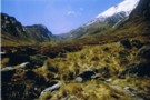
Head of the Matukituki Valley West Branch
Photograph
•
Distance: 5.3km away
Viewed from French Ridge Track.
More ▶︎
Mount Avalanche avalanche
Photograph
•
Distance: 5.5km away
Viewed from the French Ridge Track. Avalanches from here, from Rob Roy Peak, or from peaks across the valley can ...
More ▶︎
Gloomy Gorge
Photograph
•
Distance: 5.5km away
Viewed from the French Ridge Track, with Mount Avalanche in the background.
More ▶︎
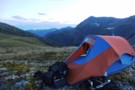
Cattle Flat Biv
Photograph
•
Distance: 5.6km away
Plenty of room for everyone to get out of the rain and enjoy a brew
More ▶︎
Cattle Flat Bivy Rock
Hut
•
Natural shelter (NA).
•
Distance: 5.6km away
A huge shelter rock in the Dart half way between Dart & Daleys Huts. It is back in the bush ...
More ▶︎
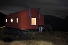
French Ridge Hut at night
Photograph
•
Distance: 5.8km away
210 second exposure @ f / 4.0, 17mm
More ▶︎
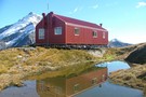
French Ridge Hut Reflection
Photograph
•
Distance: 5.8km away
Reflection of the French Ridge Hut in the tarn on a fine April day.
More ▶︎
French Ridge Hut
Hut
•
Serviced Alpine Hut (NZAC). Capacity: 20.
•
Distance: 5.8km away
This new hut is located on the summer snowline on French Ridge, near the head of the Matukituki Valley West ...
More ▶︎
Aspiring Flat and Sisyphus Peak
Track
•
3 days. Medium. Return via same track.
•
Distance: 6.0km away
A one and two-half day tramp up the East Matukituki to overnight in Aspiring Flats, with a day trip up ...
More ▶︎
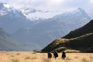
Looking south from Sysiphus Peak
Photograph
•
Distance: 6.0km away
The Matukituki East Branch winds its way down to meet the West Branch, where we started this walk yesterday. It's ...
More ▶︎
French Ridge Hut
Photograph
•
Distance: 6.0km away
This NZAC hut is located on the summer snowline near Mount Aspiring.
More ▶︎
Picton to Aspiring
GPX file
•
Distance: 6.1km away
An aborted alpine traverse. Picton to West Cape, but aborted at Aspiring due to real world emergencies back home. Posted ...
More ▶︎
Mmmmmm tasty
Photograph
•
Distance: 6.5km away
While stopping for a rest on the way back down to the hut a flock of thirteen Keas drop in ...
More ▶︎
Scotts Rock Biv
Rock bivouac
•
Distance: 6.6km away
Located at the head of the Matukituki River West Branch, beyond Pearl Flat.
The biv is 500m upstream of the upper ...
More ▶︎
Rock Formations on French Ridge
Photograph
•
Distance: 6.7km away
Interesting formations on the way up the ridge to the Quarterdeck glacier.
More ▶︎
Mt French
Photograph
•
Distance: 6.8km away
Dawn reveals an overnight dusting of snow covers Mt French and the Quarterdeck glacier.
More ▶︎
Scotts Bivvy
Hut
•
Natural shelter (NA). Capacity: 2.
•
Distance: 7.0km away
A poor shelter for two people. Beware of the resident stream within the bivvy when it rains
More ▶︎
Scotts Bivvy
Photograph
•
Distance: 7.0km away
Standing on top of the Bivvy. The head of the valley beyond
More ▶︎
Gloomy Gorge
Photograph
•
Distance: 7.1km away
An 800 odd metre drop off seperates French Ridge from Gloomy Gorges floor.
More ▶︎
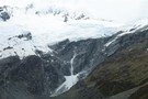
The Quarterdeck Glacier
Photograph
•
Distance: 7.5km away
Taken from the last rock outcrop at the base of the glacier at around about the 1860m mark, Mt French ...
More ▶︎
Rockburn Hut
Photograph
•
Distance: 7.5km away
DOC advises that the Rockburn Hut is closed "due to adverse weather conditions"
.... and a fairly solid tree !
More ▶︎
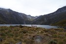
Lake Sylvan
Photograph
•
Distance: 7.6km away
A calm forested lake in the Dart Valley near Glenorchy.
More ▶︎
Lake Sylvan
Track
•
Easy. Loop track.
•
Distance: 7.6km away
A short forest walk to a tranquil lake.
More ▶︎
Rockburn Hut
Hut
•
Basic Hut/Bivvy (DOC). Capacity: 4.
•
Distance: 7.6km away
Rockburn Hut or McIntyres Hut. Near the confluence of Rock Burn and Dart River. A very rough and uninviting hut. ...
More ▶︎

Five Passes via Lake Nerine and North Col
Article
•
Distance: 7.8km away
A classic tramp north of the Routeburn. Rather than exit via the Rockburn, we extended the trip through Lake Nerine ...
More ▶︎
Five Passes
Track
•
6 – 7 days. Medium/hard. Loop track.
•
Distance: 7.8km away
A classic trip starting and finishing at the Routeburn road.
The five passes are; Sugarloaf pass, Park pass, Cow saddle, Fiery ...
More ▶︎
Scott Saddle route (Dart to Caples)
Track
•
1 – 2 days. Medium. One way.
•
Distance: 7.8km away
This route crosses the easiest pass from the Dart to Caples Valleys, via Scott Creek, Scott Saddle and Kay Creek ...
More ▶︎
Dart River
Photograph
•
Distance: 7.9km away
looking down the Dart - about to head into the forest
Feb 2013
More ▶︎
Not The Routeburn
GPX file
•
Distance: 8.0km away
A six-passes, seven catchments trip through the Humboldt Mountains from Glenorchy to The Divide.
Note that for access from Double Barrel ...
More ▶︎
Arawhata Rock Biv
Rock bivouac
•
Distance: 8.2km away
Rock bivouac in the upper Arawhata River.
More ▶︎
beansburn track
Track
•
3 – 5 days. Medium. Return via same track.
•
Distance: 8.5km away
a route that follows the beansburn valley. lake unknown can be reached from here.
times:
beansburn mouth-rock bivvy no 1 1-1.5 ...
More ▶︎
Joe Glacier
Photograph
•
Distance: 9.0km away
A view of the head of the Joe river and the remains of the Joe glacier in Aspiring National Park. ...
More ▶︎
New Dredge Lake
Photograph
•
Distance: 9.4km away
The new lake at Dredge Flat on the Dart River.
More ▶︎
Lake Whakatipu from Sugarloaf
Photograph
•
Distance: 9.8km away
On the five passes route. Lake Whakatipu from just above Sugarloaf pass. taken Jan 2010
More ▶︎
Daley's Flat Hut
Photograph
•
Distance: 9.9km away
Half way up the Dart Valley. This hut is on the Rees Dart track
More ▶︎
Daley's Flat Hut
Hut
•
Serviced Hut (DOC). Capacity: 20.
•
Distance: 9.9km away
This is the oldest hut on the Rees Dart route but is a welcome stop over on the long trip ...
More ▶︎
Daley's Flat Hut
Photograph
•
Distance: 9.9km away
Looking south west down the Dart River. Heavy rain overnight saw the Dart river rise to the top of it's ...
More ▶︎