Nearby
Old Ghost Road
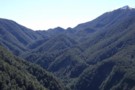
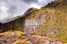
Head of Lyell Creek
Photograph
•
Distance: less than 100m away
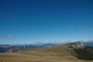
This pic looks up Lyell Creek to Lyell Saddle where the new Lyell Saddle hut has been built. The snow ...
More ▶︎
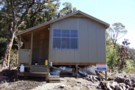
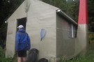
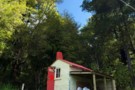
Porch end view of Lyell Saddle hut Sept 2011
Photograph
•
Distance: less than 100m away
Mokihinui-Lyell Backcountry Trust's new hut on Lyell Saddle built as part of one of the NZ Cycle Trail Projects.
More ▶︎
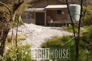
Lyell Saddle hut
Hut
•
Standard Hut (NA). Capacity: 12.Bookings required.
•
Distance: less than 100m away
This recently built hut was started in April 2011. It was initially lived in by track builders but is now ...
More ▶︎
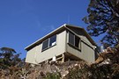
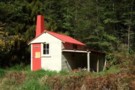
Lyell Saddle hut Sept 2011
Photograph
•
Distance: less than 100m away
This recently built hut was started in April 2011. It was initially lived in by track builders but is now ...
More ▶︎
Stern Valley Hut
Hut
•
Standard Hut (NA). Capacity: 18.Bookings required.
•
Distance: less than 100m away
This recently constructed hut has been built as part of the Old Ghost Road cycleway/tramping route.
There are 2 sleepouts at ...
More ▶︎
Specimen Point Hut
Hut
•
Standard Hut (NA). Capacity: 12.Bookings required.
•
Distance: less than 100m away
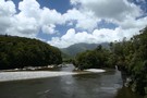
Specimen Point hut is situated on a high point with a commanding view over a stretch of the Mokihinui river.
The ...
More ▶︎
Mokihinui Forks Hut
Hut
•
Basic Hut/Bivvy (DOC). Capacity: 10.
•
Distance: less than 100m away
Mokihinui Forks Hut sits over the south branch of the Mokihinui River, just before it meets the north branch.
The hut ...
More ▶︎
Mokihinui Forks Hut
Photograph
•
Distance: less than 100m away
Mokihinui Forks Hut sits over the south branch of the Mokihinui River, just before it meets the north branch.
More ▶︎
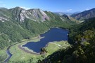
Ghost Lake Hut
Hut
•
Standard Hut (NA). Capacity: 12.Bookings required.
•
Distance: less than 100m away
Ghost Lake hut is perched high on the Lyell Range close above a tarn "Ghost Lake". There are extensive views ...
More ▶︎
Old Ghost Road
Track
•
4 – 5 days. Easy/medium. One way.
•
Distance: less than 100m away
This new trail links the ghost town of Lyell with the Mokihinui River. The first section is open from 2 ...
More ▶︎
Old Ghost Road
Track
•
3 – 5 days. Medium. One way.
•
Distance: less than 100m away
A four or five day tramp from the Lyell Campsite(off SH6 in the Buller Gorge) to the Mokihinui road end ...
More ▶︎

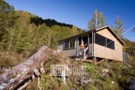
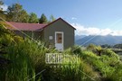
Lyell Saddle Hut
Photograph
•
Distance: less than 100m away
One of four new huts which the Mokihinui-Lyell Backcountry Trust has established on the Old Ghost Road cycle trail.
Lyell Saddle ...
More ▶︎
Ghost Lake Hut
Photograph
•
Distance: less than 100m away
One of four new lodges built by the Mokihinui-Lyell Backcountry Trust on their Old Ghost Road cycle trail. Perched above ...
More ▶︎
Mokihinui Forks Hut - renovated
Photograph
•
Distance: less than 100m away
In 2013 DOC doubled the size of Mok Forks Hut which includes more bunks inside a new foyer. Total of ...
More ▶︎
Goat Creek Hut (DOC)
Photograph
•
Distance: less than 100m away
In 2013 this historic hut built in 1957 was cleaned up. The old graffiti wall is still intact, and the ...
More ▶︎
Stern Valley Hut
Photograph
•
Distance: less than 100m away
One of four new huts which the Mokihinui-Lyell Backcountry Trust has established on the Old Ghost Road cycle trail.
Stern Valley ...
More ▶︎
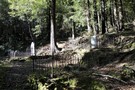
Pioneer Cemetery Walk
Track
•
Easy. Return via same track.
•
Distance: 104m away
A brief, easy walk to Lyell Cemetery, hidden under beech forest above the creek.
More ▶︎
Goat Creek hut Sept 2009
Photograph
•
Distance: 107m away
A charming hut situated on the TR of the South Branch of the Mokihinui River at the confluence with Goat ...
More ▶︎
Goat Creek hut
Hut
•
Basic Hut/Bivvy (DOC). Capacity: 4.
•
Distance: 107m away
A charming hut situated on the TR of the South Branch of the Mokihinui River at the confluence with Goat ...
More ▶︎
Lyell Campsite
Campsite
•
Standard Campsite (DOC). 18 spaces.
•
Distance: 127m away
This grassy camping space occupies a terrace above Lyell Creek, next to Kawatiri / the Buller River. The site was ...
More ▶︎
Specimen Point Hut
Photograph
•
Distance: 162m away
One of four new huts which the Mokihinui-Lyell Backcountry Trust has established on the Old Ghost Road cycle trail.
Specimen Point ...
More ▶︎
Lyell Walkway
Track
•
Easy. Loop track.
•
Distance: 1.6km away
This loop track under pretty beech forest explores the history of the gold mining town of Lyell, including cemetery, stamper ...
More ▶︎
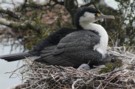
nesting shags
Photograph
•
Distance: 2.0km away
Pied Shag nesting near the Chasm Creek Walkway on the Mokihinui River, north of Westport
More ▶︎
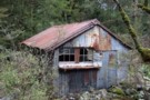
Derelict miners hut Lyell Creek May 2014
Photograph
•
Distance: 2.8km away
This photo shows a surviving historic miners hut near the confluence of Lyell Creek and Irishmans Creek. (It is on ...
More ▶︎
Mt Glasgow 1424m
Track
•
1 – 2 days. Medium. Return via same track.
•
Distance: 3.1km away
A superb day walk in behind the sleepy village of Seddonville.
More ▶︎
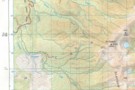
Mt Glasgow track map
Photograph
•
Distance: 3.1km away
Approximate position of track plotted on copy of NZ Topo 50 map. Crosses indicate position plotted from a GPS reading
More ▶︎
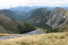
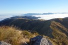
View in easterly direction from summit of Mt Glasgow
Photograph
•
Distance: 3.1km away
View in easterly direction from summit of Mt Glasgow. Taken 04/02/2012
More ▶︎
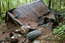
Remains of Eight Mile Hut Lyell Jan 2015
Photograph
•
Distance: 3.1km away
I popped in to this hut when returning from a visit to check out the new Stern Valley and Ghost ...
More ▶︎
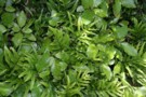
Hound's tongue fern and kanono
Photograph
•
Distance: 3.6km away
Growing in a tangle at the edge of the Chasm Creek Track.
More ▶︎
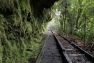
Chasm Creek Track
Track
•
Easy. Return via same track.
•
Distance: 3.6km away
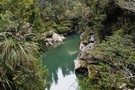
A short walk along an old section of railway. A tunnel, a sculpted creek, and views of the Mokihinui River.
More ▶︎
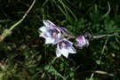
Thelymitra pulchella
Photograph
•
Distance: 3.6km away
Sun orchid growing in clay, Chasm Creek Track.
More ▶︎
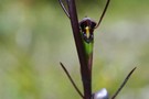
Orthoceras novae-zeelandiae
Photograph
•
Distance: 3.6km away
Orchid growing in clay on the Chasm Creek Track.
More ▶︎
Warrigal Island, Mokihinui River
Photograph
•
Distance: 3.6km away
A tiny island in the lower reaches of the river between Mokihinui and Seddonville.
More ▶︎
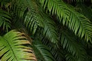
Kiokio
Photograph
•
Distance: 3.6km away
Kiokio (Blechnum) growing alongside the Chasm Creek Track.
More ▶︎
Boscawen Saddle, Rough Creek route
Article
•
Distance: 4.5km away
A description of a weekend tramp up the Nina River, over Boscawen Saddle, sidling to Robinson Saddle, down one branch ...
More ▶︎
Nthn Brunner Range from Mt Curtis
Photograph
•
Distance: 6.0km away
This photo taken from the summit of Mt Curtis (1412m) about 8am in the morning looks generally northward. The hill ...
More ▶︎
Charming Creek Walkway
Track
•
Easy. One way.
•
Distance: 6.1km away
One of Buller's longer established walkways that is also open to mountain bikers.
The majority of the 10.5 km route ...
More ▶︎
Gentle Annie Point
Track
•
Easy. Return via same track.
•
Distance: 7.9km away
A short walk to a secluded West Coast beach.
More ▶︎
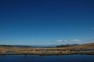
100 Acres Plateau
Photograph
•
Distance: 8.3km away
This is a beautiful tussock landscape dominated by the Needle and the Haystack. Accessed from Larrikin's Creek Hut, there are ...
More ▶︎
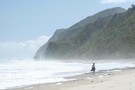
Beach near Gentle Annie Point
Photograph
•
Distance: 8.4km away
A beautiful and secluded West Coast beach.
More ▶︎
Charming Creek Walkway
Photograph
•
Distance: 9.9km away
Charming Creek Walkway north of Westport. I walked it north to south starting at Seddonville. but unless you particularly want ...
More ▶︎
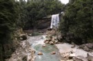
Charming Creek
Photograph
•
Distance: 9.9km away
Waterfall on the Charming Creek Walkway north of Westport. I walked it north to south starting at Seddonville. but unless ...
More ▶︎
Charming Creek
Photograph
•
Distance: 9.9km away
Charming Creek Walkway north of Westport. I walked it north to south starting at Seddonville. but unless you particularly want ...
More ▶︎
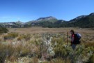
Crossing the plateau.
Photograph
•
Distance: 10.0km away
The long walk across the Thousand Acres Plateau, toward the distant Needle and Haystack.
More ▶︎
1000 Acre Plateau
GPX file
•
Distance: 10.0km away
The route from The Matiri Road end up to the Plateau, Larrikins Hut and on to climb the Needle
More ▶︎