Nearby
Pororari Hut
Paparoa Track
Track
•
3 days. Easy/medium. One way.
•
Distance: less than 100m away
New track located in Paparoa National Park, exploring the Paparoa Range, gold trails and limestone gorges.
Paparoa Track is a dual-use ...
More ▶︎
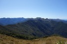
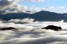
NE from Mt Hawera - Paparoa Range
Photograph
•
Distance: 4.3km away
This photo was taken from a little NE of the the summit of Hawera (1190m) and looks NE toward Mts ...
More ▶︎
Cave Creek / Kotihotiho Track
Track
•
Easy. Return by the same track.
•
Distance: 7.0km away
Scenic walk to the resurgence of Cave Creek.
More ▶︎
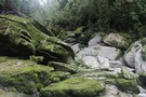
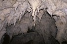
Cave Creek
Photograph
•
Distance: 7.0km away
Cave Creek emerges out of the ground and connects up with the Pororari River.
More ▶︎
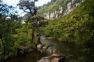
Pororari River Track
Track
•
Easy. Return via same track.
•
Distance: 7.4km away
An easy stroll along the banks of the beautiful Pororari River.
More ▶︎
Cloud across Paparoa from camp on Bovis
Photograph
•
Distance: 7.8km away
Oh Tangaroa, what my eyes tell me is that today is another show off day...(Tuwhare)
More ▶︎
Mt Bovis
Photograph
•
Distance: 7.8km away
Tarn at 1020m elevation, south of peak
Topomap BS20 coord. 751 359
More ▶︎
Former Knobby Ridge Biv
Hut
•
Basic Hut/Bivvy (DOC).
•
Distance: 8.0km away
Originally located on Knobby Ridge, overlooking the Hokitika Gorge, this biv was removed by DOC for a radio base station ...
More ▶︎
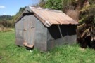
Formerly the Knobby Ridge biv Oct 2011
Photograph
•
Distance: 8.1km away
We saw this biv when emerging from the Inland Pack Track on to the farm track that runs beside the ...
More ▶︎
Mount Bovis
Track
•
1 day. Medium/hard. Return by the same track.
•
Distance: 8.1km away
Day trip to a 1252m summit off the Paparoa Range behind Bullock Creek farm.
More ▶︎
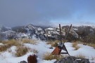
View SE from Mt Bovis August 2011
Photograph
•
Distance: 8.1km away
This pic shows the fallen down trig on the summit of Bovis and looks in a south easterly direction toward ...
More ▶︎
Inland Pack Track
Track
•
2 – 3 days. Easy. One way.
•
Distance: 8.3km away
A beautiful historic route through a coastal karst environment. Gorges, caves, waterfalls, subterranean rivers, sink-holes, swimming, and camping beneath a ...
More ▶︎
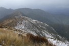
Paparoa Range tops above Moonlight Creek July 2011
Photograph
•
Distance: 8.3km away
This pic was taken off point 1104m on the crest of the Paparoa Range and looks ENE. The foreground ridge ...
More ▶︎
Moonlight Tops Hut
Hut
•
Great Walks Hut (DOC). Capacity: 20.Bookings required.
•
Distance: 8.3km away
Hut servicing the Paparoa Track, located above the treeline on the Paparoa Range.
More ▶︎
Pororari River
Photograph
•
Distance: 9.0km away
This river at Punakaiki is popular with canoes, and has an easy walking track.
More ▶︎
Meikles hut July 2011
Photograph
•
Distance: 9.1km away
This pic is taken from the short branch track off the Moonlight track as you approach the hut from below. ...
More ▶︎
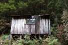
Meikles Hut
Hut
•
Basic Hut/Bivvy (DOC). Capacity: 2.
•
Distance: 9.1km away
Meikles hut is derelict, and a DOC sign warns, "Building unsafe. No Entry."
The first Meikles Hut was an historic ...
More ▶︎
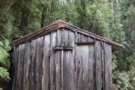
Meikles hut Moonlight track July 2011
Photograph
•
Distance: 9.4km away
This historic hut is derelict. Some people still use it as a place to stop for a boil up using ...
More ▶︎