Nearby
Head to Head Walkway
Foreshore Road Walkway
GPX file
•
Distance: less than 100m away
A flat stroll along an old section of road between Allandale and Governors Bay.
More ▶︎
Crater Rim Walkway: Godley Head to Breeze Col
GPX file
•
Distance: less than 100m away
First section of the Crater Rim Walkway.
More ▶︎
Foreshore Road Walkway
Track
•
Easy. Return by the same track.
•
Distance: 101m away
Follow the closed coastal road between Governors Bay and Allandale in Lyttelton Harbour. Coastal views and easy walking.
More ▶︎
Awaroa/Godley Head Campsite
Campsite
•
Scenic Campsite (DOC). 25 spaces.
•
Distance: 383m away
New campsite located at the mouth of Lyttelton Harbour, next to a WWII defence battery installation.
From the campsite, several ...
More ▶︎
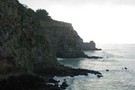
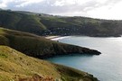
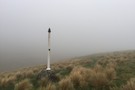
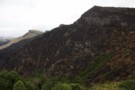
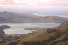
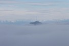
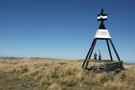
Godley Head
Photograph
•
Distance: 712m away
The WW2 military installations at Godley Head emerge from the fog
More ▶︎
Christchurch 360 Trail: Godley Cliffs section
GPX file
•
Distance: 752m away
Section of the Christchurch 360 Trail, starting at the car park east of Mount Cavendish, Summit Road, Heathcote Valley, Christchurch.
More ▶︎
Faulkners Track
GPX file
•
Distance: 1.2km away
Descend through bluffs to Governors Bay near Christchurch.
More ▶︎
Godley Head Walkway
Track
•
Easy. Loop track.
•
Distance: 1.3km away
A popular coastal walk with sea cliffs and historic military buildings.
More ▶︎
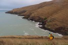
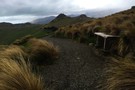
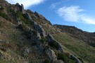
Taylor's Mistake - Godley Head Track
Photograph
•
Distance: 1.3km away
The track is new, wide, easy to follow and scenic
More ▶︎
Cass Ridge Track
GPX file
•
Distance: 1.3km away
Easy descent from the Sign of the Bellbird to the southern end of Ohinetahi Reserve.
More ▶︎
Crater Rim Walkway: Breeze Col to Livingstone Col
GPX file
•
Distance: 1.3km away
Second section of the Crater Rim Walkway.
More ▶︎
Quail Island
Track
•
Easy. Loop track.
•
Distance: 1.5km away
Ever wanted to spend the day in the middle of an old volcano?
More ▶︎
Titoki Track, Ohinetahi Reserve
GPX file
•
Distance: 1.6km away
Very pleasant forest walk, climbing a gully behind Governors Bay.
More ▶︎
Ngaio Track, Ohinetahi Reserve
GPX file
•
Distance: 1.6km away
Grassy walk with views that starts and ends on the Titoki Track.
More ▶︎
Christchurch 360 Trail: Sugarloaf Hills
GPX file
•
Distance: 1.6km away
Section of the Christchurch 360 Trail, starting at Withers car park, Halswell Quarry Park, Kennedys Bush Road, Kennedys Bush.
More ▶︎
Cedrics Track
GPX file
•
Distance: 1.7km away
Short walk near Sugarloaf in the Christchurch Port Hills.
More ▶︎
Mitchells Track
GPX file
•
Distance: 1.7km away
Short walk near Sugarloaf in the Christchurch Port Hills.
More ▶︎
Bowenvale Track
Track
•
Easy/medium. One way.
•
Distance: 1.7km away
Short walk in the Christchurch Port Hills.
More ▶︎
Taylor's Mistake - Godley Head
GPX file
•
Distance: 1.7km away
The track from Taylor's Mistake to Godley head has been redeveloped and reopened after the earthquake.
More ▶︎
Crater Rim Walkway
Track
•
1 day. Easy/medium. One way.
•
Distance: 1.7km away
Follow the ridge of the volcanic Port Hills above Christchurch.
More ▶︎
North Boundary Track
GPX file
•
Distance: 1.7km away
Short side track off Faulkners Track above Governors Bay.
More ▶︎
Crater Rim Walkway: Sign of the Kiwi to Rapaki Rock
GPX file
•
Distance: 1.7km away
Short section past Sugarloaf and Mount Vernon.
More ▶︎
Crater Rim Walkway: Rapaki Rock to Bridle Path
GPX file
•
Distance: 1.7km away
Short section of Christchurch's Crater Rim Walkway.
More ▶︎
Rapaki Track
GPX file
•
Distance: 1.8km away
Wide shared-use track from Rapaki Road in Hillsborough up to the Summit Road on the Christchurch Port Hills.
More ▶︎
Crater Rim Walkway: Sign of the Bellbird to Sign of the Kiwi
GPX file
•
Distance: 1.8km away
Short section between two of the original Summit Road rest houses on the Crater Rim Walkway.
More ▶︎
Gilpins Track
GPX file
•
Distance: 1.8km away
Short walk near Sugarloaf in the Christchurch Port Hills.
More ▶︎
Bush Road Track
GPX file
•
Distance: 1.8km away
Track partly following an old road within Ohinetahi Reserve.
More ▶︎
Ohinetahi Bush Reserve
Place
•
Place. 1.50km2.
•
Distance: 1.8km away
Outstanding block of forest located on eastern slopes of the Christchurch Port Hills above Governors Bay.
More ▶︎
Valley Track, Mount Vernon Park
GPX file
•
Distance: 1.8km away
Paralleling the well-known Rapaki Track, this track leads up the valley floor. The first section to a lunch shelter is ...
More ▶︎
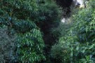
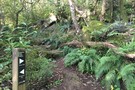
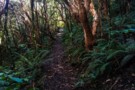
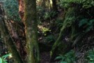
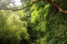
Foliage on the Bivvy Track
Photograph
•
Distance: 1.9km away
A damp, verdant track in the Christchurch Port Hills.
More ▶︎
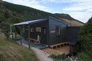
Ōtamahua Hut
Hut
•
Serviced Hut (DOC). Capacity: 12.Bookings required.
•
Distance: 1.9km away
Historic hut on Ōtamahua / Quail Island near Christchurch. This hut is one of the closest huts to Christchurch city, ...
More ▶︎
Trig V
GPX file
•
Distance: 2.0km away
Short track on Christchurch's Port Hills, with views down to Governors Bay and Lyttelton Harbour.
More ▶︎
Trig V Track
Track
•
Easy. One way.
•
Distance: 2.0km away
Short walk in the Christchurch Port Hills.
More ▶︎
Stan Helms Track
GPX file
•
Distance: 2.0km away
Short Port Hills climb near the Bridle Path.
More ▶︎
Duke Street
GPX file
•
Distance: 2.0km away
Very short connector track in Ohinetahi Reserve.
More ▶︎
Crater Rim Walkway: Ahuriri to Sign of the Bellbird
GPX file
•
Distance: 2.0km away
The southernmost section of the Crater Rim Walkway in the Christchurch Port Hills.
More ▶︎
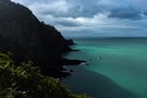
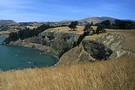
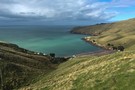
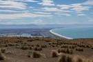
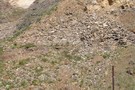
Taylors Mistake
Photograph
•
Distance: 2.1km away
Earthquake-ravaged sea cliffs of Scarborough.
More ▶︎
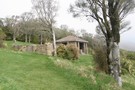
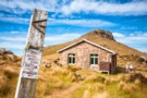
Sign of the Bellbird
Hut
•
Shelter (Christchurch City Council).
•
Distance: 2.1km away
Open stone shelter on Summit Road, Christchurch. The shelter overlooks Kennedys Bush, where there are a number of short walks.
This ...
More ▶︎
Sign of the Bellbird, Christchurch
Photograph
•
Distance: 2.1km away
Sign of the Bellbird, situated in Kennedy's Bush Reserve within the Port Hills of Christchurch.
More ▶︎
Mount Vernon
GPX file
•
Distance: 2.1km away
Short grassy climb from the Summit Road to Mount Vernon (462m). Spectacular 360 degree views from the summit.
More ▶︎
Taylors Mistake Track
GPX file
•
Distance: 2.2km away
Coastal track in the seaside village of Taylors Mistake near Christchurch. Owing to cliff collapse in the February 2011 earthquake, ...
More ▶︎
Taylors Mistake Track
GPX file
•
Distance: 2.2km away
Short coastal walk in a settlement near Christchurch.
More ▶︎
Scarborough Bluffs to Taylors Mistake
GPX file
•
Distance: 2.2km away
Short walk from the valley behind Sumner in Christchurch.
More ▶︎
Huntsbury Track
Track
•
Easy. One way.
•
Distance: 2.2km away
Short walk along a legal road on the Christchurch Port Hills.
More ▶︎
Orongomai Trail
GPX file
•
Distance: 2.2km away
Loop track exploring Kennedys Bush on the Christchurch Port Hills.
More ▶︎
Memorial, Rapaki Track
Photograph
•
Distance: 2.2km away
This pole is a memorial to David Mason, and one of two, marking the sites where two boys died in ...
More ▶︎
Crater Rim Walkway: Bridle Path to Mount Pleasant
GPX file
•
Distance: 2.2km away
Short section of the Crater Rim Walkway from the top of the Bridle Path, past Mount Cavendish and on to ...
More ▶︎
Mount Herbert: Orton Bradley Park approach
Track
•
1 day. Easy/medium. Return by the same track.
•
Distance: 2.2km away
From Charteris Bay, this route leads through Orton Bradley Park to Mount Herbert / Te Ahu Patiki (919m).
More ▶︎
Bridle Path
Track
•
Easy. One way.
•
Distance: 2.2km away
The historic route used by the Canterbury settlers travelling between Lyttelton and Christchurch.
More ▶︎
Bridle Path
GPX file
•
Distance: 2.2km away
Short, sharp historic trail between Christchurch and the port of Lyttelton.
More ▶︎
Totara Trail, Kennedys Bush
GPX file
•
Distance: 2.3km away
Short connector track in the Christchurch Port Hills.
More ▶︎
Mount Ada
GPX file
•
Distance: 2.3km away
Short and easy climb to a Port Hills summit with excellent views over Governors Bay.
More ▶︎
Holdsworth Trail
GPX file
•
Distance: 2.3km away
Short walk in the Christchurch Port Hills. This track connects Kennedys Bush with the Kennedys Bush Track.
More ▶︎
Fantail Trail, Kennedys Bush
GPX file
•
Distance: 2.3km away
Short connector track in the Christchurch Port Hills.
More ▶︎
Quarry Trail, Kennedys Bush
GPX file
•
Distance: 2.4km away
Short track through an old, forested quarry in the Christchurch Port Hills.
More ▶︎
Eastside Bush Track
GPX file
•
Distance: 2.4km away
Sidle between Victoria Park and the Bowenvale Valley.
More ▶︎
Totara Trail, Kennedys Bush
Photograph
•
Distance: 2.4km away
Short, verdant track in Christchurch Port Hills.
More ▶︎
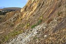
Taylors Mistake
Photograph
•
Distance: 2.4km away
Dropping into the tiny settlement from Scarborough Bluffs.
More ▶︎
Mount Ada after the fires
Photograph
•
Distance: 2.5km away
Mount Ada on the Christchurch Port Hills burned during February's wildfires. Years of revegetation plantings on the summit were destroyed.
More ▶︎
Lamar Track
GPX file
•
Distance: 2.5km away
A short easy-access loop on Mount Vernon in the Christchurch Port Hills.
More ▶︎
Farm Track, Mount Vernon Park
GPX file
•
Distance: 2.5km away
Climb a grassy spur beneath Mount Vernon.
More ▶︎
Bivvy Track
Track
•
Medium. One way.
•
Distance: 2.5km away
Descending from the Christchurch Summit Road into Ohinetahi Reserve.
More ▶︎
Kennedy's Bush Track
GPX file
•
Distance: 2.5km away
A straightforward climb on Christchurch's Port Hills
More ▶︎
Lamar Track
Photograph
•
Distance: 2.6km away
A short, easy-access loop on Christchurch's Port Hills, with extravagant views.
More ▶︎
Major Hornbrook / Crater Rim / Chalmers
GPX file
•
Distance: 2.9km away
From Major Hornbrook head at Somes Road, Lyttelton up to Summit Road then across the Crater Rim, down Chalmers Track ...
More ▶︎
Christchurch 360 TrailL Estuary Marshes
GPX file
•
Distance: 2.9km away
Section of the Christchurch 360 Trail, starting at the Esplanade near Heberden Avenue, Sumner.
More ▶︎
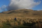
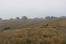
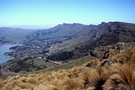
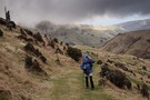
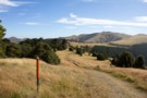
Mt Herbert Walkway
Photograph
•
Distance: 3.1km away
On our way back to Diamond Harbour, looking south along the track to Mt Herbert. Tussock country and farmland, great ...
More ▶︎
Omahu Bush
GPX file
•
Distance: 3.2km away
Omahu Bush is a rich forest reserve on Christchurch's Port Hills. This circuit follows Kirk's and Rhodes Tracks.
More ▶︎
Kirks Track
GPX file
•
Distance: 3.2km away
Marked track descending through Omahu Bush in the Christchurch Port Hills.
More ▶︎
Eastside Bush Track alternate exit
GPX file
•
Distance: 3.2km away
Lower exit onto the Bowenvale Valley.
More ▶︎
Tawhairaunui Trail
GPX file
•
Distance: 3.3km away
Short walk at Victoria Park, designed to be wheelchair accessible, and also suitable for strollers. Several seats and picnic tables ...
More ▶︎
Chalmers Track
GPX file
•
Distance: 3.5km away
Short climb from Lyttelton up onto the Port Hills.
More ▶︎
Marette Taylor Track
GPX file
•
Distance: 3.6km away
Short walk in Mount Vernon Farm Park, Christchurch.
More ▶︎
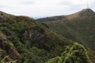
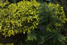
Omahu Bush
Photograph
•
Distance: 3.7km away
This reserve is damp, ferny, and abundant with tree fuchsia.
More ▶︎
Mount Pleasant / Tauhinukorokio
GPX file
•
Distance: 3.8km away
Short walk to the trig on Mount Pleasant / Tauhinukorokio (499m).
More ▶︎
Waterfall Track, Sumner
GPX file
•
Distance: 3.8km away
Short connector track, with no waterfall.
More ▶︎
Captain Thomas Track
GPX file
•
Distance: 3.8km away
Easy climb from Sumner up to the Christchurch Summit Road.
More ▶︎
Valley Track, Mount Vernon Park
Photograph
•
Distance: 3.8km away
The shelter is just 15 minutes from the car park.
More ▶︎
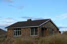
Monument Hut, Banks Peninsula
Hut
•
Basic Hut/Bivvy (NA). Capacity: 8.
•
Distance: 4.1km away
This surprising little hut is a relic of the YHA farm hostel network on Banks Peninsula.
The hut was built ...
More ▶︎
Monument Hut, Banks Peninsula
Photograph
•
Distance: 4.1km away
A small hut near the road on the Purau / Port Levy Saddle.
More ▶︎
Rogers Track
GPX file
•
Distance: 4.1km away
Short track in Mount Vernon Farm Park, connecting the Valley Track with the Rapaki Track.
More ▶︎
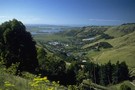
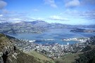
Pegasus Bay
Photograph
•
Distance: 4.2km away
Christchurch and Pegasus Bay from the Crater Rim Walkway, near the Mt Pleasant Bluffs.
More ▶︎
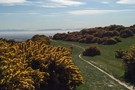
Kennedys Bush Track
Photograph
•
Distance: 4.2km away
If you like gorse, you'll love this track.
More ▶︎
Rogers Track access
GPX file
•
Distance: 4.3km away
Alternate access to Rogers Track in Mount Vernon Park
More ▶︎
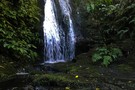
Anne's Falls, Omahu Bush
Photograph
•
Distance: 4.4km away
Perhaps the best waterfall in the best pocket of bush in Christchurch's Port Hills.
More ▶︎
Jollies Bush
Track
•
Easy. Loop track.
•
Distance: 4.5km away
A pleasant loop through a pocket of forest above Sumner.
More ▶︎
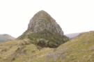
The Monument
Photograph
•
Distance: 4.7km away
A striking volcanic dome behind Purau, popular with climbers.
More ▶︎
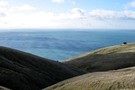
View from the Monument Track
Photograph
•
Distance: 4.8km away
Purau, with the Port Hills and Christchurch beyond. Mount Grey is visible in the haze to the left.
More ▶︎
Eastenders Track
Track
•
Easy. Return by the same track.
•
Distance: 4.8km away
A short Christchurch walk: climb from Barnett Park up to the Summit Road on the Port Hills.
More ▶︎
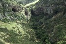
Barnett Park Walkway
Track
•
Easy. Loop track.
•
Distance: 5.3km away
A popular Christchurch walk up a narrow valley to a volcanic cave.
More ▶︎
Gebbies Pass - Sign of the Packhorse
Track
•
0 – 2 days. Easy. Return via same track.
•
Distance: 5.6km away
An easy walk in to the historic Sign of the Packhorse Hut on Banks Peninsula. Closed for lambing August-October.
More ▶︎
Mount Herbert: Gebbies Pass approach
Track
•
1 – 2 days. Easy. Return by the same track.
•
Distance: 5.6km away
A lengthy route along the Crater Rim, past the Remarkable Dykes and the Sign of the Packhorse to Mount Herbert ...
More ▶︎
Te Ara Pātaka
Track
•
2 – 3 days. Easy/medium. One way.
•
Distance: 5.6km away
This track between Gebbies Pass and Hilltop was once surveyed as part of the Banks Peninsula Summit Road, although never ...
More ▶︎
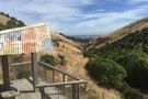
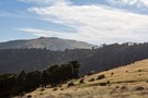
Port Levy Saddle to Mt Herbert
Photograph
•
Distance: 5.8km away
Wind shorn Totara trees beside the ridge track on the way to Mt Herbert - the high point in the ...
More ▶︎
Mount Herbert: Western Valley Road approach
Track
•
Easy. Return by the same track.
•
Distance: 5.8km away
A straightforward route along the unconstructed section of the Summit Road to the highest point on Banks Peninsula: Mount Herbert ...
More ▶︎
Mount Herbert / Te Ahu Patiki
Article
•
Distance: 5.8km away
Approaches on all sides lead to highest point on Banks Peninsula (919m).
More ▶︎
Mount Herbert: Monument Track approach
Track
•
Easy. Return by the same track.
•
Distance: 5.8km away
A farm trail past an historic hut and a lava dome, up to the summit of Mount Herbert / Te ...
More ▶︎
Mount Herbert: Kaituna Valley approach
Track
•
1 day. Easy/medium. Return by the same track.
•
Distance: 5.8km away
A gentle climb to an historic hut, and onward to Mount Herbert / Te Ahu Patiki (919m).
More ▶︎
Mount Herbert Walkway
Track
•
1 day. Easy/medium. Return by the same track.
•
Distance: 5.8km away
A straightforward climb from Diamond Harbour over farmland to the highest point on Banks Peninsula: Mount Herbert / Te Ahu ...
More ▶︎
Mount Herbert Shelter
Hut
•
Shelter (DOC).
•
Distance: 6.0km away
Large open-sided shelter near the summit of Mount Herbert.
More ▶︎
Packhorse Hut Track
Track
•
0 – 2 days. Easy. Return by the same track.
•
Distance: 6.8km away
A gentle climb to the historic "Sign of the Packhorse" hut beneath Mount Bradley on Banks Peninsula. Views of the ...
More ▶︎
Halswell Quarry Rim Track
Track
•
Easy. Loop track.
•
Distance: 6.9km away
A loop track around the Halswell Quarry. Human history, views across the Plains, and striking shapes in the rocks.
More ▶︎
Halswell Quarry Lake Track
Track
•
Easy. Loop track.
•
Distance: 6.9km away
A brief loop along the floor of Halswell Quarry. Dramatic rock formations.
More ▶︎
Sign of the Packhorse
Photograph
•
Distance: 7.0km away
Mount Bradley forms a handsome backdrop to the hut.
More ▶︎
Sign of the Packhorse
Photograph
•
Distance: 7.0km away
Distinctive stone hut located near Mount Bradley.
More ▶︎
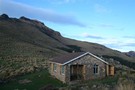
Packhorse Hut
Hut
•
Serviced Hut (DOC). Capacity: 9.Bookings required.
•
Distance: 7.0km away
A stone hut perched on a saddle next to Mount Bradley, with commanding views of Lyttelton Harbour. The "Sign of ...
More ▶︎
Christchurch 360 Trail: Opawaho Divide
GPX file
•
Distance: 7.1km away
Section of the Christchurch 360 Trail, starting at Titoki Street, Riccarton.
More ▶︎
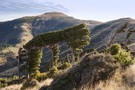
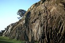
Remarkable Dykes
Photograph
•
Distance: 7.6km away
A pair of rock walls that form the boundaries of a crack in the side of the Lyttelton Volcano. The ...
More ▶︎
Monument Track (south)
GPX file
•
Distance: 7.6km away
Short walk at the head of the Kaituna Valley.
More ▶︎
Monument Track (south)
Track
•
Easy. One way.
•
Distance: 7.6km away
Climb from the head of the Kaituna Valley to Te Ara Pātaka, and the network of tracks running from Purau ...
More ▶︎
Monument Track
Photograph
•
Distance: 7.6km away
Monument Track from the Kaituna Valley side.
More ▶︎
Christchurch
Place
•
Place. 1426.00km2.
•
Distance: 8.7km away
Christchurch is the South Island's largest city, located on the eastern coast near Banks Peninsula.
More ▶︎
Monument Track (south)
Photograph
•
Distance: 8.7km away
Verdant regeneration on this easy Banks Peninsula walk.
More ▶︎
Port Levy Saddle to Rod Donald Hut
GPX file
•
Distance: 8.9km away
Short section of Te Ara Pātaka leading to a new hut. Typical walking time is about 1 hour.
More ▶︎
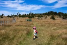
Remnant forest
Photograph
•
Distance: 9.1km away
Pockets of tōtara forest near Port Levy Saddle.
More ▶︎
Christchurch Tramping Club
Club
•
Distance: 9.1km away
The Christchurch Tramping Club (CTC) has members of all ages and runs tramping trips every weekend. Our trips range from ...
More ▶︎
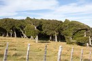
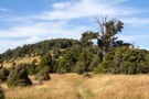
Waipuna Saddle
Photograph
•
Distance: 9.4km away
Wind-shorn tōtara forest and hand-hewn fence posts at Waipuna Saddle.
More ▶︎
Christchurch Banff Mountain Film Festival
Event
•
11 June 2011 00:00 - 23:59.
•
Distance: 9.4km away
Films from the Banff Mountain Film Festival. Hosted by NZ Alpine Club - Auckland section. Two nights 24/May and 1/June.
More ▶︎
Down to Rod Donald Hut
Photograph
•
Distance: 9.5km away
Dropping off Waipuna Saddle to the hut. Mount Herbert in the background.
More ▶︎
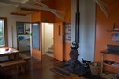
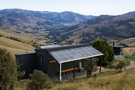
Rod Donald Hut
Hut
•
Serviced Hut (PVT). Capacity: 9.Bookings required.
•
Distance: 9.9km away
Tidy split level hut owned by the Rod Donald Trust and for public use. The hut is located on Te ...
More ▶︎
Rod Donald Hut
Photograph
•
Distance: 9.9km away
New hut that servicing Te Ara Pātaka on Banks Peninsula.
More ▶︎
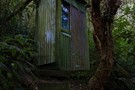
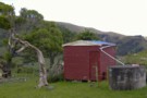
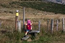
Old toilet, Rod Donald Hut
Photograph
•
Distance: 9.9km away
There is a new toilet, and this is not it. If you like the rustic experience or need a plan ...
More ▶︎
Rod Donald Hut
Photograph
•
Distance: 9.9km away
At night, the view down valley takes in the bright lights of Little River village.
More ▶︎