Nearby
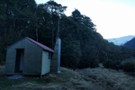
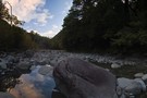
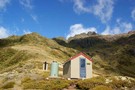
Minchin Bivvy Feb 2016
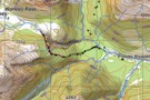
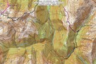
Penny Pass
Track
•
3 – 4 days. Medium. Loop track.
•
Distance: less than 100m away
3 day trip from upper Poulter River over Penny Pass between Minchin and Thompson Streams.
More ▶︎
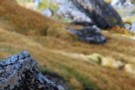
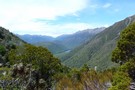
Peak a chamois - Townsend Tops
Photograph
•
Distance: 2.2km away
Occasionally when walking between Townsend hut and Minchin pass you may play peak a boo with the wildlife.
More ▶︎
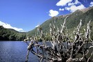
Townsend Hut
Photograph
•
Distance: 3.2km away
Early morning, heading for Lake Minchin to meet the 'Chuzzman' aka 'chuzz'.
More ▶︎
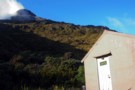
Townsend hut March 2009
Photograph
•
Distance: 3.5km away
Townsend hut which is perched high above the TL of the Taramakau River in the scrub - tussock transition zone ...
More ▶︎
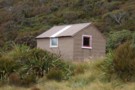
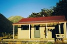
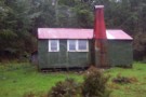
Townsend hut
Hut
•
Basic Hut/Bivvy (DOC). Capacity: 4.
•
Distance: 3.5km away
Townsend hut which is perched high above the TL of the Taramakau River in the scrub - tussock transition zone ...
More ▶︎
Poulter Bivvy
Hut
•
Basic Hut/Bivvy (DOC). Capacity: 2.
•
Distance: 4.0km away
A new 2 bunk D.O.C. bivvy located in the headwaters of the Poulter River. It has two sleeping platforms with ...
More ▶︎
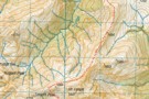
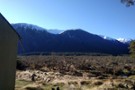
Poulter Hut
Hut
•
Standard Hut (DOC). Capacity: 10.
•
Distance: 6.1km away
Fairly new hut with 8 mattresses on 2 levels of Maori bunks. On flats by the Poulter River at the ...
More ▶︎
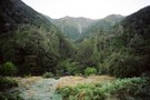
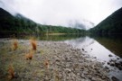
Poulter Hut
Photograph
•
Distance: 6.1km away
At the confluence of Poulter River and Minchin Stream, Arthurs Pass NP
More ▶︎
Harper Pass - Kiwi Saddle
Track
•
5 – 7 days. Medium. One way.
•
Distance: 6.1km away
A classic crossing of the Main Divide, following the deep valleys of the Hope Fault from the Arthur's Pass road ...
More ▶︎
Picton to Aspiring
GPX file
•
Distance: 6.2km away
An aborted alpine traverse. Picton to West Cape, but aborted at Aspiring due to real world emergencies back home. Posted ...
More ▶︎
Locke Stream (No. 4) Hut
Hut
•
Serviced Hut (DOC). Capacity: 18.
•
Distance: 6.3km away
Once known as No. 4 Hut, this hut was build in 1939 as a tourist hut for the Harper Pass ...
More ▶︎
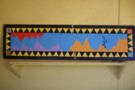
Mural gracing Koropuku hut
Photograph
•
Distance: 6.5km away
I snapped this to show my partner how cultured the inhabitants of back country huts can be. It is topical ...
More ▶︎
Koropuku Hut
Hut
•
Basic Hut/Bivvy (DOC). Capacity: 4.
•
Distance: 6.5km away
Cult Hut! A NZFS 4 bunk beauty with silken wooden floors, no fireplace, tasteful furnishings and domestic accoutrements including the ...
More ▶︎
The Recutting of the NZFS track to Worsley Pass
Article
•
Distance: 6.7km away
How we searched for, found, recut and marked this ancient track that had been lost for 25 years.
More ▶︎
Worsley Biv
Hut
•
Basic Hut/Bivvy (DOC). Capacity: 3.
•
Distance: 6.7km away
Recently renovated (thanks CUTC with Kerry Clapham) with new ridgeline and skylight 'A' frame Maori bunk biv, with 3 foam ...
More ▶︎
NZFS track to Worsley Pass and deer trail route in Poulter Gorge
Photograph
•
Distance: 6.7km away
They were bitchin' in the hut book about this track in 1988. No work done on it for a long ...
More ▶︎
Sidle Mt Valiant
Photograph
•
Distance: 6.9km away
A good direct route from the East Hawdon to the head of the Poulter at Trudge stream, Arthurs Pass National ...
More ▶︎
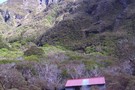
Back down the Poulter from Worsley Pass
Photograph
•
Distance: 7.0km away
Back down the Poulter from Worsley Pass
More ▶︎
Otehake NZFS track up to Big Tops and down to Koropuku Hut
Track
•
1 day. Medium. One way.
•
Distance: 7.2km away
Attractive old track from Otehake swingbridge to open tops. Recent extensions cut from gully to bypass waterfalls.
More ▶︎
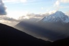
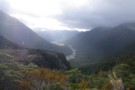
Taramakau in the evening from Big Tops
Photograph
•
Distance: 7.3km away
then the rain came and washed it all away...and yet keeping low doesn't make no sense so little Eiffel stands ...
More ▶︎

Herbfields above Worsley Pass
Photograph
•
Distance: 7.3km away
Herbfields above Worsley Pass
More ▶︎
route from Otehake Track to Big Tops Hut via Koropuku Gorge
Article
•
Distance: 7.5km away
Untracked mission only able to be done when rivers at low flows (usually from December to April).
More ▶︎
'20 minutes' rock, Big Tops
Photograph
•
Distance: 7.8km away
'Lost track of my past/
On deception pass/
Dont know where im going/
Can't recall where ive been'
Deception Pass (Mudhoney)
More ▶︎
Otehake Hot Springs
Photograph
•
Distance: 8.5km away
Otehake hot springs. October 25th 2009.
More ▶︎
route from Otehake Track to Big Tops Hut via Koropuku Gorge
Photograph
•
Distance: 8.5km away
Untracked mission involving 1)crossing of Otehake River. Only able to be done at low flows. @) travel up Koropuku Gorge ...
More ▶︎

Edwards River-Otehake River
Track
•
4 days. Medium. One way.
•
Distance: 8.5km away
Another north-south crossing of the park.
More ▶︎
Otehake Hot Springs
Track
•
2 days. Easy/medium. Return via same track.
•
Distance: 8.6km away
A popular weekend route to good hot pools.
More ▶︎
Grand Traverse of Mt Pfeifer
Article
•
Distance: 8.6km away
Traverse from Kaurapataka Saddle, over summit to Waharoa Saddle.
More ▶︎
Lake Kaurapataka
Track
•
1 – 2 days. Easy. Return via same track.
•
Distance: 9.3km away
Easy weekend trip to a pretty Arthur's Pass camping spot
More ▶︎
Lake Kaurapataka.
Photograph
•
Distance: 9.3km away
This small lake next to the Taramakau Valley is a good camping spot.
More ▶︎
Lake Sumner Conservation Park
Place
•
Conservation Park. 1057.71km2.
•
Distance: 9.3km away
Lakes and forested hills in this sprawling park provide good tramping, and contrast with the rugged alpine environment of Arthur's ...
More ▶︎
Lake Kaurapataka
Photograph
•
Distance: 9.5km away
"It can be beautiful from a distance..." (Holcroft)
dis-tance - detente (softening)? de(to do) tente(softening) (or hardening? - dis tente)... ...
More ▶︎

Arthur's Pass National Park
Place
•
National Park. 1145.00km2.
•
Distance: 9.5km away
This alpine park straddles the Main Divide of the Southern Alps, with dry beech forests in the east and damp ...
More ▶︎