Nearby
- GPX files 1
- Photographs 6
- Tracks 1
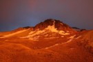
Dawn, Craigieburn Range.
Photograph.
Distance from location:
450m.
Broken River Ski Area in summer.
More ▶︎
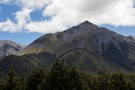
Mount Wall
Photograph.
Distance from location:
1.1km.
1874m peak on the Craigieburn Range. The Broken River Ski Club occupies the valley to the right.
More ▶︎
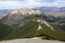
Camp Saddle / Lyndon Saddle spur
Photograph.
Distance from location:
1.8km.
Scree slope leading down to Lyndon Saddle and Helicopter Hill. Over the highway is the yellow Broken Hill, with the Torlesse Range beyond.
More ▶︎
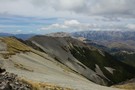
Camp Saddle / Lyndon Saddle spur
Photograph.
Distance from location:
1.8km.
Once up on Camp Saddle, it's a straightforward ridge cruise following the arc to the left.
More ▶︎
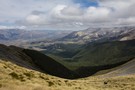
Camp Saddle
Photograph.
Distance from location:
1.8km.
The view south, down Camp Stream, Craigieburn Range.
More ▶︎
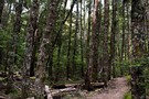
Dry beech forest
Photograph.
Distance from location:
1.9km.
Mistletoe Track, Craigieburn Forest.
More ▶︎