Nearby
Huitatariki Headwaters
Raukumara East-West Traverse
Track
•
5 – 12 days. Hard. One way.
•
Distance: 194m away
An east-west traverse of either the Raukumara range, or the entire East Cape. A minimum of 5-8 days in it's ...
More ▶︎
A Raukumara Crossing
Article
•
Distance: 194m away
The first leg of a trip from East Cape to West Cape via the main divide.
More ▶︎
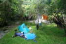
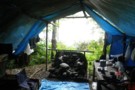
Huitatariki campsite
Photograph
•
Distance: 1.0km away
"We're stopping at the first spot of flat ground we find" - exhausted we drop down from Te Ranganuiatoi into ...
More ▶︎
Te Ranganuiatoi
Photograph
•
Distance: 1.8km away
The ridgeline 500m west of Te Ranganuiatoi at the saddle of the Okapua and Raukokore. We sidled south round the ...
More ▶︎
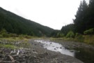
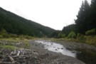
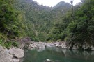
Huitatariki River
Photograph
•
Distance: 3.1km away
The Huitatariki open up as soon as it leaves the park, with broad grassy flats and pines of the valleysides. ...
More ▶︎
Huitatariki River
Photograph
•
Distance: 3.1km away
The Huitatariki open up as soon as it leaves the park, with broad grassy flats and pines of the valleysides. ...
More ▶︎
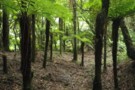
Ohapua Stream
Photograph
•
Distance: 3.4km away
Slow going up the Ohapua Stream - an obvious route from the Raukokore to the Huitatariki
More ▶︎
Tapuaeroa River
Photograph
•
Distance: 5.9km away
The Tapuaeroa River is the main access to the Oronui and Oronui Hut, and forms the most common eastern end-point ...
More ▶︎
Raukumara East-West Crossing
GPX file
•
Distance: 5.9km away
East-West crossing of the Raukumara Ranges. Starting either at East Cape, Te Kumi Station or Mt Hikurangi roadend, and ending ...
More ▶︎
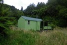
Oronui Hut
Photograph
•
Distance: 5.9km away
A welcome 6-bunk hut in the Eastern Raukumara ranges. The hut is in the Oronui river valley, where the valley ...
More ▶︎
Oronui Hut
Hut
•
Standard Hut (DOC). Capacity: 6.
•
Distance: 6.0km away
Oronui Hut. A standard 6-bunk hut in the eastern Raukumara Forest Park. 6 bunks, woodburner, tank water.
The hut is up ...
More ▶︎
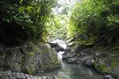
Oronui Gorge
Photograph
•
Distance: 6.4km away
The Oronui Gorge is a 6km stretch of winding, deep river valley below Oronui Hut. On the map it looks ...
More ▶︎
Te Kumi Flat tent camp
Hut
•
Shelter (NA). Capacity: 8.
•
Distance: 6.6km away
A tent camp on Te Kumi Flat in the Raukokore River int he Raukumara Range.
This is a privately built camp, ...
More ▶︎
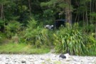
Te Kumi Flat tent camp
Photograph
•
Distance: 6.7km away
Looking up at the Te Kumi Flat tent camp from the Raukokore riverbed. A tidy, well designed tent camp on ...
More ▶︎
Te Kumi Flat tent camp
Photograph
•
Distance: 6.7km away
A well built, well designed tent camp in the Raukokore on Te Kumi Flat. Sited near north end on the ...
More ▶︎
Mangamauka Stream
Photograph
•
Distance: 7.0km away
The Mangamauka branches off the Oronui at Oronui hut, and forms the next leg of the Raukumara crossing track west ...
More ▶︎
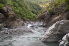
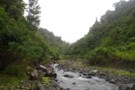
Raukokore River
Photograph
•
Distance: 8.3km away
Pools in the Raukokore a couple of km below Te Kumi Flat.
Access from Te Kumi STation, via the Waikura River.
More ▶︎
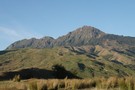
Mt Hikurangi
GPX file
•
Distance: 8.6km away
Could be done as a day trip but probably better to spend the night in the hut. It is quite ...
More ▶︎
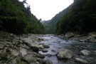
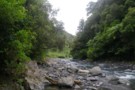
Raukokore River - rapids below Te Kumi
Photograph
•
Distance: 8.8km away
The Raukokore is generally easy going for a tramper from the confluence with the Waikura to Te Kumi Flats. However, ...
More ▶︎
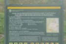
Sign at the carpark at the start of the Mt Hikurangi Trip
Photograph
•
Distance: 8.8km away
This sign gives some information that you need to know. The time to the hut is more like 3-4 hours ...
More ▶︎
Mt Hikurangi
Track
•
1 – 2 days. Medium. Return via same track.
•
Distance: 8.8km away
A classic trip up this sacred mountain, reputed to be the first place to see the sun on each new ...
More ▶︎