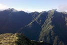
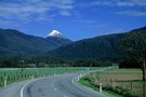
Alpine tops
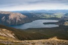
St Arnaud Range Track
Track.
1 day. Medium. Return by the same track.
Updated
6 October 20146 October 2014.
This walk climbs steadily through beech forest to a height of over 1650 metres.
Above the bushline (at 1400 m), there are spectacular views from Parachute Rocks, which gained their name from a parachute‐shaped gravel scree located just to the ...
More ▶︎
Mt Oxford
Track.
0 – 1 day. Medium. Return by the same track.
Created
21 September 201421 September 2014.
Day trip with several variations to make it a loop if desired.
More ▶︎
Pell Stream
Track.
2 – 3 days. Medium. Loop track with a road section.
Updated
18 November 202318 November.
This highly recommended valley not far from the highway west of the Lewis pass, is accessible to most people with a bit of tramping experience and a lot of common sense. The full traverse of the creek described here offers ...
More ▶︎
Pudding Hill Stream Route
Track.
1 day. Medium. One way.
Updated
27 August 201427 August 2014.
Unmarked route along Pudding Hill Stream in Mount Hutt Forest. Combine this route with the Scotts Saddle Track for an interesting circuit.
More ▶︎
Waingawa Track
Track.
Medium. One way.
Updated
29 September 201429 September 2014.
This is a non maintained route leading from Arete Forks up to the point of Waingawa 1420 Metres.The route meets the ridge top 300 metres west of Waingawa.
This was an access track developed by the NZ Forest Service for the ...
More ▶︎
Patutu
Track.
1 day. Easy/medium. Return by the same track.
Updated
3 July 20163 July 2016.
Day trip to the summit of Patutu (1162m). The track starts basically at sea level.
More ▶︎
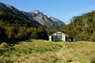
Paringa Valley to Tunnel Creek
Track.
Easy/medium. Return by the same track.
Updated
4 April 20154 April 2015.
Its a Southern West Coast gem: the valley floor is surprisingly gentle, the track currently well marked and for the most part easy to follow. Dense west coast bush and open river flats lead to a classic backcountry hut with ...
More ▶︎
Mount Guy
Track.
1 day. Medium. Loop track.
Created
18 June 201418 June 2014.
This loop takes in a little mountain and expansive views over Lake Clearwater and the Hakatere Basin.
More ▶︎
The Kaweka Main Range - a NS traverse
Track.
5 – 10 days. Easy/medium. One way.
Updated
25 April 201625 April 2016.
A Kaimanawa-Kaweka traverse from Rangataiki to the Gentle Annie (Napier-Taihape) summit.
5-10 days of good track-tramping through the beech & manuka forest, vividly coloured sub-alpine ridges and barren rocky tops of the Kaimanawa and Kaweka Range.
This route formed one leg of ...
More ▶︎
Mt Lyndon
Track.
0 – 1 day. Easy/medium. Return by the same track.
Created
7 June 20147 June 2014.
Day trip of moderate ascent of 650 m hill overlooking Lake Lyndon near Porters Pass. Route goes via low open scrub and easily climbed sections of scrubby groundcover and open patches of rock-studded soft earth.
More ▶︎
East Cape to West Cape - the length of NZ's main divide
Track.
125 – 300 days. Hard. One way.
Updated
3 February 20213 February 2021.
A guide to my route from East Cape to West Cape, the length of NZ's main divide.
More ▶︎
Mt Turiwhate track
Track.
1 day. Medium. Return by the same track.
Updated
31 July 201531 July 2015.
A route from SH73 at Grahams Creek, Turiwhate up to the tussock tops from where you can continue to the Turiwhate trig beacon or other high points on the Turiwhate Range.
Great views are to be had from the crest of ...
More ▶︎
Klondyke Spur
Track.
1 day. Medium. Return by the same track.
Created
18 March 201418 March 2014.
A route from Rahu Saddle onto the unnamed peaks of the Victoria Range.
More ▶︎
Cloustons Mine Track
Track.
Easy/medium. One way.
Updated
16 March 201416 March 2014.
Leading from the Salisbury Track on Flora Stream up past Cloustons Mine to Gordons Pyramid (1489m).
More ▶︎
Steepface Hill
Track.
1 day. Medium. Return by the same track.
Updated
17 February 201417 February 2014.
A vigorous climb to a summit on the Mount Hutt Range. Spectacular views across the Rakaia River, Lake Coleridge, and beyond.
More ▶︎
Walking the length of the Richmond Ranges
Track.
7 – 14 days. Medium/hard. One way.
Updated
8 January 20148 January 2014.
A 7-14 day walk along the spine of the Richmond Ranges. Alpine tops, crumbling ridgelines, untracked bush & scrub, boulders of abrasive ultramafic rock - not for the fainthearted, but the challenge is well rewarded.
More ▶︎
St Arnaud to Lewis Pass
Track.
5 – 9 days. Medium/hard. One way.
Created
8 January 20148 January 2014.
A 5-9 day north-south route from St Arnaud to the Lewis Pass, via Travers Pass, Waiau Pass, Thompson Pass and Three Tarn Pass. takes in good sections of the Travers, Sabine, Matakitaki and Maruia valleys.
More ▶︎
Walking the length of the Ruahines
Track.
10 – 25 days. Medium/hard. One way.
Updated
8 January 20148 January 2014.
A 10+ day trip down to backbone of the Ruahine Range from Wharite (Palmerston Sth) to the Napier Taihape (Gentle Annie) Rd.
The details of the route are in the associated article (see 'More Information').
More ▶︎
Sealy Tarns
Track.
Easy/medium. Return by the same track.
Created
5 December 20135 December 2013.
Steep track with lots of steps, but easy and well-maintained. The tarns are roughly half-way to Mueller Hut. From the tarns to Mueller Hut the track is a hard and avalanche-prone walking route.
More ▶︎
Old Ghost Road
Track.
3 – 5 days. Medium. One way.
Updated
28 October 202228 October 2022.
A four or five day tramp from the Lyell Campsite(off SH6 in the Buller Gorge) to the Mokihinui road end (off SH67 near Seddonville). This trip uses the Mokihinui-Lyell-Backcountry-Trust (MLBT) cycle trail.Tramping times given. DOC has information on their website ...
More ▶︎
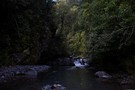
Mt Owen via Sunrise Peak, return Fyfe Rive
Track.
3 days. Hard. Loop track.
Created
14 November 201314 November 2013.
Southern approach to Mt Owen, steep terrain, epic rock formations on the tops - making for stunning views but slow horizontal travel.
Fyfe River valley - pools, great bird life and plenty of whio to be seen
More ▶︎

Lake Peel
Track.
1 day. Easy/medium. Return by the same track.
Created
6 August 20136 August 2013.
Pleasant walk to an alpine lake in the Cobb Valley.
More ▶︎
Mount Somers Summit Track
Track.
1 day. Easy/medium. Return by the same track.
Created
27 May 201327 May 2013.
The quicker, steeper route to the summit, from Sharplin Falls.
More ▶︎
Tin Range
Track.
2 days. Medium/hard. One way.
Updated
11 May 201311 May 2013.
This route traverses a remote range on Stewart Island, formerly home to tin miners and the country's last wild kakapo population.
More ▶︎
Robinson Saddle
Track.
3 days. Easy/medium. One way.
Updated
1 May 20131 May 2013.
Forest and tops walk in Victoria Forest Park, visiting Lake Christabel.
More ▶︎
Falls Creek
Track.
1 – 2 days. Medium. Return by the same track.
Created
28 April 201328 April 2013.
Day or overnight trip to a choice of two rock bivvies off the Milford Road.
More ▶︎
U Pass
Track.
1 – 2 days. Medium. Loop track.
Created
28 April 201328 April 2013.
A short loop track in the Earl Mountains.
More ▶︎
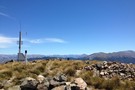
Mt Haast
Track.
Easy/medium. Return by the same track.
Updated
25 April 201325 April 2013.
A steep but satisfying climb. Great views and an alpine environment reasonably accessable from the road
More ▶︎
Lake Wilson and the Valley of the Trolls
Track.
2 – 3 days. Medium. Return by the same track.
Updated
28 February 201828 February 2018.
An overnight or multiday scenic diversion from the Routeburn Great Walk. The Valley of the Trolls is easily accessed from Harris Saddle and provides overnight camping for those wanting to get away from the crowds, while Lake Wilson provides stunning ...
More ▶︎
Sparrowhawk Biv Barlow hut loop
Track.
2 – 3 days. Medium. Loop track.
Updated
17 March 201317 March 2013.
A good solid Ruahine climb to a 3 person biv well situated with a great views, Tops travel then a quick 800 metre descent to a trout filled river and an 8 bunk hut
More ▶︎