Pinchgut Hut via Mt Thomas, Bobs Camp Biv
Mt Thomas Forest
- 2 – 3 days loop track
- Medium
Two day tramp on the ridges around Pinchgut Valley
|
Walking time
|
2 – 3 days
11 hr – 17 hr
|
|---|---|
|
Distance
|
29.0km |
|
Type
|
Loop track
|
|
Grade
|
Medium
Steep grades up to 30 degrees; no water (ridge track), exposed to weather; Grades explained
|
|
Bookings
|
No bookings — open access
No — open access
|
|
Starts
|
Wooded Gully Carpark (Mt Thomas Forest, Canterbury) |
|---|---|
|
Ends
|
Wooded Gully Carpark |
|
Maps
|
NZTopo50-BW22
|
|
Altitude
|
345m
–
1,045m
Altitude change 700m
|
I estimated that the round trip from Wooded Gully car park in the Mt Thomas Forest reserve to Pinchgut Hut, returning via Bob’s Camp Biv would be an easy weekender, perfect for getting a little training for our upcoming Humpridge Track booking in late spring. Measuring the distance on my Freshmap software gave me 10, maybe 12 kilometres at the outside for the trip out, and 13-15 for the return. This is the Canterbury foothills, Christchurch’s well-trodden playground. How hard could it be?
Ominously, the track was playing hard-to-get on Doc’s web site. Pinchgut Hut is usually reached through a river route in 2-3 hours, but we wanted to tramp all the way around the tops framing Pinchgut Valley, which can be reached via a ridge stretching North West from Mt Thomas. It is well signposted but, as we found out, with some of the most optimistic times I have ever encountered in the New Zealand outdoors.
Our party of four set out on a glorious Canterbury late-winter day, with not a cloud in the sky and barely a breeze stirring the air. Getting up on the ridge west of Mt Thomas via the Wooded Gully Track was plain sailing, and we decided to take a detour as two in our group hadn’t actually been on Mt Thomas itself, which added an hour or so to the trip. Back on the main track we soon reached the turnoff to the Hut and the Biv, and the change in terrain was noticeable immediately on leaving the main track. A path was no longer obvious, the terrain was overgrown with tussock and low shrubs and we also had to contend with patches of snow. We reached the junction of the loop around Pinchgut valley after a scramble down a rather steep and rocky hillside and were greeted by a sign advising a 1.5 hour further traveling time to the Hut.
We reached it after a 2.5 hour slog that involved negotiating fallen trees, more steep (but grassy) hillsides, and more tiring tussock-bashing. Instead of the expected 4-5 hours we had marched seven that day, including the detour to the top of Mt Thomas.
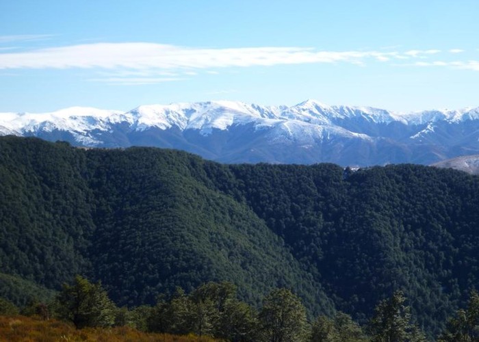
After a night at the cosy seven-bunk hut under a sky full of stars, which was totally unspoilt by any artificial light, we were greeted by a generous layer of frost on the grass around the hut the next morning. We wrapped up against the cold, but in less than half an hour we were back to T-s and shorts as we climbed straight up a ridge which caught full sun on this absolutely still day. The three hours it took us to reach an unnamed peak of 1,083 m, the highest point of our trip, were exhausting work through patches of snow on steep slopes, bush bashes over, under and through fallen branches and trees, and more stomping through tussock and waist-high shrubbery, at times peppered with thorny plants such as gorse, matagouri and Spaniards. Along the way, and especially at the top, we got treated to an awesome Southern Alps panorama which still featured plenty of snow, though.
The route undulated its way to the turnoff to Bob’s Camp Biv, and from here a clear track was finally visible again. Between the hut and this point we had seen no sign that this route had been used recently, or even not so recently. At times we had only been able to guess at a trodden path, only to lose it again in shrubbery or snow, and we were rather glad that Doc had provided plenty of markers, even though getting from one to the next was rather less than straightforward at times.
We were now able to travel a bit faster on an established track mostly through forest, but we all felt exhausted, tired out from terrain that felt as if it had to be fought rather than tramped. The steep ridge connecting Mt Thomas with the route around Pinchgut Valley also still needed to be conquered, and we all dreaded it as we remembered the descent on the previous day. We also found that we hadn’t packed enough water – as the entire return trip was along ridges there was not a drop of it to be collected en route. Much of the track was exposed to the full sun, and there was no breeze that day to cool us down.
The car was a welcome sight after a whopping 8 ½ hours of tramping. The stats weren’t even that impressive: about 16 kilometres with about 1500 metres gained in total each day. We’ve certainly done longer and felt less worn on other tracks.
Pat joked that we’ve done it the wrong way around: the Humpridge should have been the training for this one. Maybe. I reckon the Humpridge can’t possibly be more than 4-5 hours a day…