Mt Owen via Sunrise Peak, return Fyfe Rive
- 3 days loop track
- Hard
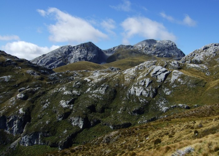
Southern approach to Mt Owen, steep terrain, epic rock formations on the tops - making for stunning views but slow horizontal travel. Fyfe River valley - pools, great bird life and plenty of whio to be seen
|
Walking time
|
3 days
7 hr – 10 hr
|
|---|---|
|
Type
|
Loop track
|
|
Grade
|
Hard
Steep terrain leading up to Sunrise Peak
Rock formations and sink holes on tops creating difficult navigation - not some where to be in bad weather!
No water supply above Owen River - BYO
Many river crossings in Fyfe - has low flows if has not rained Grades explained
|
|
Bookings
|
No bookings — open access
No — open access
|
|
Starts
|
East Owen Road - there is a sign where to park |
|---|---|
|
Ends
|
Frying Pan Creek - can walk the final 1km back to car |
|
Maps
|
NZTopo50-BR23
|
|
Altitude
|
400m
–
1,875m
Altitude change 1,475m
|
So after a little bit of research, I have failed to find much in the way of useful information in regards to this trip. Thus I am hoping it may provide some use to other people.
Contact details for the farm for permission to cross / park / camp, and no access after dark without ringing first – 03 523 9280 (I can’t remember the name sorry!)
We (Rosie and myself) began our trip up the Owen River from the East Owen Road. Here it travels across farmland for about 2km before entering into the bush. The valley is stunning, plenty of pools and bird life to keep you occupied! After a few river crossings the track turns steeply uphill. Famous last words; “Oh it’s not that bad!”
Note at the last river crossing of the Owen it is advisable to carry plenty of water with you. This is because not only will you get rather thirsty on your slog up the hill, but also once you are on top of it, there is no water as far as we could see on the south side of Mt Owen. Thus if you fail to summit and get down the other side to where the water is, as you get lost in the maze of marble, you will need to camp and rely solely on any water you are carrying or snow you can find to melt.
But I digress… while the track starts as pleasant zigzags; it soon turns straight up the ridge. This ridge has a general trend of getting steeper and steeper, with some pleasant almost flat sections every now and again.
Once at the bush line, the ridge seems to get even steeper still and disappears amongst vertical rock faces! The nicely marked track seems to disappear into oblivion right about the time one would wish for it most. This is not a place to muck around or lose your cool, as the terrain is very steep, Spaniard filled and generally highly unpleasant.
We found there was some confusion over what the actual time was to where (as it was it 7hours to the top of Sunrise Peak or 7hours to the top of Mt Owen?) – and unfortunately DoC was not able to enlighten us much. But it took us roughly 6 hours including a brief lunch stop to get to the top of Sunrise Peak.
Once on the top, sighs of relief all round, one is greeted with the most awe-inspiring sight! The landscape in front of you is filled with huge rocky boulders, interspersed with giant man eating holes, archways and bluffs.
From the top of Sunrise Peak, it is meant to be only a few hours of walking to the top of Mt Owen. There are a few cairns dotted around the place, which we followed for a while. However, after 2.5 hours of walking / back tracking / hole avoiding / scrambling we felt we had not made much of a dent in the 2km that it was to the top of Mt Owen. We had reached a high point, from which the cairns seemed to disappear into oblivion, and despite large amounts of searching we could not relocate the route.
So we decided we must be knackered and thus lost our route finding abilities. We managed to eventually find a small piece of flat enough tussock to camp on with a small snow mound nearby that we could add to our 3L of water that we had carried up the hill for cooking etc.
Morning came and we were much back on form. We found the route and followed it for a while. It seemed to be leading us in a western traverse of the mountain, and so we assumed that once we reached the west facing ridge, we would be led to ascend at that point (as prior to that large rock cracks had barred our way). However, on arrival at said ridge, there was a lovely rock shelter created by someone, but once again there appeared to be no onwards route. We were stopped at this one point for over 45min, and despite much searching we could find no route towards the summit, or indeed down into Poverty Basin.
Eventually we found a route down into Poverty Basin, and the lovely open tussock that it was. Crossing this was an absolute breeze, and soon we reached the ridge between Replica Hill and Mt Owen. At this point we could see part of the track from Granity Hill Hut to the summit, but despite perfect weather, we were well and truly exhausted, thirsty and terrified that the ridge heading from Replica Hill to point 1500 (to drop into the Fyfe) would be more of the same.
Crossing from Sunrise Peak to this ridge took around 5 hours, due to difficult route finding. We are still unsure as to where the correct route from Sunrise Peak to the summit of Mt Owen is, as the hut book in Branch Creek hut led us to believe we should have perhaps stayed on the eastern ridge, though we missed seeing a passable route along this way.
Fortunately, the route along the northern face of Replica Hill to point 1500 was extremely straightforward – simply open tussock and not a single boulder blocked our way. The aim was to stay high enough out of the marble maze, but low enough to avoid the steep upper slopes and excess climbing.
The track where it enters the bush to drop into the Fyfe is now very well marked with 2 large orange triangles. It drops rather steeply into the valley below, with lovely orange markers guiding the way literally every few metres. It takes roughly just under an hour from the bush line to Branch Creek Hut.
The track out from here is currently in very good condition. There are a few points where the track climbs high above a gorge or two and the track can be rather narrow and feel a little exposed in places, but by comparison to the previous days, it feels like a walk in the park. It is a long way down and did take us the full 8 hours with breaks included. There was a surprise DoC biv part way down the valley (at the junction of the track described below). My Topo50 map had 2 tracks leading over from the Fyfe to Frying Pan Creek. The track that goes via Sandstone Creek (if you have this marked) is in fact only used as a DoC trap line, where as the other one is very well marked and worn. This valley is stunning, with plenty of lovely pools and swimming holes. We saw 5 whio amongst other birds.
The last section of track follows farmland and then a farm track leads you back to your car on the East Owen Road.
Be warned, the sandflies on the upper East Owen Road were second to none! They out do Rotoroa hands down for ferociousness – determined to bite despite a stiff breeze and repeated swatting.
Good luck! Anyone with more information regarding the best general trend of a route from Sunrise Peak to Mt Owen would be welcomed!